
Val-de-Travers
Val-de-Travers is a municipality in the canton of Neuchâtel in Switzerland. It was created on 1 January 2009, when the former municipalities of Boveresse, Buttes, Couvet, Fleurier, Les Bayards, Môtiers, Noiraigue, Saint-Sulpice and Travers merged to form Val-de-Travers.[2]
The region is known for its production of absinthe.
History
Val-de-Travers is first mentioned in 1150 as Vallis traversis.[3]
Geography


Val-de-Travers has an area of 124.9 square kilometers (48.2 mi2). Of this area, in 2009 52.92 km2 (20.43 mi2) or 42.4% was used for agricultural purposes, while 63.24 km2 (24.42 mi2) or 50.6% was forested. Of the rest of the land, 7.54 km2 (2.91 mi2) or 6.0% is settled (buildings or roads), 0.59 km2 (0.23 mi2) or 0.5% either rivers or lakes and 0.39 km2 (0.15 mi2) or 0.3% is unproductive land.[4]
Of the built-up area, housing and buildings made up 2.5% and transportation infrastructure made up 2.5%. Out of the forested land, 46.8% of the total land area is heavily forested and 3.8% is covered with orchards or small clusters of trees. Of the agricultural land, 5.0% is used for growing crops and 23.9% is pastures and 13.4% is used for alpine pastures. All the water in the municipality is flowing water.[4]
The municipality is located in a valley in the Neuchâtel Jura. The valley provides a connection between the Swiss Plateau and Franche-Comté.
The river L'Areuse (previous called La Reuse, the name morphed into Areuse), flows lengthways of the valley, most of this river is a shallow river, and about 10 meters wide, it narrows into a gorge near Noiraigue. Historically, this river provided much of the water and fish for the valley.
The municipality was located in the Val-de-Travers District, until the district level was eliminated on 1 January 2018.[5]
Môtiers is the main village.
Demographics

Val-de-Travers had a population (as of December 2020) of 10,579.[6]As of 2008, 18.0% of the population are resident foreign nationals.[7] In the 10 years (2000–2010) the population decreased by 2.5%. Migration accounted for -1.8% whilst births and deaths accounted for -1.6%.[8]
Most of the population (as of 2000) speaks French (88.9%) as their first language, Italian is the second most common (3.0%) and German is the third (2.7%).[8]
As of 2008 the population was 48.6% male and 51.4% female. The population was made up of 4,161 Swiss men (38.4% of the population) and 1,103 (10.2%) non-Swiss men. There were 4,677 Swiss women (43.2%) and 891 (8.2%) non-Swiss women.[9]
As of 2000, children and teenagers (0–19 years old) make up 25% of the population, while adults (20–64 years old) make up 55.9% and seniors (over 64 years old) make up 19.1%.[8]
As of 2009, the construction rate of new housing units was 0.6 new units per 1000 residents.[8] The vacancy rate for the municipality, in 2010, was 1.39%.[8]
Heritage sites of national significance
The Farm House no. 1201 or Monlési, the Maison des Chats or Petitpierre, the Séchoir à absinthe, Ivernois Castle and the Maison Boy de la Tour, the Hôtel des Six-Communes, the medieval church of St-Pierre, the Temple in Môtiers and Areuse Bridge are listed as Swiss heritage site of national significance. The villages of Buttes, Les Verrières, Môtiers, Couvet, Fleurier and Travers are all part of the Inventory of Swiss Heritage Sites.[10]
 Farm House no. 1201 or Monlési
 Maison des chats
 Séchoir à absinthe in Boveresse
 Motiers-Hotel-Six-Communes, previously a midway station
 Medieval church of St-Pierre
 Temple of Môtiers
 Areuse Bridge
Economy
As of 2010بلغت نسبة البطالة في فال دو ترافير 6.6%. اعتبارًا من عام 2008بلغ عدد العاملين في القطاع الاقتصادي الأولي 322 شخصًا ، موزعين على نحو 139 شركة. أما في القطاع الثانوي ، فبلغ عدد العاملين 1980 شخصًا، موزعين على 162 شركة. وفي القطاع الثالث، بلغ عدد العاملين 2188 شخصًا ، موزعين على 374 شركة. [ 8 ] وكان من بين سكان البلدية من يعملون في وظائف مختلفة. ومن بين القوى العاملة، استخدم 13.1% منهم وسائل النقل العام للوصول إلى العمل، بينما استخدم 57.3% سياراتهم الخاصة. [ 8 ]
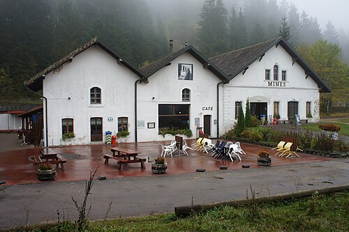
تم استغلال الأسفلت حتى عام 1986 في منجم لا بريستا للأسفلت . وهو الآن متحف.
تعليم
في كانتون نوشاتيل، تُوفر معظم البلديات سنتين من رياض الأطفال غير الإلزامية ، تليها خمس سنوات من التعليم الابتدائي الإلزامي. أما السنوات الأربع التالية من التعليم الثانوي الإلزامي فتُقدم في ثلاث عشرة مدرسة ثانوية كبيرة، يسافر إليها العديد من الطلاب من خارج بلدياتهم الأصلية. [ 11 ] خلال العام الدراسي 2010-2011، بلغ عدد فصول رياض الأطفال في فال دو ترافير 10.5 فصلًا، بإجمالي 198 طالبًا. وفي العام نفسه، بلغ عدد فصول المرحلة الابتدائية 29 فصلًا، بإجمالي 528 طالبًا. [ 12 ]
مواصلات
تضم البلدية سبع محطات قطار. تقع محطتان، ترافير ونواريغ ، على خط نوشاتيل-بونتارلييه الذي يخدم نوشاتيل وفرنسا . أما المحطات الخمس الأخرى فتقع على خط ترافير-بوت ، الذي يخدم ترافير أيضاً.
شخصيات بارزة


- إيمر دي فاتيل (1714 في كوفيه - 1767) محامٍ دولي
- فرديناند بيرثود (1727 في بلانسيمونت سور كوفيه – 1807) عالم وصانع ساعات
- جوناس دي جيليو (1740 في ليه بايار - 1827) قس سويسري ومربي نحل
- سالومي دي جيليو (1742 في ليه بايار - 1820) مربية ومعلمة سويسرية لعدد من أفراد البلاطات الأميرية في أوروبا
- ليو ليسكيرو (1806 في فلورييه - 1889) عالم نباتات زينة سويسري ورائد في علم النباتات القديمة الأمريكي
- إدوارد بياجيه (1817 في ليه بايار - 1910) عالم حشرات سويسري متخصص في القمل
- شارل إدوارد غيوم (1861 في فلورييه - 1938) فيزيائي سويسري حصل على جائزة نوبل في الفيزياء عام 1920
- إدوارد بوفيه (1797 في فلورييه - 1849) صانع ساعات سويسري ومؤسس شركة ساعات بوفيه فلورييه
- دينيس دي روجيمون (1906 في كوفيه - 1985) كاتب سويسري ومنظر ثقافي
- دانيال بوفيه (1907 في فلورييه - 1992) عالم صيدلة إيطالي من أصل سويسري، حائز على جائزة نوبل في الطب أو علم وظائف الأعضاء عام 1957 لاكتشافه أدوية تحجب عمل ناقلات عصبية محددة.
- فريتز تشانين (1920 - 2011 في فال دو ترافيرس)، عازف أكورديون سويسري، ومتزلج قفز سابق شارك في دورة الألعاب الأولمبية الشتوية لعام 1948، وقائد أوركسترا حتى عام 1999، عندما تقاعد في فلورييه.
مراجع
- ^ “Arealstatistik Standard – Gemeinden nach 4 Hauptbereichen” (في المانيا). المكتب الإحصائي الاتحادي . تم الاسترجاع في 13 يناير 2019 .
- ^ Amtliches Gemeindeverzeichnis der Schweiz نشره المكتب الإحصائي الفيدرالي السويسري (باللغة الألمانية) تم الوصول إليه في 14 يناير 2010
- ↑ "Val- de -Travers" باللغات الألمانية والفرنسية والإيطالية في القاموس التاريخي لسويسرا على الإنترنت .
- 1 2 بيانات المكتب الإحصائي الفيدرالي السويسري - إحصاءات استخدام الأراضي لعام 2009 (باللغة الألمانية) تم الاطلاع عليها في 25 مارس 2010
- ^ Amtliches Gemeindeverzeichnis der Schweiz (بالألمانية) تم الوصول إليه في 15 فبراير 2018
- ^ "Ständige und nichtständige Wohnbevölkerung nachtitutionellen Gliederungen, Geburtsort und Staatsangehörigkeit" . bfs.admin.ch (باللغة الألمانية). المكتب الإحصائي الفيدرالي السويسري - STAT-TAB. 31 ديسمبر 2020 . تم الاسترجاع في 21 سبتمبر 2021 .
- ↑ المكتب الإحصائي الفيدرالي السويسري – قاعدة بيانات Superweb – إحصاءات البلديات 1981-2008 (باللغة الألمانية) تم الاطلاع عليها في 19 يونيو 2010
- 1 2 3 4 5 6 7 المكتب الفيدرالي السويسري للإحصاء ، تم الاطلاع عليه في 3 نوفمبر 2011
- ^ كانتون نوشاتيل إحصائيات الرابط المهمل أرشفة 5 ديسمبر 2012 في archive.today ، République et canton de Neuchâtel – Recensement annuel de la السكان (بالألمانية) تم الوصول إليه في 13 أكتوبر 2011
- ↑ "قائمة الكانتون للأشياء من الفئة أ" . جرد مكتب KGS (بالألمانية). المكتب الاتحادي للحماية المدنية. 2009. مؤرشف من الأصل في 28 يونيو 2010. تم الاطلاع عليه في 25 أبريل 2011 .
- ^ إي دي كيه/سي دي آي بي/إيديس (2010). Kantonale Schulstrukturen in der Schweiz und im Fürstentum Liechtenstein / Structures Scolaires Cantonales en Suisse et Dans la Principauté du Liechtenstein (PDF) (أبلغ عن) . تم الاسترجاع 24 يونيو 2010 .
- ↑ قسم الإحصاء في كانتون نوشاتيل، مؤرشف في 14 أبريل 2012 على موقع Wayback Machine ، مذكرات السنة الدراسية 2010/2011 (بالفرنسية) ، تم الاطلاع عليها في 17 أكتوبر 2011
روابط خارجية
- كلمة "Boveresse" باللغات الألمانية والفرنسية والإيطالية في القاموس التاريخي لسويسرا على الإنترنت .
- بلديات كانتون نوشاتيل
- ممتلكات ثقافية ذات أهمية وطنية في كانتون نوشاتيل