
Inner Banks
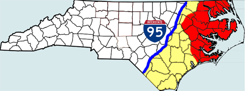
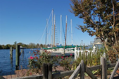
The Inner Banks are the inland coastal region of eastern North Carolina. Without historical precedent, the term "Inner Banks" is an early 21st-century construct that is part of an attempt to rebrand the mostly agrarian Coastal Plains east of I-95 as a more attractive region for visitors and retirees.
Background

The current Inner Banks region was historically grouped with the Sandhills as the Carolinas and Georgia's Piney Woods. Around the time of the Civil War, people from the area were known as "Goobers".[1][2] The regional name and demonym fell from use over time as the area was deforested.
The present term suggests relation to the historical area known as the Outer Banks, a string of barrier islands off the coast of North Carolina that have long been a popular tourist attraction. The demand for waterfront property in eastern North Carolina as a site for second homes for the relatively wealthy has resulted in a tremendous disparity of prices in such locales. Frequently otherwise equivalent lots on opposite sides of a road will have broadly divergent tax and appraisal values. For example, on Rock Creek Road in Jones County, riverfront lots on the Trent River had a tax value of $201,286 per acre; lots immediately across the road had a tax value of $33,634 per acre, according to the Jones County GIS maps.
The developers and tourism promoters have broadly defined the Inner Banks as an area on the East Coast of North Carolina that is 22,227 square miles (57,568 km2).[3] The so-called Inner Banks comprises over 3,000 miles of inland coastline and is home to over 2.5 million residents. Marketing people include the Crystal Coast and Albemarle regions of the state in the Inner Banks. Having a moderate climate, the area is becoming a popular destination for retirees and small business entrepreneurs.[4] "Inner Banks" is sometimes abbreviated with the acronym IBX, another attempt at trendiness.[3]
The general definition states that the Inner Banks is a region between Interstate 95 to the west, the Outer Banks to the east, and extend from the Virginia border to the South Carolina border. Consisting of 41 counties, the region is three times the size of the state of New Jersey. Many areas farther from the sounds and tidal rivers have not embraced the Inner Banks brand and are seldom included in the definition. Traditionally dependent on agriculture and the textile industry, eastern North Carolina has worked to redefine the region's strengths to transition into the new global economy.
Six small towns in the Inner Banks have joined in what they call the Creative Communities Initiative.[5] They are working to foster an environment attractive to knowledge workers, artists, and other people working in the creative economy. These six towns are: Ayden, Edenton, Hertford, Murfreesboro, Plymouth, and Tarboro.
Albemarle Region
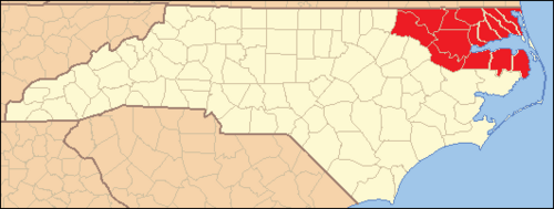
Northeastern North Carolina (or the Albemarle Region) consists of 14 counties in northeast North Carolina that surround Albemarle Sound and its tributaries, such as the Chowan and the Roanoke rivers. It has numerous attractions in terms of its undeveloped beaches, rivers, and small towns. Historic sites within the Albemarle Region are identified along the Historic Albemarle Tour.
History
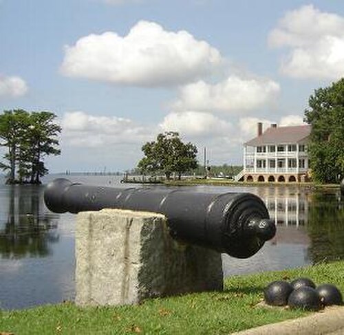
This waterway-rich region was inhabited for thousands of years by various cultures of indigenous peoples. By the historic period of European contact, the coastal area was occupied primarily by Algonquian-speaking tribes. The other two major language families of historic tribes in the state were Siouan languages and Iroquoian languages.
After European contact, the area which is now northeastern North Carolina and southeastern Virginia was one of the first in North America to be settled by English and related northern Europeans. Virginia Dare was born on nearby Roanoke Island in 1587, in what is today part of North Carolina. She is recorded as the first English child born in North America. The Roanoke colony did not survive.
منذ القرن السابع عشر وحتى ما قبل الحرب الأهلية، كان التبغ والقطن هما المحصولان النقديان الرئيسيان، وكلاهما يتطلبان عمالة كثيفة في الزراعة والتصنيع. استورد كبار المزارعين آلاف الأفارقة المستعبدين لعمالتهم حتى عام ١٨٠٨، حين حظر الكونغرس تجارة الرقيق عبر المحيط الأطلسي. وكان هؤلاء وذريتهم عنصرًا أساسيًا في بقاء ونجاح مستعمرة كارولاينا الشمالية، ثم الولاية لاحقًا. وكان التبغ يتطلب عمالة كثيفة بشكل خاص، كما أنه يستنزف التربة. لذا، تحول بعض أوائل مزارعي التبغ إلى الزراعة المختلطة بحلول نهاية القرن الثامن عشر لاستعادة خصوبة أراضيهم.
كانت معظم المنطقة مزدهرة نسبيًا للمزارعين البيض حتى اندلاع الحرب الأهلية الأمريكية . وأصبحت الأراضي الزراعية الخصبة وقطاعات الشحن هدفًا متكررًا لغزوات قوات الاتحاد . وقد أُحرقت عدة بلدات في المنطقة بالكامل على يد قوات الاتحاد خلال هذه الفترة، بما في ذلك بليموث ووينتون . وفي بليموث، استخدمت قوات الكونفدرالية لأول مرة سفينة حربية مدرعة ، وهي السفينة الحربية المدرعة "سي إس إس ألبيمارل " .
بعد الحرب، كان تغيير اقتصاد المنطقة بطيئاً. واستمرت المنطقة في الاعتماد على الزراعة كقاعدة اقتصادية رئيسية، والتي عانت من تراجع حتى نهاية القرن التاسع عشر.
الساحل الأوسط

تتألف منطقة الساحل الأوسط أو منطقة بامليكو من خمس مقاطعات في شرق ولاية كارولاينا الشمالية ، تطل على خليج بامليكو وروافده، مثل نهري نيوس وبونغو . وتشمل هذه المنطقة أيضاً الجزء الجنوبي من جزر أوتر بانكس ومعظم ساحل كريستال في مقاطعة كارترت .
منطقة كيب فير

تتألف منطقة جنوب شرق ولاية كارولاينا الشمالية (أو منطقة كيب فير ) من عشر مقاطعات تقع في جنوب شرق ولاية كارولاينا الشمالية ، وتحدها نهر كيب فير وروافده، مثل نهري بلاك وساوث . وتتكون المنطقة في المقام الأول من أراضٍ زراعية ريفية ومجتمعات ساحلية.
منطقة
المقاطعات

فيما يلي قائمة بالمقاطعات التي تُعتبر عادةً جزءًا من منطقة إنر بانكس (مدرجة أبجديًا):
عمومًا:
- مقاطعة بوفورت
- مقاطعة بيرتي
- مقاطعة كامدن
- مقاطعة كارترت
- مقاطعة تشوان
- مقاطعة كريفن
- مقاطعة كوريتوك الرئيسية
- مقاطعة دار الرئيسية
- شرق مقاطعة إيدجكومب
- مقاطعة غيتس
- مقاطعة هاليفاكس الشرقية
- مقاطعة هيرتفورد
- مقاطعة هايد الرئيسية
- شرق مقاطعة جونز
- مقاطعة مارتن
- مقاطعة نورثهامبتون
- مقاطعة أونسلو الشرقية
- مقاطعة بامليكو
- مقاطعة باسكوتاك
- مقاطعة بيركيمانز
- مقاطعة بيت
- مقاطعة تيريل
- مقاطعة واشنطن
- مقاطعة واين
أحياناً:
المدن والبلدات
فيما يلي قائمة ببعض المدن والمجتمعات في منطقة إنر بانكس (مرتبة أبجديًا):
- أهوسكي
- أيدن
- أراباهو
- أورورا
- حمام
- بايبورو
- بوفورت
- بيلهافن
- بيت إيل
- كامدن
- تشوكوينييتي
- كولومبيا
- كورابيك
- كريسويل
- كوريتوك
- إيدنتون
- مدينة إليزابيث
- يور
- يوريكا
- فارمفيل
- فريمونت
- البوابات
- غيتسفيل
- غرينفيل
- جولدسبورو
- غريفتون
- هامبستيد
- جزيرة هاركرز
- هافلوك
- هيرتفورد
- هوبسفيل
- جاكسونفيل
- جزيرة نوتس
- مدينة موريهيد
- مويوك
- مورفريسبورو
- نيو بيرن
- نيوبورت
- أوك سيتي
- شرقي
- بانتجو
- بليموث
- روبرسونفيل
- رودوكو
- روبر
- ستانتونسبيرغ
- صنبري
- حي سوان
- سوانسبورو
- تاربرو
- ترينتون
- فانسيبورو
- واشنطن
- ويليامستون
- وندسور
- فوز
- وينترفيل
- وينتون
الحدائق

محميات الحياة البرية
الكليات والجامعات
- جامعة تشوان
- جامعة كارولينا الشرقية
- جامعة ولاية مدينة إليزابيث
- جامعة ميد-أتلانتيك المسيحية
- كلية مقاطعة بوفورت المجتمعية
- كلية كارترت المجتمعية
- كلية كارولينا الساحلية المجتمعية
- كلية ألبيمارل
- كلية كريفن المجتمعية
- كلية إيدجكومب المجتمعية
- كلية هاليفاكس المجتمعية
- كلية مارتن المجتمعية
- كلية بامليكو المجتمعية
- كلية بيت المجتمعية
- كلية روانوك-تشوان المجتمعية
انظر أيضاً
مراجع
- ↑ "goober, n. "، قاموس أكسفورد الإنجليزي ، أكسفورد: مطبعة جامعة أكسفورد.
- ^ شيلي دي فير، ماكسيميليان (1871)، الأمركة ، ص. 57 .
- 1 2 "حرم كارولينا الداخلي" (ملف PDF) . صحيفة تامبا تريبيون. 15 أكتوبر 2006. مؤرشف من الأصل (ملف PDF) في 28 سبتمبر 2007. تم الاطلاع عليه في 5 فبراير 2007 .
- ↑ "سلسلة: الواجهة البحرية الجديدة" . صحيفة نيوز أند أوبزرفر. 31 يوليو 2006. مؤرشف من الأصل في 1 يوليو 2006.
- ↑أُرشف بتاريخ 27 سبتمبر 2007 في أرشيف الإنترنت (Wayback Machine) .
- شرق ولاية كارولاينا الشمالية
- مناطق ولاية كارولاينا الشمالية