
Pardubice Region
Pardubice Region (Czech: Pardubický kraj) is an administrative unit (Czech: kraj) of the Czech Republic, located mainly in the eastern part of its historical region of Bohemia, with a small part in northwestern Moravia. It is named after its capital Pardubice. As an administrative unit, Pardubice Region has existed three times in the course of history. It was established for the first time in 1850, and extended from Český Brod to the Bohemian-Moravian border. In its second existence, it was one of 19 regions as they were set between 1949 and 1960. After 1960, Pardubice became the capital of Pardubice district, which was part of the Eastern Bohemian Region (capital Hradec Králové). The Pardubice Region, as it is now, was reestablished in 2000.
Administrative divisions
The Pardubice Region is divided into 4 districts:
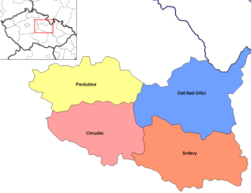 | ||||||||||
Districts of Pardubice Region
| ||||||||||
There are a total of 451 municipalities in the region (as of 2019).[3] Among these are 15 municipalities with extended powers and 26 municipalities with a delegated municipal office. Thirty-two of the municipalities are classified as towns. The regional central offices are in Pardubice.[4]
Population
The total population of the Pardubice Region is about 530,000. 17 municipalities have a higher population than 5,000. The largest municipality of the region is Pardubice with a population of more than 90,000. The table below shows the municipalities in Pardubice Region with the largest population (as of 1 January 2024).[5]
| Name | Population | Area (km2) | District |
|---|---|---|---|
 Pardubice Pardubice | 92,362 | 78 | Pardubice District |
 Chrudim Chrudim | 23,441 | 33 | Chrudim District |
 Svitavy Svitavy | 16,108 | 31 | Svitavy District |
 Česká Třebová Česká Třebová | 15,119 | 41 | Ústí nad Orlicí District |
 Ústí nad Orlicí Ústí nad Orlicí | 14,098 | 36 | Ústí nad Orlicí District |
 Vysoké Mýto Vysoké Mýto | 12,412 | 42 | Ústí nad Orlicí District |
 Litomyšl Litomyšl | 10,493 | 33 | Svitavy District |
 Lanškroun Lanškroun | 9,849 | 21 | Ústí nad Orlicí District |
 Moravská Třebová Moravská Třebová | 9,715 | 42 | Svitavy District |
Other significant towns in Pardubice Region are Hlinsko, Přelouč, Polička, Choceň, Holice, Letohrad and Žamberk.
Historical population | ||||||||||||||||||||||||||||||||||||||||||||||||||||||||
|
|
| ||||||||||||||||||||||||||||||||||||||||||||||||||||||
| Source: Censuses[6][7] | ||||||||||||||||||||||||||||||||||||||||||||||||||||||||
Geography
With a total size of 4,519 km2, Pardubice is the fifth smallest region in the Czech Republic. Králický Sněžník (1,424 m) is the highest point in the region. The lowest point (201 m) is situated on the water surface of the Elbe River near Kojice.
The southern and southeastern parts of the region are home to the hilly areas of Upper Svratka Highlands and Iron Mountains. The central and western parts of the region are formed by the Polabí lowlands. In the northeast, the region reaches the Orlické Mountains and Hrubý Jeseník range.
The European Watershed runs through the region, where it separates the basins of the North Sea and the Black Sea. The tripoint of the Danube (Black Sea), Elbe (North Sea) and Oder (Baltic Sea) watersheds is located at the peak of Klepáč in Králický Sněžník Mountains. The majority of the region belongs to the drainage basin of the Elbe, consisting of the rivers Chrudimka, Divoká Orlice, Doubrava, Loučná, Tichá Orlice and Třebovka. The rivers in the drainage basin of the Danube are the Morava, Moravská Sázava, Svitava and Třebůvka. The Seč Reservoir (220 ha) and the Pastviny Reservoir (92 ha) are among the larger water bodies in the region.
The most prevalent soil types in the region are podzol and cambisol. Forests cover 29.6% of the region and are predominantly coniferous. Deciduous forests occur around Pardubice.
Climate
Pardubice Region has a continental climate characterized by relatively hot summers and cold winters. The climate in Pardubice Region differs depending on location. The areas in the Polabí lowlands in the western part of the region are relatively warmer with annual mean temperatures reaching 8 °C. On the other hand, the coldest areas are situated in the hilly northeastern part of the region, where the annual mean temperatures are around 4 °C.
Precipitation is relatively lower in the central part of the region where the total annual values are around 700 – 800 mm. In the areas with higher elevation (such as Žďárské Vrchy or the foothills of Orlické Hory) there is higher precipitation with annual values of 800 – 1,000 mm.
| Climate data for Pardubice Region (1961–1990) | |||||||||||||
|---|---|---|---|---|---|---|---|---|---|---|---|---|---|
| Month | Jan | Feb | Mar | Apr | May | Jun | Jul | Aug | Sep | Oct | Nov | Dec | Year |
| Daily mean °C (°F) | −3.1(26.4) | −1.4(29.5) | 2.2(36.0) | 7.1(44.8) | 12.2(54.0) | 15.3(59.5) | 16.6(61.9) | 16.3(61.3) | 12.7(54.9) | 8.0(46.4) | 2.5(36.5) | −1.3(29.7) | 7.2(45.0) |
| Average precipitation mm (inches) | 47(1.9) | 40(1.6) | 42(1.7) | 46(1.8) | 77(3.0) | 87(3.4) | 82(3.2) | 84(3.3) | 56(2.2) | 45(1.8) | 52(2.0) | 54(2.1) | 711(28.0) |
| Source: Czech Hydrometeorological Institute[8] | |||||||||||||
Economy
The gross domestic product (GDP) per capita of the region was 81.1% of the national average in 2011. Services form the largest part of the region's economy, forming 52.4% of GDP in 2011. Other significant sectors are industry (36.9% of GDP) and construction (7.2% of GDP). The registered unemployment rate was 8.44% at the end of 2011. The highest unemployment rate was in Svitavy District.
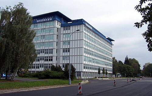
- Industry
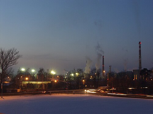
Industry and commercial public services are the basis of Pardubice's economy. General engineering, textiles, clothing, and leather processing are the strongest industrial branches. The chemical industry in Pardubice Region is larger than anywhere else in the Czech Republic.
- Transport
Road networks make up 3,597 km that transverse throughout the region. Roads I/35 and I/37 (connecting to I/17 in Chrudim) are noted as the most important. A 9 km section of the D11 motorway connect the region to Prague. The two-lane R35 expressway is planned to cross the region and connect it with Liberec, Germany and the Moravian network of highways and expressways.
There are 542 km of railways in the region, connecting it to Prague, Brno, Liberec, Olomouc, Ostrava, and to Poland. The railway corridor of Berlin – Prague – Brno – Vienna crosses the region and in Pardubice it is connected to routes of national significance to Liberec and Havlíčkův Brod.[9]
Pardubice has an international airport, operating for both public and military flights, which is listed in the category of the top 5 airports in the Czech Republic.
- Agriculture
يلعب القطاع الزراعي دوراً هاماً في المنطقة، حيث تغطي الأراضي الزراعية حوالي 60.2% من إجمالي مساحة المنطقة، بينما تشغل الأراضي الصالحة للزراعة 43.8% منها. أما الغابات فتغطي 29.6% من مساحة المنطقة.
- السياحة
تُشجع عوامل الجذب السياحي، بدءًا من المواقع الطبيعية الخلابة (مثل جبال زيليزنيه هوري وجبال أورليكه هوري) وصولًا إلى المعالم التاريخية، ولا سيما القلاع التي تعود للعصور الوسطى والتي شُيدت منذ القرن الثالث عشر، السياحة في المنطقة. وترتبط أهم المعالم التاريخية في المنطقة بعائلة بيرنشتاين النبيلة من مورافيا، التي شيدت قلعتين ضخمتين، إحداهما في ليتيتسه ناد أورليتسي ، والأخرى في كونيتيكا هورا بالقرب من باردوبيتسه. [ 10 ] وفي عام 2011، بلغ عدد المنشآت التي توفر أماكن إقامة في المنطقة 365 منشأة، تستوعب 324 ألف زائر.
التعليم والرعاية الصحية
في عام 2011 كان هناك:
- 309 روضة أطفال تضم 17994 طالبًا
- 251 مدرسة ابتدائية تضم 41184 طالبًا
- 21 مدرسة ابتدائية ثانوية (بالتشيكية: gymnázium ) تضم 6305 طالبًا
- 55 مدرسة ثانوية تضم 16413 طالبًا
- 10 كليات (بالتشيكية: vyšší odborná škola ) تضم 1,135 طالبًا
- جامعة باردوبيتسه تضم سبع كليات وأكثر من 10000 طالب.
علاوة على ذلك، كان هناك تسعة مستشفيات بسعة إجمالية تبلغ 2584 مريضًا. وبلغ إجمالي عدد الأطباء في المنطقة 2009 طبيبًا، وبلغت نسبة المرضى إلى الأطباء 257 طبيبًا.
أماكن سياحية
- مربط التربية الوطني في كلادروبي ناد لابيم
- محمية Králíky و Králický Sněžník الطبيعية الوطنية
- قلعة كونيتيكا هورا
- منتزه لانشكروون بوندز الطبيعي
- ليتوهراد ومتحف الحرف اليدوية التابع لها
- ليتوميشل مع قصر عصر النهضة
- نوفيه هرادي شاتو
- باردوبيتسه مع قصر باردوبيتسه وسباق الخيل الكبير في باردوبيتسه
- قلعة سفويانوف
- Veselý Kopec ، أكبر مجموعة من العمارة الشعبية في بوهيميا
- حديقة زيليزني هوري الجيولوجية الوطنية
معرض
 خروديم
 كراليكي سنيزنيك
 قلعة كونيتيكا هورا
 قاعة مدينة لانشكرون
 قصر ليتوميشل
 مورافسكا تريبوفا
 قلعة نوفيه هرادي
 قلعة باردوبيتسه
 بوليشكا
 قلعة سلاتينياني
 Veselý Kopec
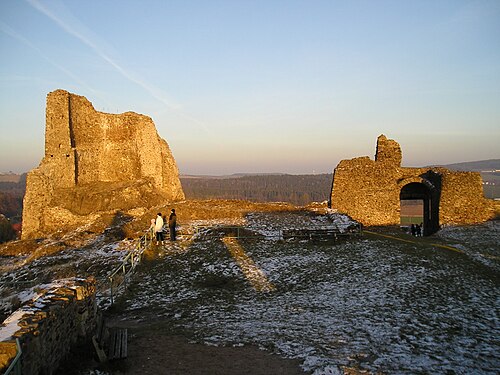 جبال الحديد
مراجع
- ↑ "عدد سكان المناطق المتماسكة والمناطق والمقاطعات في جمهورية التشيك، 1 يناير 2024" . مكتب الإحصاء التشيكي. مؤرشف من الأصل في 17 مايو 2024. تم الاطلاع عليه في 17 مايو 2024 .
- ↑ https://www.czso.cz/csu/xb/regionalni_hdp اللغة: التشيكية، تاريخ الوصول: 30/01/2021
- ↑ "عدد سكان بلديات جمهورية التشيك" . مكتب الإحصاء التشيكي. مؤرشف من الأصل في 30 أبريل 2019. تم الاطلاع عليه في 30 أبريل 2019 .
- ↑The Pardubice RegionArchived 9 July 2007 at the Wayback Machine, Official site, Retrieved 14 April 2011
- ↑"Population of municipalities of the Czech Republic, 1 January 2024". Czech Statistical Office. Archived from the original on 21 June 2024. Retrieved 17 May 2024.
- ↑"Historický lexikon obcí České republiky 1869–2011" (in Czech). Czech Statistical Office. 21 December 2015. Archived from the original on 16 August 2021. Retrieved 27 October 2023.
- ↑"Population Census 2021: Population by sex". Public Database. Czech Statistical Office. 27 March 2021.
- ↑"Historická data – meteorologie a klimatologie". Czech Hydrometeorological Institute. Archived from the original on 14 October 2013. Retrieved 8 September 2013.
- ↑East-Bohemia.info, Official tourist portal of the Pardubice region, Retrieved 8 December 2012
- ↑"Pardubick? Kraj - ?vodn? Strana". Archived from the original on 9 July 2007. Retrieved 8 December 2011.
External links
- Pardubice Region
- Regions of the Czech Republic