
فيليبسدام
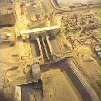
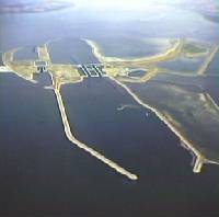
سد فيليبسدام هو سد تقسيم تم بناؤه كجزء من أعمال دلتا في هولندا . يفصل مياه بحيرتي كرامر وفولكيراك عن نهر أوسترسخيلده ، ويربط سد غريفيلينغيندام بسنت فيليبسلاند . [ 1 ]
التاريخ والتصميم والبناء
التصميم والاختيار
الحاجة إلى السد
في عام 1974، قررت هيئة الأشغال العامة (Rijkswaterstaat) ومجلس مدينة دين أويْل إنشاء حاجز أوسترسخيلده (Oosterscheldekering ) كحاجز ضد ارتفاع الأمواج عند مصب نهر أوسترسخيلده، بدلاً من إغلاق مدخل المد والجزر بالكامل في ذلك الموقع. وقد استلزم إنشاء حاجز أوسترسخيلده تقسيم حوض النهر إلى أجزاء. [ 2 ]
تضمن نموذج التقسيم المختار بناء سدي فيليبسدام وأوستردام ، وقناة تصريف لإدارة مستوى ونوعية البحيرة التي ستتشكل خلف السدين. كما تطلب المشروع إنشاء بحيرة مياه عذبة لأغراض إدارة المياه، وضمان الملاحة الخالية من المد والجزر على وصلة نهري شيلدت والراين ، وتحقيق فرق مد وجزر قدره 2.7 متر في يرسيكه . [ 2 ]
دراسة الخيارات والتصميم الأولي
ولتجنب حدوث سرعات تدفق غير مقبولة في قناة شيلدت-راين أثناء أعمال الإنشاء، كان لا بد من تنسيق مراحل إغلاق كل من سد فيليبسدام وسد أوستردام. [ 3 ] وقد دُرست عدة بدائل للموقع النهائي لسد فيليبسدام ومجمع الأقفال، مع إيلاء اعتبار هام للحفاظ على المناطق المدية القيّمة ، بالإضافة إلى دراسة طريقة الإغلاق المُستخدمة. [ 4 ] [ 5 ] [ 6 ]
The decision-making process for the nature and location of the Philipsdam involved a comprehensive consideration of multiple factors, leading to the selection of the variant at a sandbank known as Plaat van de Vliet as the preferred option. Key considerations included:[7] The connection of the dam to the Grevelingendam instead of the southern shore of Goeree-Overflakkee was chosen to allow for the option of turning the Grevelingenmeer into a freshwater basin by feeding it via a discharge sluice from the Krammer, which was ultimately decided against.[8] The benefit of this route is that it also removed the requirement for an additional road bridge across the Krammer instead connecting it to the existing road over the Grevelingendam.[8]
- Hydrology and soil mechanics: The Plaat van de Vliet option was favoured for its hydrological aspects, which were thought to cause minimal disruption to flow speeds in the Krammer during construction. The flow speeds in the Krammer were expected to increase by 20% as long as the Slaak was still open, due to the construction of the work island with salt control basins on the Plaat van de Vliet. The increase in flow speeds along the sandbank known as the Plaat van Oude Tonge was anticipated to be less than 10%. No significant impact was expected on the Zijpe.[9] Soil mechanics considerations favoured an eastern connection to St.-Philipsland to ensure the stability of the dam and minimise ground settlement risks.
| Waterway | Max. Ebb Speed (m/s) | Max. Ebb Volume (m³/s) | Max. Flood Speed (m/s) | Max. Flood Volume (m³/s) |
|---|---|---|---|---|
| Slaak | 0.9 | 2000 | 0.75 | 2000 |
| Krammer | 1.05 | 11000 | 1.05 | 12500 |
- Environmental impact: The decisions on where and how to construct the dam emphasised preserving valuable mudflats and minimising environmental disruption. The Plaat van de Vliet variant, with an eastern connection to St.-Philipsland, was preferred for its ability to preserve a significant portion of valuable mudflats along St.-Philipsland's shore, balancing the need for tidal influence and freshwater impact.[9]
- Water management: The compartmentalisation aimed at separating fresh and saltwater areas, with specific attention to the salt load from the Philipsdam on the future fresh Zoommeer lake. Options for connecting locks to a supply canal to limit salt penetration were also explored.[9]
- الملاحة والنقل: ضمن الخيار المختار مسارًا ملاحيًا واضحًا، وراعى تأثيره على حركة المرور. كما وفر وصولًا مناسبًا إلى وصلة نهري شيلدت والراين، وسمح بفصل مثالي بين الملاحة المهنية والترفيهية. [ 9 ]
- الاعتبارات الترفيهية والزراعية: تم إعطاء الأفضلية للخيارات التي تدعم فرص الترفيه في منطقة زوممير والمناطق المجاورة، والتي تقلل من التأثير على استخدام الأراضي الزراعية والمناظر الطبيعية. [ 10 ]
- الاعتبارات الفنية والتكاليفية: سمح الخيار المختار بإنشاء مجمع أهوسة على جزيرة، مما استلزم تخطيطًا لوجستيًا دقيقًا لضمان سهولة الوصول والإنشاء. لم تُعتبر فروق التكلفة بين البدائل كبيرة، مع تفضيل الحلول التي توفر توازنًا في الفوائد عبر هذه العوامل المختلفة. [ 11 ]
تطلب إنشاء الطريق الرابط على الجانب الجنوبي من السد إجراء بحوث مكثفة خلال مرحلة التصميم، حيث يمر عبر محميات طبيعية معرضة للخطر. [ 12 ]
بناء
بدأ بناء سد فيليبسدام في عام 1976، وذلك بإنشاء جزيرة عمل مؤقتة مساحتها 96 هكتارًا على ضفة رملية تُعرف باسم بلات فان دي فليت . [ 9 ] [ 4 ] [ 13 ] [ 14 ]
بعد ثمانية عشر شهرًا من بدء العمل، اكتمل بناء الجزيرة، مما مهد الطريق لبدء تشغيل الأهوسة التي تهدف إلى تسهيل الملاحة الداخلية واستيعاب اليخوت . وبحلول عام 1983، اكتمل مجمع أهوسة كرامر، وتم افتتاح السد رسميًا في 2 فبراير 1987. وأضيف هويس ثانٍ لليخوت في عام 1994. [ 10 ]
يعمل سد فيليبسدام كسد، وفاصل للمياه العذبة عن المياه المالحة، ونظام أهوسة. وهو يخفف من تأثيرات المد والجزر ضمن وصلة نهري شيلدت والراين، مما يضمن بقاء ميناء أنتويرب مفتوحًا. تقع المياه المالحة غرب السد، بينما تتدفق المياه العذبة من نهري فال وبيرجس ماس شرقه . [ 10 ]
يُحافظ على مستوى مياه نهر أوسترسخيلده في الجانب المالح من السد، مما يضمن الحفاظ على المستنقعات المالحة والمسطحات الطينية الضرورية لتربية المحار . أما الجانب العذب، فيدعم غطاءً نباتيًا كثيفًا نظرًا لظروفه الأكثر جفافًا. ويُسهّل وجود مجمع أهوسة مرور السفن، إذ يتميز بنظام مبتكر لفصل المياه العذبة عن المالحة. [ 11 ] [ 9 ] [ 10 ]
In addition to the main road over the crest of the dam, there is a parallel road on its eastern side which was constructed to offer access to recreational zones. The dam's southern route was deliberately positioned as far west as possible from the Plaat van Vliet and Krammerse Slikken, maximising the recreational potential of these mudflats. Efforts were made to preserve the ecological and tidal areas of the Slaak (the region between the dam and the northern side of Sint Philipsland), while minimising the impact on agricultural land in Sint Philipsland.[10] The Krammer wind farm is located around the dam.[15][16]

Locks
The locks are technically sophisticated because they must avoid the exchange between the freshwater Volkerak and the brackish water of the Oosterschelde. The locks are designed so that there is no influx of saltwater that enters the Volkerak and only a little fresh water in the Oosterschelde. The locks rely on the physical principle that saltwater is denser and sinks, while freshwater rises. By a complex system of pipes and pumps, the saltwater is pumped from the bottom, or conversely, freshwater is pumped from the top, depending on the direction of the ship. Locks on inland waterways are 280 metres long and 24 metres wide.[5]
Environmental impacts
The dam considerably changed the surrounding landscape. Shortly after closure, the water became fresh and the level in the Krammer-Volkerak was fixed at zero centimeters NAP (Amsterdam Ordnance Datum). As a result, nearly two thousand hectares of salt marshes, mudflats, and sandflats permanently dried out. Shoreline erosion was mitigated by constructing foreshores. In the 1990s, around forty islands were created that are of great importance for coastal breeding birds, meaning that the alluvialtidal marsh now supports rich animal life. An observation hut was installed to facilitate the observation of the many species of birds, such as the pied avocet.[10]

See also
References
- ↑"Krammersluizen en Philipsdam"[The Krammer Sluices and the Philipsdam]. www.rijkswaterstaat.nl (in Dutch). 29 December 2022. Retrieved 29 December 2022.
- 12Compartimenteringswerken[Compartmentalisation Works] (in Dutch). The Hague: Rijkswaterstaat. 1980. Retrieved 4 April 2024.
- ↑van Wijngaarden, N.J.; Hartsuiker, G.; Agema, J.F. (1977). Compartimentering Oosterschelde – getijmodel Oosterschelde : onderzoek naar de fasering bij de aanleg van de Philipsdam en de Oesterdam bij gereduceerd getij interim-verslag modelonderzoek[Compartmentalisation of the Eastern Scheldt – Eastern Scheldt tidal model: Research into the phasing during the construction of the Philipsdam and the Oesterdam with reduced tide. Interim report on model research.] (Report) (in Dutch). Rijkswaterstaat. Retrieved 4 April 2024.
- 12"Het rapport van de Commissie Compartimentering Oosterschelde"[The Report of the Eastern Scheldt Compartmentalization Commission]. Driemaandelijks Bericht Deltawerken (in Dutch). 8e tiental (73): blz 111–114. August 1975. Retrieved 29 March 2024.
- 12Watson, I.; Finkl, C. W. (1990). "State of the Art in Storm-Surge Protection: The Netherlands Delta Project". Journal of Coastal Research. 6 (3): 739–764. ISSN 0749-0208. JSTOR 4297737. Retrieved 29 March 2024.
- ↑van Roode, F.C.; Tutuarima, W.H.; Brakel, J.; Groothuizen, A.G.M. (1979). Beschouwing naar aanleiding van "de interimnota nr. 2" : fasering en sluitmethode Compartimenteringsdammen[Reflections on "Interim Note No. 2": Phasing and Closure Method of Compartmentalisation Dams] (Report) (in Dutch). Rijkswaterstaat. Retrieved 4 April 2024.
- ↑Huis in 't Veld, J. C.; Stuip, J.; Walther, A.W.; van Westen, J.M. (1987). The Closure of tidal basins: closing of estuaries, tidal inlets, and dike breaches (2nd ed.). Delft, the Netherlands: Delft University Press. ISBN 90-6275-287-X. OCLC 18039440. Retrieved 29 March 2024.
- 12"Philipsdam". WatersnoodMuseum. Stichting Beheer Watersnoodmuseum. Retrieved 9 April 2024.
- 1 2 3 4 5 6 "De Regeringsbeslissing over de afsluiting van de Oosterschelde" [ قرار الحكومة بشأن إغلاق منطقة شيلدت الشرقية ] . Driemaandelijks Bericht Deltawerken (باللغة الهولندية). 8e تيانتال (71): بلز 3-5. فبراير 1975 . تم الاسترجاع في 29 مارس 2024 .
- 1 2 3 4 5 6 ستينهويس، م.؛ فورمان، ل. (2016). De Deltawerken [ أعمال الدلتا ] (باللغة الهولندية). روتردام: nai010 uitgevers. رقم ISBN 978-94-6208-272-4.
- 1 2 أنونيموس، أ. (1975). "Driemaandelijks bericht Deltawerken 071-080 (1975–1979)" [ النشرة ربع السنوية لـ Deltaworks 071-080 (1975–1979) ] . Driemaandelijks Overzicht van de Deltawerken (Deltaplan) en Gerelateerde Werken (Dijkversterkingen في هولندا، فريزلاند إن جرونينجن، Lauwerszeewerken). Aanleg Stormvloedkeringen Hollandse IJssel en Oosterschelde. Afsluitdammen Met Caissons en Kabelbaan in Veerse Gat، Brouwershavense Gat، Oosterscheldewerken، Spuisluis Haringvliet، Waterhuishouding van het Deltagebied، Milieueffecten. De Secundaire Werken (Vokerak، Grevelingen، Zandkreek، Zoommeer، Philipssluizen، Krammersluizen، Hellegatsplein). Waterloopkundig Onderzoek وطريقة Uitvoerings. (بالهولندية) ( 71–080 ) . تم الاسترجاع 29 ديسمبر 2022 – عبر TU Delft.
- ^ أنونيموس أ. (1977). "Driemaandelijks bericht Deltawerken 081-090 (أغسطس 1977 - نوفمبر 1979)" [ نشرة ربع سنوية لـ Delta Works: 081-090 (أغسطس 1977 - نوفمبر 1979) ] . النشرة الربع سنوية لأعمال الدلتا (باللغة الهولندية) ( 81-090 ) . تم الاسترجاع في 29 ديسمبر 2022 – عبر TU Delft Repository.
- ^ Aanleg werkeiland Philipsdam [ إنشاء جزيرة عمل فيليبسدام ] (أبلغ عن) (باللغة الهولندية). هاردينكسفيلد، هولندا: Baggermaatschappij Holland BV.
- ^ باجيرماتشابيج هولاند (1980). إنشاء جزيرة صناعية – فيليبسدام . هاردينكسفيلد: باجيرماتشابيج هولندا . تم الاسترجاع في 4 أبريل 2024 .
- ↑ "محطة طاقة الرياح كرامر - غرين تراست" . غرين تراست . تم الاطلاع عليه بتاريخ 28 فبراير 2026 .
- ^ "ويندبارك كرامر" . ويندبارك كرامر . تم الاسترجاع في 1 مارس 2026 .
روابط خارجية
معلومات (باللغة الهولندية) عن فيليبسدام من موقع مركز المعرفة التابع لمتحف ووترسنود.
- السدود في زيلاند
- السدود في جنوب هولندا
- تم الانتهاء من بناء السدود في عام 1987
- دلتا ووركس
- جويري-أوفرفلاكي
- ثولين