
Vyttila

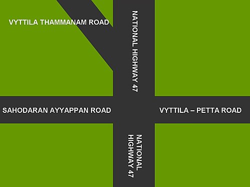
Vyttila, IPA:[ʋɐjt̺ːilɐ], is a region in the city of Kochi, Kerala.[1] It is a prominent area located in southern Kochi. The Vyttila junction is the busiest as well as the largest intersection in Kerala.[2] This node intersects the main north–south artery of the state of Kerala, namely, the Kochi Bypass, with three city roads of Kochi viz, the S. A. Road (One of the city's most prominent arterial road in the east–west direction), the Vyttila-Petta Road, and the Thammanam Road.
The name Vyttila is said to be evolved from the word "Vayal Thala" meaning the main part of the paddy field. Once the area including Elamkulam, were paddy fields and paddy cultivation were the main sources of income. The paddy field existed from Ernakulam, Girinagar, Panampilly Nagar, Gandhi Nagar, Jawahar Nagar, Kumarananshan Nagar and extended to Kaniyampuzha and Panamkutyy bridge. Some also say that because there existed a bunch of dacoits, who murdered and looted the travelers the name evolved from 'Vazhithala'. Once the Puthenpalam bridge that connected Chilavennoor Lake and Chettichira was the only link from Vayalthala with Ernakulam.
Vyttila hosts the Vyttilla Mobility Hub, which converges different ways of surface transport (namely, local as well as long-distance buses, rail, Metro Rail and inland water transport) to the city onto a single node.[3]
Vyttila is also the name of the region in the city of Kochi, of which the Vyttila Intersection is a part. Until 1967, Vyttila was a panchayat. The November 1967 order of the Kerala Legislative Assembly amalgamated Vyttila to the newly formed Kochi Corporation.

Vyttila Mobility Hub

Vyttila is home for the Vyttila Mobility Hub, which converges different modes of surface transport (namely, local as well as long-distance buses, rail, Metro Rail and inland water transport) to the city of Kochi onto a single node. Phase-1 of the project consists of a Bus Terminal with 13 bus bays, each of which can park 5 buses.[4] Thus, when Phase-1 is completed, the terminal can handle as many as 65 buses at a time.[4] Part of the proposed Phase-1 was commissioned on 26 February 2011.[5][3] well before completion of the phase, owing to a political decision to inaugurate the terminal before declaration of the State Election which is anticipated on 1 March 2011. What was so far was commissioned consists of 4 of the proposed 13 bus bays. 3 more bus bays are presently under construction. The mobility hub is located north-east of the Vyttila Intersection, in the area between Kaniyampuzha Road and Poonithura Village Office. Vyttila is the node of the city that connects it to the neighbouring districts viz, Thrissur, Alappuzha, Kottayam and Idukki.
Kochi Bypass
The Aroor-Edapally streatch of the National Highway 66, even though built a couple of decades back, as a highway, to by-pass the city of Kochi, has now become a busy city road, necessitating the construction of a newer by-pass, a little more eastward to the city (which is already proposed in the Kochi Master Plan).
The Vytilla Junction on the bypass is the biggest and busiest road intersection in the state. It connects the district headquarters of Kottayam, Alleppey etc. to the Kochi city centre. Vyttila flyover was opened in 2021.

Health and education

Vyttila is home to hospitals like the Welcare Hospital and the Mother & Child Hospital. Toc H Public School, St. Rita's H.S Ponnurunni, C.K.C.L.P.S are schools located in Vyttila.
Schools
Vyttila hosts the following schools:
- Toc H Public School
- C.K.C Girls High School, Ponnurunni
- St. Rita's High School, Ponnurunni
- Nalanda Public School Thammanam
كليات اللغات الأجنبية
- أكاديمية تراوم للغتين الألمانية والفرنسية
- مينون
أماكن العبادة
- معبد سري نارايانيشوارام، بونوروني
- معبد كافالامبيليل نيلينجاتو باجافاثي
- معبد فيتيلا سيفا سوبرامونيا
- معبد أيامبيليكافو ديفي
- معبد كافالامبيللي دارما دايفا، طريق جونيور جاناتا
- كنيسة القديس باتريك، فيتيلا
- كنيسة القديس رافائيل، ثيكودام
- كنيسة القديس غريغوريوس الأرثوذكسية السريانية، طريق شاين، فيتيلا
- كنيسة سيدة الصحة، تشاليكافاتوم
- مزار القديس يوسف، الطريق الرئيسي
- كنيسة زمالة شارون، مقابل. KSEB معطلة، فيتيللا.
- كنيسة شارون فيلوشيب، ثيكودام.
- كنيسة إغناطيوس نورونو اليعقوبية، بونوروني
- مسجد تشاليكافاتوم الجامع
- مسجد الجمعة عرور
- مسجد سلفي، فيتيلا
المناطق المجاورة
تقع جاناتا، ومحطة توليد الطاقة، وثايكودام، وكانيامبوزا، وبونوروني جميعها على مقربة من فيتيلا. أصبحت فيتيلا الآن منطقة تجارية في المقام الأول، إلا أن المنطقة المحيطة بالتقاطع لا تزال مكتظة بالسكان.
تمتلئ الطرق والأزقة على جانبي طريق SA والطريق السريع الوطني بالمباني السكنية. وتوجد جمعيات سكانية لكل منطقة في فيتيلا، وتُعد جمعية فيتيلا لرعاية السكان من أبرزها. وتغطي هذه الجمعية، التي يقع مقرها في طريق مابلاتشيري، كامل المنطقة الجنوبية الغربية من تقاطع فيتيلا، ويحدها طريق مابلاتشيري وطريق بنك.
مراجع
- ↑ " مؤسسة بلدية كوتشين - الأحياء" . www.kochicorporation.lsgkerala.gov.in
- ↑ مراسل صحفي (7 أبريل 2018). "ازدحام مروري غير مسبوق في فيتيلا" . صحيفة ذا هندو . ISSN 0971-751X . تاريخ الاطلاع: 5 مايو 2018 .
- 1 2 "أخبار الأرشيف" . صحيفة ذا هندو .
- 1 2 مترو مانوراما، 26 فبراير 2011، ص3
- ↑ "افتتاح المرحلة الأولى من مركز فيتيلا للتنقل" . مؤرشف من الأصل بتاريخ 24 ديسمبر 2013.
روابط خارجية
- http://www.kerala.gov.in//ernaks/agri.htm الموقع الرسمي لحكومة ولاية كيرالا - صفحة إدارة الزراعة، مع عنوان مكتب الزراعة في فيتيلا
- https://web.archive.org/web/20090814235404/http://www.tochschool.com/secmenudisp.php?MID=62 موقع مدرسة توخ العامة (فيتيلا) - صفحة موقع المدرسة مع خريطة الطريق من مفترق فيتيلا
- https://web.archive.org/web/20110202195045/http://vytilla.com/
- http://www.india9.com/i9show/Vytilla-68972.htm
- صحيفة ذا هندو: اقتراح إنشاء مركز نقل في فيتيلا
- http://article.wn.com/view/2010/01/22/Decks_cleared_for_Vytilla_bus_terminal/
- صحيفة ذا هندو: مركز فيتيلا يخدم المصلحة العامة
- http://www.keraladaily.net/index.php?mod=article&cat=keralanews&article=941 مؤرشف بتاريخ 3 مارس 2016 في أرشيف الإنترنت (Wayback Machine)
- أحياء في كوتشي