
Valles Caldera
The Valles Caldera (or Jemez Caldera) is a 13.7-mile-wide (22.0 km)volcaniccaldera in the Jemez Mountains of northern New Mexico.[1]Hot springs, streams, fumaroles, natural gas seeps, and volcanic domes dot the caldera landscape.[5] The highest point in the caldera is Redondo Peak, an 11,254-foot (3,430 m)resurgent lava dome located entirely within the caldera and surrounded by moat-like flows of rhyolitic solidified lavas.[6] Located within the caldera are several grass valleys, or valles, the largest of which is Valle Grande (locally /ˈvaɪ.eɪˈɡrɑːndeɪ/VY-ay GRAHN-day), the only one accessible by a paved road. In 1975, Valles Caldera was designated as a National Natural Landmark by the National Park Service with much of the caldera being within the Valles Caldera National Preserve, a unit of the National Park System.[7] The area has a varied history involving cultural significance, economic resources, scientific studies, and complex geological setting.
History
Use of Valles Caldera dates back to prehistoric times: spear points dating to 11,000 years ago have been discovered.[8] Several Native American tribes frequented the caldera for hunting prolific game and gathering obsidian that is common in this area. The obsidian was knapped into tools and weapons while wild game was followed and hunted seasonally. Obsidian from the caldera was traded by tribes across much of the Southwest. Eventually, the Spanish, and later Mexican settlers along with the Navajo and other tribes came to the caldera seasonally for grazing livestock. This often resulted in periodic clashes and raids between tribes and cultures. Later, as the United States acquired New Mexico as part of the Treaty of Guadalupe Hidalgo in 1848, the caldera became the backdrop for the Indian wars with the U.S. Army. Around the same time, the caldera and its forests began to be used commercially for ranching and logging.
Baca Ranch
The caldera became part of the Baca Ranch in 1876. The Bacas were a wealthy family given the land as compensation for the termination of a grant given to their family near Las Vegas, in northeastern New Mexico. The family was given four other parcels by the US Government as well, another one in New Mexico, one in Colorado, and two in Arizona. This area, 100,000 acres (40,000 ha), was called Baca Location Number One or Baca Float Number One. Since then, the land has been through a string of exchanges between private owners and business enterprises. It was owned by Frank Bond in the 1930s. Bond, a businessman based in nearby Española, ran up to 30,000 sheep in the caldera, significantly overgrazing the land and causing damage from which the watersheds of the landscape are still recovering.
The land was purchased by the Dunigan family from Abilene, Texas in 1963. Pat Dunigan did not obtain the timber rights and the New Mexico Lumber Company logged the property heavily - removing significant amounts of old-growth douglas fir and ponderosa pine. Dunigan bought out the timber rights in the 1970s and slowed the logging. He negotiated unsuccessfully with the National Park Service and the US Forest Service for possible sale of the property in the 1980s.[8]

Valles Caldera National Preserve
أنشأ قانون حماية وادي كالديرا لعام 2000، الذي وقّعه الرئيس كلينتون في 25 يوليو/تموز 2000، محمية وادي كالديرا الوطنية. [ 9 ] نصّ القانون على شراء الحكومة الفيدرالية لهذه المزرعة التاريخية بأموال من صندوق الحفاظ على الأراضي والمياه ، المُستمدة من العائدات التي تتلقاها الحكومة الأمريكية من التنقيب عن النفط والغاز الطبيعي في المياه الإقليمية . [ 5 ] باعت عائلة دانيغان كامل مساحة الأرض البالغة 95,000 فدان (380 كيلومترًا مربعًا ) وسبعة أثمان من حقوق المعادن الحرارية الأرضية للحكومة الفيدرالية مقابل 101 مليون دولار. ولأن بعض مواقع مزرعة باكا مقدسة وذات أهمية ثقافية للسكان الأصليين ، فقد مُنحت 5,000 فدان (20 كيلومترًا مربعًا ) من الأرض المشتراة لقبيلة سانتا كلارا بويبلو ، التي تُجاور المزرعة من الشمال الشرقي. وتشمل هذه المواقع منابع نهر سانتا كلارا، وهو نهر مقدس لدى القبيلة. [ 5 ] [ 8 ] في الركن الجنوبي الغربي من الأرض، كان من المقرر التنازل عن 300 فدان (1.2 كم 2 ) إلى النصب التذكاري الوطني بانديلير .
كانت مزرعة باكا، المعروفة أيضًا باسم موقع باكا رقم 1، تضم مجموعة متنوعة من أنواع الأشجار وتنوعًا بيولوجيًا كبيرًا . عند شرائها، كانت المزرعة موطنًا لـ 64 كيلومترًا من جداول سمك السلمون المرقط النقية ، و26,757 هكتارًا من غابات الصنوبر ، و17 نوعًا من النباتات والحيوانات المهددة بالانقراض، و 10,000 هكتار من المراعي التي ترعى فيها 8,000 من الأيائل ، وهي أكبر قطيع في نيو مكسيكو. وتحيط بالمحمية أراضٍ فيدرالية، بما في ذلك غابة سانتا فيه الوطنية ، ومنطقة جيميز الوطنية الترفيهية ، ونصب بانديلير التذكاري الوطني . [ 10 ]
The Valles Caldera Preservation Act of 2000 also created the Valles Caldera Trust, an experimental management organization consisting of nine board members, including seven appointed by the President of the United States.[11] The Trust combined private-sector practices with federal land management protocol. Under the terms of the Valles Caldera Preservation Act, the preserve was to become financially self-sustaining by 2015.
Environmentalists lobbied for the more inclusive protections of national park status instead of the Trust model, but then-Senator Pete Domenici (R) insisted on the experimental approach as a condition for his support for public purchase. Beginning in 2010, US Senator Jeff Bingaman (D) introduced legislation that would transfer the property to the National Park Service as a national preserve.[12] The 2011 bill[13] was supported by the VCNP trustees and a majority of New Mexico's Congressional delegation. On December 19, 2014, President Barack Obama signed the 2015 National Defense Authorization Act, which transferred administrative jurisdiction of the preserve from the Valles Caldera Trust to the National Park Service.[14] After a brief transition period, the National Park Service assumed day-to-day management on October 1, 2015. On October 10, the preserve held an official dedication with dignitaries including U.S. Secretary of the Interior Sally Jewell, U.S. Senator Tom Udall, U.S. Senator Martin Heinrich, former U.S. Senator Jeff Bingaman, National Park Service Intermountain Region Director Sue Masica, and the first National Park Service Superintendent of Valles Caldera National Preserve, Jorge Silva-Bañuelos.[15]
Las Conchas Fire
In July 2011, the Las Conchas Fire, started by a power line on nearby private land, burned 30,000 acres (120 km2) of the Valles Caldera National Preserve. The wildfire burned a total of 156,000 acres (630 km2) in the Jemez Mountains, including most of neighboring Bandelier National Monument.[16] The Jemez Mountains and surrounding areas of the southwest incorporate dry climates, grasslands, and certain tree species (like Pinon) that evolved to exist with wildfires. Changes in climate and anthropogenic interference with the fire cycle and habitats, has led to fires that are hotter and more intense. These types of fires are more difficult for ecosystems to recover from.
Geoscience


The circular topographic rim of the caldera measures 13.7 miles (22.0 km) in diameter.[1] The caldera and surrounding volcanic structures are one of the most thoroughly studied caldera complexes in the United States. Research studies have focused on the fundamental processes of magmatism, hydrothermal systems, ore deposition, and glassy rhyolites.[17] Nearly 40 deep cores have been examined, resulting in extensive subsurface data and geothermal information.
Valles Caldera is the younger of two calderas known at this location, having collapsed over and buried the older Toledo Caldera, which in turn may have collapsed over yet older calderas. The associated Cerros del Rio volcanic field, which forms the eastern Pajarito Plateau and the Caja del Rio, is older than the Toledo Caldera. The Toledo and Valles Calderas formed during eruptions 1.61 million and 1.25 million years ago, respectively.[18][19] The caldera-forming Toledo eruption emplaced the Otowi member of the Bandelier Tuff 1.61 million years ago, which can be seen along canyon walls west of Valles Caldera, including San Diego Canyon. The younger Tshirege Member of the Bandelier Tuff was formed during the Valles Caldera eruption 1.23 million years ago.[2] The now eroded and exposed orange-tan, light-colored Bandelier Tuff from these events creates the stunning mesas of the Pajarito Plateau.
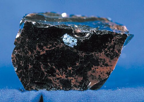
كالديرا هي الموقع النموذجي لكالديرا القبة المتجددة ، والتي طُوِّر تكوينها لأول مرة على يد سي إس روس، وآر إل سميث، وآر إيه بيلي خلال أعمال ميدانية في فاليس في ستينيات القرن الماضي. [ 20 ] استُخدم هذا الموقع النموذجي والدراسات المرتبطة به لدراسة قباب متجددة أخرى حول العالم، بما في ذلك كالديرا يلوستون . بعد الثوران الأولي المُشكِّل للكالديرا في فاليس، ارتفعت قبة ريدوندو بيك المتجددة بدءًا من حوالي 1.2 مليون سنة مضت. [ 2 ] حدثت ثورات بركانية طفيفة لتدفقات الريوليت في الخندق من حوالي 1.16 مليون سنة مضت في سيرو ديل ميديو إلى 0.07 مليون سنة مضت في بانكو بونيتو، على طول منطقة صدع حلقي بنيوي. [ 21 ] [ 22 ] [ 23 ] تشكلت صخور الخفاف في إل كاخيتي وصخور الإغنمبريت في باتلشيب روك خلال حدث بركاني واحد قبل 74200 ± 1100 عام، تلاه ثوران تدفق الأوبسيديان في بانكو بونيتو خلال أحدث ثوران بركاني في كالديرا فالييس، قبل 68900 ± 1000 عام. [ 2 ] لا تزال الكالديرا والمنطقة المحيطة بها تتأثر بالنشاط البركاني المستمر. تُظهر الدراسات الزلزالية وجود منطقة منخفضة السرعة أسفل الكالديرا، مما يشير إلى وجود انصهار جزئي داخل حجرة صهارة متبقية على عمق يتراوح بين 5 و15 كيلومترًا. [ 24 ] يوجد اليوم نظام حراري أرضي نشط مع ينابيع حارة وفوهات بركانية . [ 1 ] تقع هذه الكالديرا والهياكل البركانية المرتبطة بها ضمن حقل جيميز البركاني . يقع هذا الحقل البركاني عند ملتقى صدع ريو غراندي ، الذي يمتد من الشمال إلى الجنوب عبر نيو مكسيكو، وخط جيميز ، الذي يمتد من جنوب شرق أريزونا شمال شرقًا إلى غرب أوكلاهوما . ويرتبط النشاط البركاني هنا بالحركات التكتونية لهذا الملتقى. [ 25 ]
استخدمت وكالة ناسا فوهة البركان في الفترة من أكتوبر إلى نوفمبر 1964، ثم مرة أخرى في سبتمبر 1966، لتدريب رواد فضاء أبولو جيولوجيًا على التعرف على السمات البركانية، مثل تدفقات الرماد البركاني، وشلالات الخفاف، وقباب الريوليت. وكان من بين أبرز المدربين الجيولوجيين روي بيلي. [ 26 ]

مناخ
بحسب تصنيف كوبن للمناخ ، تتمتع كالديرا فاليس بمناخ شبه قطبي (Dfc)، حيث الشتاء بارد والصيف معتدل. وتتعرض الكالديرا لانعكاسات حرارية قوية، مما يتسبب في ليالٍ شديدة البرودة على مدار العام وتفاوت كبير في درجات الحرارة بين الليل والنهار.
| بيانات المناخ لمنطقة لوس ألاموس 13 غرب، نيو مكسيكو، 1991-2020 المعدلات الطبيعية: 8716 قدمًا (2657 مترًا) | |||||||||||||
|---|---|---|---|---|---|---|---|---|---|---|---|---|---|
| شهر | يناير | فبراير | مار | أبريل | يمكن | يونيو | يوليو | أغسطس | سبتمبر | أكتوبر | نوفمبر | ديسمبر | سنة |
| أعلى درجة حرارة مسجلة بالفهرنهايت (°مئوية) | 57 (14) | 56 (13) | 65 (18) | 72 (22) | 77 (25) | 88 (31) | 88 (31) | 84 (29) | 82 (28) | 74 (23) | 67 (19) | 59 (15) | 88 (31) |
| متوسط درجة الحرارة القصوى بالفهرنهايت (°مئوية) | 48.8 (9.3) | 49.6 (9.8) | 58.8 (14.9) | 65.2 (18.4) | 71.9 (22.2) | 81.3 (27.4) | 80.9 (27.2) | 77.1 (25.1) | 74.2 (23.4) | 68.1 (20.1) | 61.2 (16.2) | 52.7 (11.5) | 82.3 (27.9) |
| متوسط درجة الحرارة العظمى اليومية (فهرنهايت/مئوية) | 36.2 (2.3) | 38.2 (3.4) | 44.5 (6.9) | 52.4 (11.3) | 62.0 (16.7) | 71.7 (22.1) | 73.7 (23.2) | 71.1 (21.7) | 65.7 (18.7) | 56.5 (13.6) | 45.5 (7.5) | 36.4 (2.4) | 54.5 (12.5) |
| متوسط درجة الحرارة اليومية بالفهرنهايت (°مئوية) | 22.5 (-5.3) | 25.2 (−3.8) | 32.0 (0.0) | 38.9 (3.8) | 46.9 (8.3) | 55.6 (13.1) | 59.3 (15.2) | 57.2 (14.0) | 50.6 (10.3) | 41.4 (5.2) | 31.2 (−0.4) | 22.7 (−5.2) | 40.3 (4.6) |
| متوسط الحد الأدنى اليومي بالدرجة فهرنهايت (°مئوية) | 8.7 (−12.9) | 12.1 (−11.1) | 19.5 (-6.9) | 25.4 (−3.7) | 31.8 (−0.1) | 39.4 (4.1) | 45.0 (7.2) | 43.3 (6.3) | 35.5 (1.9) | 26.4 (−3.1) | 16.9 (−8.4) | 9.0 (-12.8) | 26.1 (−3.3) |
| متوسط الحد الأدنى للدرجة فهرنهايت (°مئوية) | -12.6 (-24.8) | -8.5 (-22.5) | 0.9 (−17.3) | 10.1 (-12.2) | 19.2 (-7.1) | 29.1 (−1.6) | 37.2(2.9) | 35.2(1.8) | 25.4(−3.7) | 13.1(−10.5) | −0.5(−18.1) | −12.6(−24.8) | −18.4(−28.0) |
| Record low °F (°C) | −24(−31) | −26(−32) | −14(−26) | 2(−17) | 10(−12) | 22(−6) | 32(0) | 30(−1) | 19(−7) | −2(−19) | −9(−23) | −26(−32) | −26(−32) |
| Average precipitation inches (mm) | 1.76(45) | 1.98(50) | 2.35(60) | 1.76(45) | 1.39(35) | 1.15(29) | 3.68(93) | 3.66(93) | 2.18(55) | 2.17(55) | 1.63(41) | 1.77(45) | 25.48(646) |
| Source 1: NOAA[27] | |||||||||||||
| Source 2: XMACIS2 (records & monthly max/mins)[28] | |||||||||||||
| Climate data for Wolfcanyon, New Mexico, 1991–2020 normals, 1912–2020 extremes: 8220ft (2505m) | |||||||||||||
|---|---|---|---|---|---|---|---|---|---|---|---|---|---|
| Month | Jan | Feb | Mar | Apr | May | Jun | Jul | Aug | Sep | Oct | Nov | Dec | Year |
| Record high °F (°C) | 63(17) | 69(21) | 75(24) | 78(26) | 86(30) | 95(35) | 99(37) | 96(36) | 91(33) | 80(27) | 74(23) | 68(20) | 99(37) |
| Mean maximum °F (°C) | 50.7(10.4) | 50.8(10.4) | 59.2(15.1) | 66.4(19.1) | 74.4(23.6) | 82.9(28.3) | 83.7(28.7) | 80.2(26.8) | 77.1(25.1) | 69.7(20.9) | 59.7(15.4) | 51.2(10.7) | 85.0(29.4) |
| Mean daily maximum °F (°C) | 38.2(3.4) | 40.1(4.5) | 47.8(8.8) | 55.8(13.2) | 64.7(18.2) | 75.3(24.1) | 77.0(25.0) | 74.7(23.7) | 69.2(20.7) | 58.8(14.9) | 46.6(8.1) | 38.0(3.3) | 57.2(14.0) |
| Daily mean °F (°C) | 23.7(−4.6) | 26.4(−3.1) | 33.3(0.7) | 39.9(4.4) | 47.3(8.5) | 56.1(13.4) | 60.4(15.8) | 58.8(14.9) | 52.6(11.4) | 42.8(6.0) | 32.1(0.1) | 24.1(−4.4) | 41.5(5.3) |
| Mean daily minimum °F (°C) | 9.3(−12.6) | 12.7(−10.7) | 18.8(−7.3) | 24.0(−4.4) | 29.9(−1.2) | 36.9(2.7) | 43.7(6.5) | 42.9(6.1) | 36.1(2.3) | 26.7(−2.9) | 17.6(−8.0) | 10.1(−12.2) | 25.7(−3.5) |
| Mean minimum °F (°C) | −9.2(−22.9) | −6.0(−21.1) | 0.3(−17.6) | 10.8(−11.8) | 19.9(−6.7) | 27.4(−2.6) | 36.0(2.2) | 35.3(1.8) | 24.8(−4.0) | 13.7(−10.2) | 0.2(−17.7) | −9.3(−22.9) | −13.6(−25.3) |
| Record low °F (°C) | −38(−39) | −41(−41) | −26(−32) | −12(−24) | 5(−15) | 14(−10) | 18(−8) | 22(−6) | 11(−12) | −2(−19) | −29(−34) | −34(−37) | −41(−41) |
| Average precipitation inches (mm) | 1.89(48) | 1.67(42) | 1.66(42) | 1.33(34) | 1.15(29) | 0.90(23) | 3.35(85) | 3.35(85) | 2.12(54) | 1.75(44) | 1.51(38) | 1.90(48) | 22.58(572) |
| Average snowfall inches (cm) | 22.8(58) | 20.1(51) | 16.8(43) | 11.9(30) | 2.2(5.6) | 0.1(0.25) | 0.0(0.0) | 0.0(0.0) | 0.2(0.51) | 3.5(8.9) | 11.4(29) | 22.3(57) | 111.3(283.26) |
| Source 1: NOAA[29] | |||||||||||||
| Source 2: XMACIS2 (records & monthly max/mins)[28] | |||||||||||||
| Climate data for Hidden Valley (Valles Caldera), New Mexico (2011–2023): 8,470 ft (2,580 m) | |||||||||||||
|---|---|---|---|---|---|---|---|---|---|---|---|---|---|
| Month | Jan | Feb | Mar | Apr | May | Jun | Jul | Aug | Sep | Oct | Nov | Dec | Year |
| Record high °F (°C) | 59.1(15.1) | 57.9(14.4) | 66.6(19.2) | 72.9(22.7) | 76.0(24.4) | 90.0(32.2) | 85.0(29.4) | 82.5(28.1) | 83.2(28.4) | 74.8(23.8) | 68.0(20.0) | 64.2(17.9) | 90.0(32.2) |
| Mean daily maximum °F (°C) | 37.9(3.3) | 40.4(4.7) | 48.0(8.9) | 54.5(12.5) | 62.5(16.9) | 74.9(23.8) | 75.5(24.2) | 73.6(23.1) | 69.1(20.6) | 58.2(14.6) | 48.5(9.2) | 38.2(3.4) | 56.8(13.8) |
| Daily mean °F (°C) | 16.4(−8.7) | 22.4(−5.3) | 31.8(−0.1) | 38.9(3.8) | 45.7(7.6) | 55.7(13.2) | 58.3(14.6) | 55.6(13.1) | 49.5(9.7) | 37.7(3.2) | 27.4(−2.6) | 18.3(−7.6) | 38.1(3.4) |
| Mean daily minimum °F (°C) | −3.5(−19.7) | 2.3(−16.5) | 13.6(−10.2) | 18.9(−7.3) | 22.7(−5.2) | 29.6(−1.3) | 39.2(4.0) | 37.0(2.8) | 29.5(−1.4) | 17.3(−8.2) | 8.4(−13.1) | −1.1(−18.4) | 17.8(−7.9) |
| Record low °F (°C) | −39.6(−39.8) | −39.0(−39.4) | −23.1(−30.6) | −2.3(−19.1) | −1.1(−18.4) | 8.4(−13.1) | 20.7(−6.3) | 20.9(−6.2) | 7.7(−13.5) | −14.7(−25.9) | −19.9(−28.8) | −39.6(−39.8) | −39.6(−39.8) |
| Average precipitation inches (mm) | 1.13(29) | 0.71(18) | 2.10(53) | 0.63(16) | 0.91(23) | 1.07(27) | 4.01(102) | 2.61(66) | 2.50(64) | 2.08(53) | 1.16(29) | 0.91(23) | 19.82(503) |
| Average precipitation days (≥ 0.01 in) | 8.9 | 7.7 | 9.9 | 7.7 | 8.1 | 5.8 | 16.1 | 14.7 | 10.6 | 9.1 | 9.1 | 7.7 | 115.4 |
| Source: WRCC[30] | |||||||||||||
Geothermal energy exploration
The volcanic properties of Valles Caldera make it a likely source for renewable geothermal energy. Some people oppose the development of geothermal energy, considering it destructive to the scenic beauty, recreational and grazing use. Its impact on the hot springs and supplying aquifers is unknown as experiences from other past geothermal projects proved that production of reservoir fluids had dramatic impacts to the surface thermal features.[31]

Valles Caldera was home to the first experiments into development of an Enhanced geothermal system (EGS) or Hot-dry-rock (HDR) geothermal system, beginning in 1974 by the Los Alamos National Laboratory at the Fenton Hill reservoir, approximately 3 km west of Valles Caldera. Originally, the Fenton Hill site was chosen as an EGS laboratory in hopes that the proximity to Valles Caldera would increase the temperature of the bedrock, thus requiring shallower drill depths. The abundance of hydrothermal fluids discharged from the nearby caldera resulted in hydrothermal alteration of the rocks at depth, weakening the sealed nature of the reservoir.[32] The Fenton Hill HDR experiment was finally abandoned in 1998.[33] The experiments demonstrated that a potential EGS reservoir must be characterized by low permeability, crystalline basement rock with no active faults or joints.[32]
From 1959 to 1983, approximately 40 exploratory geothermal wells were drilled into the Redondo Creek Graben as part of the Baca geothermal field, a joint operation by the United States Department of Energy and the Union Oil Company of California.[34] Despite measuring a maximum temperature of 342 °C and having a likely production capacity of 20 MWe, the geothermal field was too small to be economic.[33][35] Three scientific cores were drilled in Valles Caldera during the mid-1980s as part of the United States Continental Scientific Drilling Program in order to analyze the chemistry of geothermal fluids and the presence of a vapor-dominated cap in the Sulphur Springs region. The maximum bottom hole temperature measured during drilling was 295 °C.[36] Overall, the geothermal reservoir at Valles Caldera is liquid-dominated rather than vapor-dominated and has a neutral-chloride fluid chemistry with a maximum temperature below 300 °C.[33]
Recreation
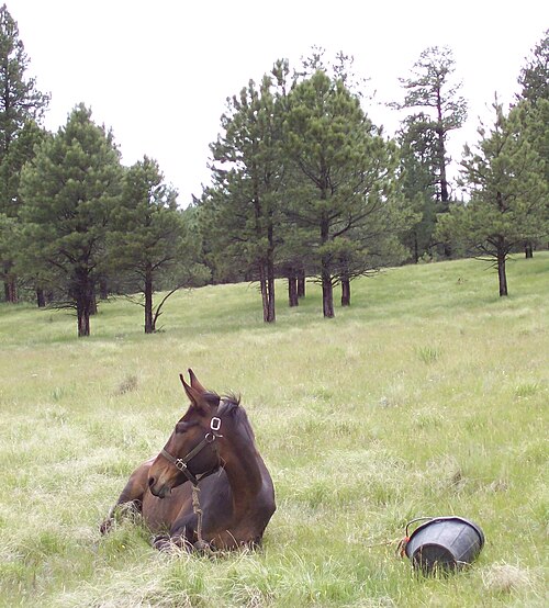
A number of recreational and/or historical uses take place in Valles Caldera. Many of these uses involve trails. Over two dozen official hiking and biking trails of varying length are available. Maps and trail descriptions may be found in "Hiking Trails in Valles Caldera National Preserve," by Coco Rae. Valles Caldera has many miles of ranch roads, livestock and game trails. These include a network of trails currently designated for horse riding.[37][38] Historically, Valles Caldera was a location for equestrian endurance races. After establishment of VCNP, the first race in the caldera was held in 2009. The largest grass valley, Valle Grande, is a venue for ski orienteering. Activities are open to the public, though some require reservations. Customer service and concierge services are provided by the Public Lands Interpretive Association. The valley floor is above 8,000 ft (2,400 m) altitude.[39]
Wildlife and livestock
Throughout the caldera, the grass valleys appear groomed: there are few saplings and mature trees lack lower branches. This is due to heavy browsing by elk and cattle and because of frequent grass fires of human and natural origin which kill the lower branches on the Engelmann spruce, Douglas-fir and Ponderosa pine that populate the uplands around the lower-elevation Montane grasslands dominating the bottoms of the calderas. The grasslands were native perennial bunch grass maintained by frequent fire before sheep and cattle grazing. Although the grass appears abundant, it is a limited resource and its growing season is short. Through the VCNP's limited grazing program, it feeds hundreds of cattle in the summer and thousands more of elk in the warm seasons, in drought winters, and during most of the year. The nutritional value of the bunch grasses is considered low or poor quality. Other wildlife that inhabits the area are Golden Eagles, striped Badgers, and the Gunnison Prairie Dog, to name a few.[40] The National Park Service states that elk population in Valles Caldera is the second largest herd in New Mexico. Hunting is permitted within the National Preserve under certain restrictions and times of the year.[41][42]
In popular culture

Valles Caldera has provided several filming locations,[43] most for films in the Western genre. Some of these locations include exterior sets, such as the weathered "ranch house" that can be seen from the highway in Valle Grande, and a small "town".
- 1971 Shoot Out
- 1977 Peter Lundy and the Medicine Hat Stallion (TV)
- 1982 The Gambler (TV)
- 1994 Troublemakers
- 1995 Buffalo Girls (TV)
- 1997 Last Stand at Saber River (TV)
- 2003 The Missing
- 2007 Seraphim Falls[44]
- 2010 Kites (film) (Hindi/Indian Film)
- 2013 The Lone Ranger
- 2012–2017 Longmire (TV series)[45]
See also
References
- 1234"Valles Caldera". Global Volcanism Program. Smithsonian Institution. Retrieved June 28, 2021.
- 1234Nasholds, Morgan W. M.; Zimmerer, Matthew J. (November 1, 2022). "High-precision 40Ar/39Ar geochronology and volumetric investigation of volcanism and resurgence following eruption of the Tshirege Member, Bandelier Tuff, at the Valles caldera". Journal of Volcanology and Geothermal Research. 431 107624. Bibcode:2022JVGR..43107624N. doi:10.1016/j.jvolgeores.2022.107624. ISSN 0377-0273. S2CID 251076136.
- ↑"Valles Caldera National Preserve". Geographic Names Information System. United States Geological Survey, United States Department of the Interior. Retrieved December 22, 2014.
- ↑"NPS Annual Recreation Visits Report". National Park Service. Retrieved March 22, 2026.
- 123Environmental News Network Staff (2000-07-17). CNN.com "New Mexico's Baca Ranch soon to be public land"Archived October 20, 2006, at the Wayback Machine. CNN.com. Retrieved on 2013-04-03.
- ↑Goff, Fraser (2009). Valles Caldera: a geologic history (1. ed.). Albuquerque: University of New Mexico Press. p. 46. ISBN 978-0-8263-4590-5.
- ↑"National Natural Landmarks - National Natural Landmarks (U.S. National Park Service)". www.nps.gov. Retrieved March 25, 2019.
Year designated: 1975
- 123Anscheutz, Kurt F. and Merlan, Thomas (2007). "More than a scenic mountain landscape: Valles Caldera National Preserve land use history". U.S. Department of Agriculture Rocky Mountain Research Center, Fort Collins, CO
- ↑"Public Law 106–248 - 106th Congress"Archived 2013-02-22 at the Wayback Machine. Valles Caldera National Preserve. Retrieved on 2013-04-04.
- ↑Environmental News Network Staff (2000-07-17). "New Mexico's Baca Ranch soon to be public land". CNN.
- ↑"About VCNP". Valles Caldera National Preserve Official Website. Retrieved on 2013-04-03.
- ↑"S.3452 - Valles Caldera National Preserve Management Act". Congress.gov. September 27, 2010.
- ↑"S.564 - Valles Caldera National Preserve Management Act". Congress.gov. May 11, 2011.
- ↑"Public Law 113-291 (Section 3043)"(PDF). gpoinfo.gov. January 11, 2018. Retrieved January 11, 2018.
- ↑Clark, Carol A. (October 9, 2015). "Interior Secretary Jewell Celebrates Valles Caldera's Addition To National Park Service". Los Alamos Post.
- ↑"Fire in the Jemez Mountains". ArcGIS StoryMaps. June 28, 2022. Retrieved October 26, 2024.
- ↑Kenderes, S. M.; Befus, K. S.; Bryson, A. N.; Whittington, A. G. (October 27, 2022). "Thermal histories and emplacement dynamics of rhyolitic obsidian lavas at Valles caldera, New Mexico". Bulletin of Volcanology. 84 (11): 98. Bibcode:2022BVol...84...98K. doi:10.1007/s00445-022-01606-z. ISSN 1432-0819.
- ↑ إيزيت، جلين أ. (1981). "طبقات الرماد البركاني: سجلات النشاط البركاني السيليسي الفتاتي في العصر السينوزوي العلوي في غرب الولايات المتحدة" . مجلة البحوث الجيوفيزيائية . 86 (B11): 10200-10222 . Bibcode : 1981JGR....8610200I . doi : 10.1029/JB086iB11p10200 .
- ↑ ديثير، ديفيد ب.؛ كامبف، ستيفاني ك. (2007). جيولوجيا منطقة خيميز II . الجمعية الجيولوجية لشمال شرق المكسيك. ص 499. مؤرشف من الأصل في 17 أكتوبر 2015. تم الاطلاع عليه في 6 نوفمبر 2015 .
- ↑ سميث، روبرت ل.؛ بيلي، روي أ. (1968)، "المراجل المتجددة"، دراسات في علم البراكين ، مذكرات الجمعية الجيولوجية الأمريكية، المجلد 116، الجمعية الجيولوجية الأمريكية، الصفحات 613-662 ، doi : 10.1130/mem116-p613
- ^ جاردنر ، جيمي ن. جوف، فريزر. جارسيا، سامي؛ هاجان، رولاند سي. (1986). “العلاقات الطبقية والاختلافات الصخرية في حقل جيميز البركاني، نيو مكسيكو”. مجلة البحوث الجيوفيزيائية . 91 (B2): 1763. بيب كود : 1986JGR....91.1763G . دوى : 10.1029/jb091ib02p01763 . ردمك 0148-0227 .
- ↑ دويل، ريتشارد ر.؛ دالريمبل، جي. برنت؛ سميث، روبرت ل.؛ بيلي، روي أ. (1968)، "المغناطيسية القديمة، وأعمار البوتاسيوم-الأرجون، وجيولوجيا الريوليت والصخور المصاحبة لها في كالديرا فالييس، نيو مكسيكو"، دراسات في علم البراكين ، مذكرات الجمعية الجيولوجية الأمريكية، المجلد 116، الجمعية الجيولوجية الأمريكية، الصفحات 211-248 ، doi : 10.1130/mem116-p211
- ↑ سيلف، س.؛ كيرشر، د.إ.؛ وولف، ج.أ. (1988). "سلسلة إل كاخيتي، كالديرا فالي، نيو مكسيكو". مجلة البحوث الجيوفيزيائية . 93 (ب6): 6113. رمز Bibcode : 1988JGR....93.6113S . doi : 10.1029/jb093ib06p06113 . ISSN 0148-0227 .
- ↑Steck, Lee K.; Thurber, Clifford H.; Fehler, Michael C.; Lutter, William J.; Roberts, Peter M.; Baldridge, W. Scott; Stafford, Darrik G.; Sessions, Robert (October 10, 1998). "Crust and upper mantlePwave velocity structure beneath Valles Caldera, New Mexico: Results from the Jemez teleseismic tomography experiment". Journal of Geophysical Research: Solid Earth. 103 (B10): 24301–24320. Bibcode:1998JGR...10324301S. doi:10.1029/98jb00750. ISSN 0148-0227.
- ↑Self, Stephen; Goff, Fraser; Gardner, Jamie N.; Wright, John V.; Kite, William M. (1986). "Explosive rhyolitic volcanism in the Jemez Mountains: Vent locations, caldera development and relation to regional structure". Journal of Geophysical Research. 91 (B2): 1779. Bibcode:1986JGR....91.1779S. doi:10.1029/jb091ib02p01779. ISSN 0148-0227.
- ↑Appendix E. Geology Field Exercises: Early Training Field Training Schedule for the first 3 Groups of Astronauts(29) Phase 1 of Geology Training - NASAhttps://www.nasa.gov/wp-content/uploads/static/history/alsj//ap-geotrips.pdf
- ↑"Los Alamos 13 W, New Mexico 1991–2020 Monthly Normals". Retrieved November 11, 2023.
- 12"xmACIS". National Oceanic and Atmospheric Administration. Retrieved November 11, 2023.
- ↑"Wolf Canyon, New Mexico 1991–2020 Monthly Normals". National Oceanic and Atmospheric Administration. Retrieved September 24, 2023.
- ↑"Hidden Valley (VC) New Mexico". Western Regional Climate Center. Retrieved January 18, 2023.
- ↑Goff, Fraser (2002-12). "Geothermal Potential of Valles Caldera, New Mexico". Geo-Heat Center, Oregon Institute of Technology. Retrieved on 2013-04-03.
- 12Brown, Donald W.; Duchane, David V.; Heiken, Grant; Hriscu, Vivi Thomas (2012), "The Enormous Potential for Hot Dry Rock Geothermal Energy", Mining the Earth's Heat: Hot Dry Rock Geothermal Energy, Springer Berlin Heidelberg, pp. 17–40, doi:10.1007/978-3-540-68910-2_2, ISBN 978-3-540-67316-3
- 123Goff, Fraser; Janik, Cathy J. (2002). "Gas geochemistry of the Valles caldera region, New Mexico and comparisons with gases at Yellowstone, Long Valley and other geothermal systems". Journal of Volcanology and Geothermal Research. 116 (3–4): 299–323. Bibcode:2002JVGR..116..299G. doi:10.1016/s0377-0273(02)00222-6. ISSN 0377-0273.
- ↑Information., Lawrence Berkeley National Laboratory. United States. Department of Energy. Office of Scientific and Technical (1982). A GEOLOGICAL AND GEOPHYSICAL STUDY OF THE BACA GEOTHERMAL FIELD, VALLES CALDERA, NEW MEXICO. Lawrence Berkeley National Laboratory. OCLC 727182004.
- ↑KERR, R. A. (November 12, 1982). "Extracting Geothermal Energy Can Be Hard". Science. 218 (4573): 668–669. Bibcode:1982Sci...218..668K. doi:10.1126/science.218.4573.668. ISSN 0036-8075. PMID 17791580.
- ↑Information., Los Alamos National Laboratory. United States. Department of Energy. United States. Department of Energy. Geothermal Division. United States. Department of Energy. Office of Scientific and Technical (1993). Continental Scientific Drilling Program: Valles Caldera, New Mexico. United States. Dept. of Energy. OCLC 727333478.
- ↑"Valles Caldera National Preserve (2004) Stewardship Register: Interim Equestrian Program"(PDF). Valles Caldera National Preserve. 2004. Archived from the original(PDF) on December 19, 2008. Retrieved June 28, 2008.
- ↑"Trail Riding Overview". Valles Caldera National Preserve. Archived from the original on May 15, 2008. Retrieved June 28, 2008.
- ↑"Hiking - Valles Caldera National Preserve (U.S. National Park Service)". www.nps.gov. Archived from the original on March 20, 2021.
- ↑"Valles Caldera National Preserve". National Park Foundation. December 5, 2023. Retrieved October 26, 2024.
- ↑ "الصيد" . محمية فاليس كالديرا الوطنية، دائرة المتنزهات الوطنية الأمريكية . تم الاطلاع عليه في 13 مارس 2026 .
- ↑ ميزا، فالينتي. "المباراة الكبيرة" . NMDGF . تم الاسترجاع في 26 أكتوبر 2024 .
- ↑ مارتن، كريج (2003). فالي غراندي: تاريخ موقع باكا رقم 1 ، دار نشر أول سيزون.
- ↑ هيفنر، تريسي (2006) شاهدنا على الشاشة الفضية (مرة أخرى!) ، لا فينتانا إن لوس فاليس، المجلد 1، العدد 2، الصفحة 3.
- ↑ رعاة البقر، رجال العصابات، والأطباء الخاصون؛ مجلة ماركي؛ 27 أكتوبر 2012.
للمزيد من القراءة
- فريزر جوف، فالس كالديرا: تاريخ جيولوجي . 2009، مطبعة جامعة نيو مكسيكو. ISBN 978-0-8263-4590-5مراجعة مؤرشفة بتاريخ 7 أبريل 2012، في موقع Wayback Machine في مجلة نيو مكسيكو : "بغض النظر عن اهتمامك بـ Valles Caldera، ستتعلم شيئًا جديدًا في كتاب فريزر جوف الجديد."
- كوكو راي، "مسارات المشي في محمية فالي كالديرا الوطنية" . 2020. الدليل الكامل للمسارات في محمية فالي كالديرا الوطنية.
روابط خارجية
- محمية فالي كالديرا الوطنية ، الموقع الرسمي
- موقع معهد الفيزياء في فالي كالديرا بالبرازيل (باللغة الإنجليزية)
- دليل السفر الجيولوجي من المعهد الجيولوجي الأمريكي
- منظمة كالدرا أكشن ، وهي منظمة مناصرة
 دليل السفر إلى محمية فالي كالديرا الوطنية من ويكي فويج
- براكين VEI-7
- البراكين المتصدعة
- جبال جيميز
- براكين نيو مكسيكو
- فوهات بركانية في نيو مكسيكو
- البراكين المعقدة
- فوهات بركانية من العصر البليستوسيني
- المعالم الطبيعية الوطنية في نيو مكسيكو
- غابة سانتا فيه الوطنية
- تضاريس مقاطعة ريو أريبا، نيو مكسيكو
- تضاريس مقاطعة ساندوفال، نيو مكسيكو
- نيو مكسيكو الرباعية