
High Five Interchange
The High Five Interchange is one of the first five-level stack interchanges built in Dallas, Texas. Located at the junction of the Lyndon B. Johnson Freeway (Interstate 635, or I-635) and the Central Expressway (U.S. Highway 75, or US 75), it replaces an antiquated combination interchange constructed in the 1960s.
The $261 million (equivalent to $434 million in 2024[2]) project was started in 2002 and completed in December 2005; 13 months ahead of schedule.[3] It was designed by HNTB and built by Zachry Construction Corporation.
The interchange is considered by Popular Mechanics to be one of "The World's 18 Strangest Roadways" because of its height (as high as a 12-story building), its 43 permanent bridges, and other unusual design and construction features.[4] In 2006, the American Public Works Association (APWA) named the High Five Interchange as "Public Works Project of the Year".[5]
Description
The High Five Interchange, north of downtown in Dallas, Texas, is a massive five-level freewayinterchange. It is the junction of two major highways carrying heavy rush-hour traffic, the Lyndon B. Johnson Freeway (I-635) and the Central Expressway (US 75), and is the first five-level stack interchange to be built in the city.[5]
It replaces the antiquated three-level modified cloverleaf interchange built in the 1960s, which caused a severe bottleneck by narrowing US 75 down to two lanes at the junction of the two highways. The looped ramps of the cloverleaf forced motorists to slow down drastically, backing up traffic. Left-hand exits contributed to the congestion. Further, its two frontage roads were not directly connected to each other, making local access difficult.[6]
Alluding to the celebratory gesture, the "High Five" name refers to the five flyover ramps that tower over the landscape, handling the left-turn movements.[7] The interchange is as high as a 12-story building[3] and includes 43 bridges spread across five levels (the "High Five"), 710 support tiers, and 60 miles (97 km) of additional highway lanes. The highest ramps are 100 feet (30 m) above ground.[8] The lanes of US 75, which are on the bottom level, are 20 feet (6.1 m) below ground level, giving the structure a total height of 117 feet (36 m) from bottom to top.[9] As part of the project, I-635 was widened to include four dedicated high-occupancy vehicle lanes (HOV lanes) that are barrier-separated and reversible.[10][11]
The new lanes for regular traffic were built on the outer vacant right-of-way, while the HOV lanes were built in the median. The original I-635 lanes that passed through the former interchange, now demolished, were relocated between the new regular and HOV lanes.
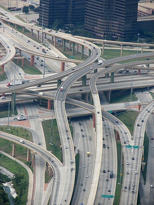
From bottom to top, the roads on the five levels are:[6][12]
- Level I: US 75, a six-lane highway, three lanes going each way
- Level II: The junction of the two six-lane frontage roads, each having three through lanes in each direction, left-turn lanes, and turnarounds, and easy access to US 75 and I-635
- Level III: I-635, 10 regular lanes, five going each way, and four HOV lanes (two going each way) separated by barriers
- Levels IV and V: Direct connection ramps (two levels), eliminating the left exits of the modified cloverleaf
يُزيّن التقاطع بنقوش محفورة على عناصر خرسانية مسبقة الصب ، بالإضافة إلى ألوان محددة من قِبل إدارة النقل في تكساس (TxDOT). [ 13 ] كما يضم تقاطع هاي فايف مسارًا للمشي وركوب الدراجات، يُسمى مسار كوتونوود، ويمتد أسفل جميع مستويات التقاطع. وقد شُيّد الجزء من المسار الذي يمر أسفل التقاطع كجزء من مشروع تقاطع هاي فايف من قِبل إدارة النقل في تكساس (TxDOT). [ 14 ]
تاريخ
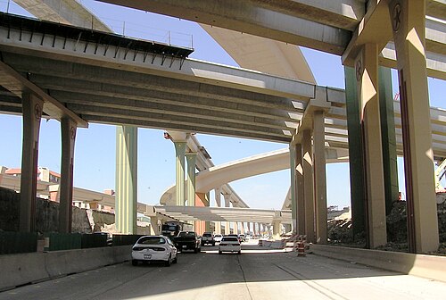
تم التخطيط لمشروع تقاطع هاي فايف كبديل للتقاطع القديم القائم، الذي كان يستوعب 500 ألف مركبة يوميًا ويقع في إحدى أكثر المناطق التجارية كثافةً في دالاس. وقد كان مشروعًا تعاونيًا بين إدارة النقل في تكساس (TxDOT) وسائقي السيارات المتضررين وأصحاب العقارات، والمقاول الرئيسي، شركة زكري للإنشاءات. وكان من الاعتبارات الأساسية إنجاز المشروع بأقل قدر ممكن من تعطيل حركة المرور . [ 15 ]
من بين الأسباب التي دفعت إلى تطوير التقاطع، بالإضافة إلى الحاجة إلى زيادة تدفق حركة المرور وتقليل الازدحام، تحسين جودة الهواء والسلامة وسهولة الوصول المحلي. [ 13 ]
Zachry Construction Corporation submitted the lowest bid and was awarded the $261 million (equivalent to $434 million in 2024[2]) contract by TxDOT, the largest ever by that agency. The construction contract for the interchange was unique in that it contained elements not found in other construction project contracts.[7] For example, it specified the concrete maturity method to be used to ensure the concrete's strength (the first time TxDOT had ever done so) and contained an early-completion bonus, a sliding scale of up to $11 million (equivalent to $18.3 million in 2024)[2] if the company completed the contract within four years.[16] Also built into the construction contract was a provision that Zachry be charged for "lane rentals" by TxDOT for time they closed down a traffic lane, with fees based on hourly assessments and the time of day the lane was closed. The fees ranged from $50 to a high of $110,000 for rush hours (equivalent to $83 to $180,000 in 2024[2]).[7] In order not to interfere with traffic flow during construction, the new interchange was designed largely as elevated flyover ramps and viaducts so they could be built high over the existing junction lanes; once traffic was transferred to the new structures, the old lanes could simply be closed off and removed. Little of the original interchange remained when the project was finished.[13]
To save time and money, innovative construction methods were employed. The original plans called for the segments of the long ramps and spans (used to direct-connect roads) to be made of steel, but, because building with steel would interfere with heavy traffic flow during construction, cast-in-place segmental concrete was substituted in the plans. Zachry decided, however, to use precast concretesegmental bridges, rather than casting the bridge elements in place, and used a unique machine, designed and constructed by Deal S.R.L. of Italy and costing about $1 million (equivalent to $1.66 million in 2024[2]), to move the pieces into place.[7][9]
خلال أعمال الإنشاء، استُخدم 2.2 مليون ياردة مكعبة (1.7 × 10 ^ 6 متر مكعب ) من أعمال الحفر ، وخُلط 350,000 ياردة مكعبة (270,000 متر مكعب ) من الخرسانة في الموقع، وبُنيت 300,000 قدم مكعب (8,500 متر مكعب ) من الجدران الاستنادية . إضافةً إلى ذلك، أُنجزت 40,000 قدم (12,000 متر) من الآبار المحفورة و 75,000 قدم طولي (23,000 متر) من أنابيب الصرف . وإلى جانب بناء 43 جسراً دائماً، بُنيت ستة جسور مؤقتة، مما نتج عنه 2.3 مليون قدم مكعب (0.065 × 10 ^ 6 متر مكعب ) من سطح الجسر . [ 6 ]
صممت شركة HNTB المشروع ، [ 5 ] وقدمت استشارات هندسية احترافية طوال فترة الإنشاء، [ 16 ] التي بدأت في عام 2002 واكتملت في ديسمبر 2005، أي قبل أكثر من 13 شهرًا من الموعد المخطط له. [ 3 ]
تعرُّف
في عام 2006، منحت جمعية الأشغال العامة الأمريكية (APWA) مشروع "هاي فايف" جائزة "مشروع الأشغال العامة للعام" نظراً لضخامته، وتصميمه المبتكر، وتعقيده، وسرعة تنفيذه، والحاجة المُلحة التي لبّاها للمجتمع. وقد نالت وزارة النقل في تكساس (TxDOT) بصفتها الجهة المُديرة، وشركة زكري للإنشاءات بصفتها المقاول الرئيسي، وشركة HNTB بصفتها الاستشاري الرئيسي، الجائزة تقديراً لتعاونهم المثمر في إنجاز المشروع. [ 5 ]
صنّفت مجلة Popular Mechanics هذا التقاطع ضمن قائمة "أغرب 18 طريقاً في العالم"، واصفةً إياه بأنه "متاهة من المسارات" و"تحفة هندسية من خمسة مستويات" نظراً لارتفاعه، وعدد جسوره، وغيرها من خصائص التصميم والبناء غير المألوفة. [ 4 ]
انظر أيضاً
 بوابة تكساس
 بوابة الطرق الأمريكية
مراجع
- ↑ ديكسون، جوردون (23 ديسمبر 2016). "ممر هاي فايف يحطم الرقم القياسي للارتفاع" . صحيفة فورت وورث ستار-تليجرام . تم الاطلاع عليه في 3 سبتمبر 2025 .
- 1 2 3 4 5 جونستون، لويس؛ ويليامسون، صموئيل هـ. (2023). "ما هو الناتج المحلي الإجمالي للولايات المتحدة آنذاك؟" . قياس القيمة . تم الاسترجاع في 30 نوفمبر 2023 . United States Gross Domestic Product deflator figures follow the MeasuringWorth series.
- 123"TxDOT History: 2005 to 2001". Texas Department of Transportation. Archived from the original on February 20, 2012. Retrieved January 2, 2012.
- 12Sweeney, Chris (December 17, 2009). "The World's 18 Strangest Roadways: Gallery". Popular Mechanics. ISSN 0032-4558. Archived from the original on February 9, 2015. Retrieved January 2, 2012.
- 1234Wickstrom, Becky (June 6, 2006). "Dallas High Five Interchange honored as Public Works Project of the Year"(PDF) (Press release). American Public Works Association. Archived(PDF) from the original on February 22, 2012. Retrieved January 5, 2012.
- 123"Best of 2006 Awards: Dallas High Five Interchange, Dallas"(PDF). Texas Construction. December 2006. Archived from the original(PDF) on April 25, 2012. Retrieved January 3, 2012.
- 1234Recht, David (April 17, 2006). "Dallas Highway Gets a High Five". Construction Equipment Guide. Archived from the original on May 11, 2012. Retrieved January 3, 2012.
- ↑"High Five Interchange, Dallas - Texas"(PDF). Chryso. Archived from the original(PDF) on April 26, 2012. Retrieved January 2, 2012.
- 12Knutson, Kraig; Schexnayder, Clifford J.; Fiori, Christine M.; Mayo, Richard (2009). "Dallas High Five Project". Construction Management Fundamentals (2nd ed.). McGraw Hill Education. ISBN 978-0-07-340104-1. Archived from the original on May 13, 2012. Retrieved January 3, 2012.
- ↑ "أول تقاطع من خمسة مستويات في دالاس" (ملف PDF) . وزارة النقل في تكساس . يوليو 2001. مؤرشف (ملف PDF) من الأصل في 24 فبراير 2024. تم الاطلاع عليه في 2 يناير 2012 .
- ↑ سكورونيك، دوغلاس أ.؛ رانفت، ستيفن إي.؛ كوثورن، أ. سكوت. تقييم ممرات المركبات عالية الإشغال في منطقة دالاس (ملف PDF) (تقرير). معهد تكساس للنقل . مؤرشف (ملف PDF) من الأصل في 22 أكتوبر 2020. تم الاطلاع عليه في 2 يناير 2012 .
- ↑ ويلسون، بيل (19 يونيو 2002). "نجمة تكساس الخماسية" . الطرق والجسور . الرقم الدولي الموحد للدوريات 8750-9229 . مؤرشف من الأصل في 24 فبراير 2024. تم الاطلاع عليه في 4 يناير 2012 .
- 1 2 3 سكينز، ويسلي (شتاء 2004). "تحية: تقاطع رئيسي على طريق سريع في دالاس يتميز بطابع تكساسي أصيل من حيث الحجم والجمال" (ملف PDF) . حلول الطلاء . شيروين ويليامز . الصفحات 10-12 . مؤرشف من النسخة الأصلية (ملف PDF) بتاريخ 19 نوفمبر 2011. تم الاطلاع عليه بتاريخ 2 يناير 2012 .
- ↑ "مسار كوتونوود" (ملف PDF) . إدارة الحدائق والترفيه بمدينة دالاس. مؤرشف من النسخة الأصلية (ملف PDF) بتاريخ 27 أكتوبر 2010. تم الاطلاع عليه بتاريخ 23 فبراير 2010 .
- ↑ "التحكم المحلي - قصص نجاح" . وزارة النقل في تكساس . مؤرشف من الأصل في 15 أبريل 2012. تم الاطلاع عليه في 2 يناير 2012 .
- دراسة حالة: مشروع تقاطع دالاس هاي-فايف؛ دالاس، تكساس ( ملف PDF) (تقرير). إنجيوس. مؤرشف من الأصل (ملف PDF) بتاريخ 5 مارس 2016. تم الاطلاع عليه بتاريخ 3 يناير 2012 .
روابط خارجية

- الطرق السريعة في ولاية تكساس
- الطرق السريعة في دالاس
- التقاطعات الطرقية في الولايات المتحدة
- الطريق السريع الأمريكي رقم 75