
سارانجاني
سارانجاني ، رسميًا مقاطعة سارانجاني ( بالسيبيونو : Lalawigan sa Sarangani ؛ هيليجينون : Kapuoran sang Sarangani ؛ ماجويندانون : Dairat nu Sarangani ، جاوي : دايرت نو سرڠان؛ بالفلبينية : Lalawigan ng Sarangani )، هي مقاطعة في الفلبين تقع في منطقة سوكسسكسارجن . عاصمتها ألابيل بينما جلان هي البلدية الأكثر اكتظاظا بالسكان في المحافظة. مع خط ساحلي يبلغ طوله 230 كيلومترًا (140 ميلًا) على طول خليج سارانجاني وبحر سيليبس ، تقع المقاطعة في أقصى الطرف الجنوبي من جزيرة مينداناو ، وتحدها جنوب كوتاباتو ودافاو ديل سور من الشمال، ودافاو أوكسيدنتال من الشرق، وبحر سيليبس من الجنوب.
سارانجاني هي جزء من مجموعة تطوير جنوب كوتاباتو-كوتاباتو-سلطان كودارات-سارانجاني-جنرال سانتوس (سوكسكسارجين)، وترتبط بطرق معبدة بالمطار الدولي وميناء جنرال سانتوس .
تنقسم المقاطعة إلى قسمين، يفصل بينهما خليج سارانجاني ومدينة جنرال سانتوس، وكانت في السابق جزءًا من جنوب كوتاباتو حتى أصبحت مقاطعة مستقلة في عام 1992. [ 3 ]
منطقة جنرال سانتوس الحضرية أو مترو جنرال سانتوس هي منطقة حضرية تضم مدينة جنرال سانتوس شديدة التحضر والمركز الإقليمي للصناعات الزراعية في ألابيل وبلدات جلان وكيامبا وماسين ومايتوم ومالاباتان ومالونجون والمقاطعات المجاورة في جنوب كوتاباتو ، بالإضافة إلى مترو جنرال سانتوس وإضافة بحيرة سيبو وبولومولوك وتبولي وتوبي .
تاريخ
التاريخ المبكر
تُعدّ مايتوم، في مقاطعة سارانجاني ، أقدم حضارة في المقاطعة، حيث عُثر على أواني مايتوم الفخارية ذات الشكل البشري، أو ما يُعرف بأواني مايتوم. ويُرجّح أن تاريخ هذه الأواني يعود إلى الفترة ما بين 5 قبل الميلاد و370 ميلادي، ما يجعلها من أقدم الأواني في منطقة جنوب شرق آسيا والفلبين. ويشهد هذا الاكتشاف على تاريخ طويل من التبادل الثقافي بين سكان سارانجاني.
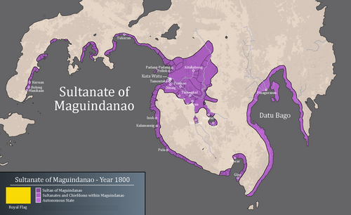
The Sarangani was once part of Sultanate of Maguindanao. The establishment of the Sultanate in the area caused more Maguindanaon settlers arrival. After the fall of the Sultanate of Maguindanao as a great power in Mindanao, Datu Uto of Buayan expanded his domain towards Sarangani Bay. Sarangani would eventually be under the Sultanate of Buayan until the American era.
Spanish colonial era
Sarangani Island (now part of Davao Occidental) was named Antonia by the SpanishexplorerRuy López de Villalobos in 1543, in honor of Antonio de Mendoza y Pacheco, the viceroy of New Spain who had appointed López de Villalobos to lead an expedition to the Western Islands (now the Philippines) because of their relation by marriage. The early inhabitants who first inhabited Sarangani were the indigenous natives, called MunaTo, a native term for "first people."[4]
Japanese occupation
In 1942, the Japanese troops occupied Southern Cotabato. In 1945, Filipino troops of the 6th, 10th, 101st and 102nd Infantry Division of the Philippine Commonwealth Army and 10th Constabulary Regiment of the Philippine Constabulary entered in and liberated Southern Cotabato and fought against the Japanese Imperial Army forces during the Battle of Cotabato at the end of World War II under the Japanese Occupation.
Philippine independence
Before its inception in 1992, Sarangani was part of South Cotabato under its third district. The province was created by Republic Act No. 7228 on March 16, 1992,[3] penned by Congressman James Chiongbian, who would later become the province's first representative to the House of Representatives, ratified in a plebiscite on May 19, 1992 and installed its first set of officials on November 28, 1992. His wife, Priscilla Chiongbian, became the first Governor of Sarangani.
The Sangil people are active in the struggle for self-determination as part of their strategy to preserve and develop their culture and social institutions. The creation of Sarangani province itself was an effort to ease tensions between the Sangil people and the Philippine government.[5]
Geography

Sarangani covers a total area of 3,601.25 square kilometers (1,390.45 sq mi)[6] occupying the southern tip of the Soccsksargen in central Mindanao. The province is bordered on the central-north by South Cotabato, northeast by Davao del Sur, east by Davao Occidental, south by the Sarangani Bay and Celebes Sea, and northwest by Sultan Kudarat.
Sarangani is divided into two (eastern and western) sections, separated by the Sarangani Bay and General Santos in the middle. The western portion comprises the towns of Maitum, Kiamba, and Maasim, and is bounded on the north by South Cotabato and on the northwest by Sultan Kudarat. The eastern section consists of Alabel, Glan, Malapatan, and Malungon.
Administrative divisions
Sarangani comprises seven municipalities. A single legislative district encompasses all towns.[6]

| Municipality[i] | Population | ±% p.a. | Area[6] | Density(2020) | Barangay | |||||||
|---|---|---|---|---|---|---|---|---|---|---|---|---|
| (2020)[2] | (2015)[7] | km2 | sqmi | /km2 | /sqmi | |||||||
| 6°06′10″N125°17′31″E / 6.1027°N 125.2920°E / 6.1027; 125.2920 (Alabel) | Alabel | † | 15.8% | 88,294 | 80,359 | +1.81% | 510.98 | 197.29 | 170 | 440 | 13 | |
| 5°49′21″N125°12′17″E / 5.8225°N 125.2046°E / 5.8225; 125.2046 (Glan) | Glan | 19.6% | 109,547 | 118,263 | −1.45% | 610.30 | 235.64 | 180 | 470 | 31 | ||
| 5°59′19″N124°37′27″E / 5.9885°N 124.6241°E / 5.9885; 124.6241 (Kiamba) | Kiamba | 11.8% | 65,774 | 61,058 | +1.43% | 328.68 | 126.90 | 200 | 520 | 19 | ||
| 5°51′40″N124°59′48″E / 5.8610°N 124.9967°E / 5.8610; 124.9967 (Maasim) | Maasim | 11.6% | 64,940 | 59,468 | +1.69% | 500.43 | 193.22 | 130 | 340 | 16 | ||
| 6°03′41″N124°29′45″E / 6.0613°N 124.4957°E / 6.0613; 124.4957 (Maitum) | Maitum | 7.9% | 44,185 | 44,595 | −0.18% | 290.66 | 112.22 | 150 | 390 | 19 | ||
| 5°58′15″N125°17′18″E / 5.9707°N 125.2882°E / 5.9707; 125.2882 (Malapatan) | Malapatan | 14.4% | 80,741 | 76,914 | +0.93% | 609.28 | 235.24 | 130 | 340 | 12 | ||
| 6°22′31″N125°16′18″E / 6.3752°N 125.2717°E / 6.3752; 125.2717 (Malungon) | Malungon | 18.9% | 105,465 | 103,604 | +0.34% | 750.92 | 289.93 | 140 | 360 | 31 | ||
| Total | 558,946 | 544,261 | +0.51% | 3,601.25 | 1,390.45 | 160 | 410 | 141 | ||||
| † Provincial capital | Municipality | |||||||||||
| ||||||||||||

Demographics
| Year | Pop. | ±% p.a. |
|---|---|---|
| 1918 | 19,043 | — |
| 1939 | 24,051 | +1.12% |
| 1948 | 36,166 | +4.64% |
| 1960 | 73,162 | +6.05% |
| 1970 | 127,637 | +5.72% |
| 1975 | 166,179 | +5.43% |
| 1980 | 219,372 | +5.71% |
| 1990 | 283,141 | +2.59% |
| 1995 | 367,006 | +4.98% |
| 2000 | 410,622 | +2.44% |
| 2007 | 475,514 | +2.04% |
| 2010 | 498,904 | +1.76% |
| 2015 | 544,261 | +1.67% |
| 2020 | 558,946 | +0.56% |
| 2024 | 580,915 | +0.93% |
| Source: Philippine Statistics Authority[7][8][9] | ||
The population of Sarangani in the 2024 census was 580,915 people,[2] with a density of 160 inhabitants per square kilometer or 410 inhabitants per square mile.
Religion
Christianity is the majority religion in the province with a total of 79% (48% Roman Catholicism[10] and 31% evangelicals).[11] Other religious minorities are Islam (9%)[12] and Iglesia ni Cristo (2%).[13] The remainder is usually divided among other Christian churches. The majority of Muslims are from the Sangil, Maguindanao, and Kalagan ethnic groups. Furthermore, there are quite a few individuals who have converted to Islam, also known as Balik Islam (reverting to Islam).[5]
Ethnic groups
Sarangani has a huge ethnic diversity, such as Lumads, consisting of Blaan, T'boli, Tagakaulo, Kalagan, Manobo, Ubo, Moro Muslims, and Christian settlers, mainly from Cebu, Bohol, Siquijor, Negros and Panay in Visayas and Ilocandia and Cagayan Valley in Luzon Muslims comprise 7 ethnic groups, Lumads 17 ethnic groups, and Christian migrant settlers, at least 20 ethnic groups.[14]Sarangani and Sangil peoples, although no longer dominant, still have a presence here.[5] Being one of the most ethnically and linguistically diverse regions in Mindanao.[14]
The Blaan people are the largest minority and are spread across the municipalities of Malapatan, Glan, Alabel, Maasim, and Malungon. Most of Blaan people lives in Malapatan, constituting 37% of the municipality's population. Other ethnic groups, such as the Maguindanao people reside in the municipalities of Malapatan, Maitum, and Maasim, the T'boli people mostly reside in Maitum, Kiamba, and Maasim, while the Tagakaulo people is almost entirely in Malungon. Cebuano settlers are found in Glan and Alabel, Ilonggo (Hiligaynon) are located in Malungon, while Ilocano mostly live in Kiamba and Maitum.[14]
Thus, the mixed population of Sarangani is quite diverse, with the language of the Christian settlers being used commonly by both Moro Muslims and natives, consisting of the Blaan and Cebuano-speaking Muslims on the east coast, the Tboli, Manobo, and Ilocano-speaking Muslims on the west coast, and the Ilonggo-speaking Blaan and Tagakaulo peoples of the northern highlands.[14]
Economy
Coconut, corn, rice, banana, mango, durian, rubber, and sugarcane are major crops now being planted by the inhabitants. The province has plantations (mango, banana, pineapple, asparagus), cattle ranches, and commercial fishponds that have been operating in the area, some of which having existed as far back as 40 years.
Electricity comes from the National Power Corporation, and augmented by a 50 MW power plant in Alabel, the province's capital. Water is provided for by sustainable spring development projects.
Government

Elected Officials (2025-2028)
Elected Officials (2022-2025)
Elected Officials (2019-2022)
Elected Officials (2016-2022)
Elected Officials (2013-2016)
Elected Officials (2010-2013)
Elected Officials (2007-2010)
Elected Officials (2004-2007)
Elected Officials (2001-2004)
Elected Officials (1998-2001)
Elected Officials (1995-1998)
Elected Officials (1992-1995)
Note
|
Tourism
Sarangani celebrates its foundation anniversary every November, named as MunaTo Festival.[23]
Sarangani has ancient burial jars, discovered by archaeologists from the National Museum in Ayub Cave in Maitum, in 1991 and in 2008, and at Sagel Cave in Maitum (now declared by National Historical Institute as a national historical site). Amid Mindanao's armed conflicts, artifacts found thereat prove settlements of pre-historic civilization in Maitum.[23][24]
Notable people
- Manny Pacquiao - boxer and former senator having his family from Sarangani.
- Jinkee Pacquiao - wife of Manny Pacquiao and former Sarangani vice governor (2013). Her family is from Sarangani.
References
- ↑"List of Provinces". PSGC Interactive. Makati, Philippines: National Statistical Coordination Board. Retrieved May 13, 2014.
- 123Census of Population (2020). "Region XII (Soccsksargen)". Total Population by Province, City, Municipality and Barangay. Philippine Statistics Authority. Retrieved July 8, 2021.
- 12"An Act Creating the Province of Sarangani"(PDF). House of Representatives of the Philippines. March 16, 1992. Archived from the original(PDF) on February 7, 2016. Retrieved January 8, 2016.
- ↑balita.ph/2008, Man-made island resort now a Sarangani landmark
- 123Bara, Hannbal. "The History of the Muslim in the Philippines". ncca.gov.ph. National Commission for Culture and the Arts. Retrieved August 7, 2025.
- 123"Province: Sarangani". PSGC Interactive. Quezon City, Philippines: Philippine Statistics Authority. Retrieved January 8, 2016.
- 12Census of Population (2015). "Region XII (Soccsksargen)". Total Population by Province, City, Municipality and Barangay. Philippine Statistics Authority. Retrieved June 20, 2016.
- ↑Census of Population and Housing (2010). "Region XII (Soccsksargen)"(PDF). Total Population by Province, City, Municipality and Barangay. National Statistics Office. Retrieved June 29, 2016.
- ↑Censuses of Population (1903–2007). "Region XII (Soccsksargen)". Table 1. Population Enumerated in Various Censuses by Province/Highly Urbanized City: 1903 to 2007. National Statistics Office.
- 12"MAP: Catholicism in the Philippines". January 18, 2015.
- 12"Philippine Church National Summary". Archived from the original on October 26, 2019. Retrieved October 8, 2017.
- 12"MAP: Islam in the Philippines". July 17, 2015.
- 12"MAP: Iglesia ni Cristo in the Philippines". July 26, 2014.
- 1234"Sarangan People". sarangani.gov.ph. Sarangani Provincial Government. Retrieved August 8, 2025.
- ↑"Poverty incidence (PI):". Philippine Statistics Authority. Retrieved December 28, 2020.
- ↑"Estimation of Local Poverty in the Philippines"(PDF). Philippine Statistics Authority. November 29, 2005.
- ↑"2009 Official Poverty Statistics of the Philippines"(PDF). Philippine Statistics Authority. February 8, 2011.
- ↑"Annual Per Capita Poverty Threshold, Poverty Incidence and Magnitude of Poor Population, by Region and Province: 1991, 2006, 2009, 2012 and 2015". Philippine Statistics Authority. August 27, 2016.
- ↑"Annual Per Capita Poverty Threshold, Poverty Incidence and Magnitude of Poor Population, by Region and Province: 1991, 2006, 2009, 2012 and 2015". Philippine Statistics Authority. August 27, 2016.
- ↑"Annual Per Capita Poverty Threshold, Poverty Incidence and Magnitude of Poor Population, by Region and Province: 1991, 2006, 2009, 2012 and 2015". Philippine Statistics Authority. August 27, 2016.
- ↑"Updated Annual Per Capita Poverty Threshold, Poverty Incidence and Magnitude of Poor Population with Measures of Precision, by Region and Province: 2015 and 2018". Philippine Statistics Authority. June 4, 2020.
- ↑"2021 Full Year Official Poverty Statistics of the Philippines"(PDF). Philippine Statistics Authority. August 15, 2022. Retrieved April 28, 2024.
- 12"'MunaTo' festival". Manila Bulletin. November 29, 2013. Retrieved April 17, 2016.
The provincial government started their celebration of its 21st foundation anniversary on Thursday and officially opened its 11th "MunaTo Festival" starting November 27 and will run up to December 6, this year.
- ↑Pelima, Russtum G. (November 10, 2008). "Island resort now Sarangani landmark". Philippine Information Agency. PIO Sarangani/ICC GenSan. Archived from the original on February 11, 2009. Retrieved April 17, 2016.
Despite armed conflicts occurring in Mindanao, artifacts found by archaeologists from the National Museum in Ayub Cave in 1991 and Sagel Cave this year prove settlements of pre-historic civilization in Maitum.
External links
 Media related to Sarangani at Wikimedia Commons
 Geographic data related to Sarangani at OpenStreetMap
- Official Website of the Provincial Government of Sarangani
- Local Governance Performance Management System
- Sarangani
- Provinces of the Philippines
- Provinces of Soccsksargen
- States and territories established in 1992
- 1992 establishments in the Philippines
- Subnational enclaves and exclaves in the Philippines