
Yozgat
Yozgat is a city in the Central Anatolia Region of Turkey. It is the seat of Yozgat Province and Yozgat District.[2] Its population is 92,775 (2025).[1]
The city developed as the principal centre of the historic Bozok region during the Ottoman period under the patronage of the influential Çapanoğlu family, who established Yozgat as an important administrative and commercial centre in Central Anatolia. Today, the city serves as a regional hub for agriculture, education, and public administration and is known for landmarks such as the Çapanoğlu Mosque, one of the earliest examples of Ottoman Baroque architecture in Anatolia.[3]
Yozgat borders eight other provinces in central Turkey, Çorum (northwest), Amasya (north), Tokat (northeast), Sivas (east), Kayseri (southeast), Nevşehir (south), Kırşehir (southwest), and Kırıkkale (west).
Etymology
According to local folk etymology, one explanation for the name Yozgat is that it derives from “Yüz Kat” (“hundred floors”), referring to the stepped elevation of the terrain from Saray Köyü toward the city centre; however, this interpretation is considered a popular legend rather than a verified linguistic origin.[4]
History

The modern city of Yozgat originated as a small settlement known as Bozok, named after the Bozok branch of the Oghuz Turks who settled in the region during the Seljuk Empire, Sultanate of Rum, and later the Ottoman period. Ottoman sources record the city's name as Yozğad (Ottoman Turkish: یوزغاد), from which the modern form Yozgat is derived.[5] In some European maps and geographical works of the late nineteenth and early twentieth centuries, the city's name was rendered as Jozgad.[6] Among the local Greek-speaking population, the city was known as Γιωσγάτη (Giosgáti) or Γιοασγάτη (Gioasgáti).[7][8] the Greek-speaking population also referred to Yozgat as 'Bozouki'."[9] The city is known in Armenian as Եօզղաթ (Eōzġatʻ), with historical variants including Եօզկաթ (Eōzkatʻ), also rendered as Եոզղաթ (Yozghat) and Եոզղատ (Yozghad).[10][11]
Hittites c. 1600–1200 BC Phrygia c. 800–695 BC
Achaemenid Empire c. 547–333 BC
Macedonian Empire 333–323 BC Kingdom of Cappadocia c. 320–17 BC
Roman Empire 17 BC–395 AD
Byzantine Empire 395–1071
Seljuk Empire 1071–1243
Sultanate of Rum 1077–1308
Ilkhanate 1243–1335
Eretna Beylik 1335–1381
Ottoman Empire 1398–1922
Turkey 1923–present

Although the surrounding area had been inhabited since antiquity, the town itself did not emerge as a significant urban centre until the eighteenth century. Its growth was closely associated with the rise of the Çapanoğlu family, a powerful local dynasty that established Yozgat as the administrative and economic centre of the Bozok region. The construction of major public buildings, including the Çapanoğlu Mosque in 1779, contributed to the town's development. Following the establishment of the Turkish Republic, the name Bozok was officially changed to Yozgat in 1927.[12][13][14]
Antiquity

The area in and around Yozgat has been inhabited since prehistoric times and formed part of the ancient cultural landscape of Central Anatolia. During the Bronze Age, it was located within the lands of the Hatti and later became an important part of the Hittite Empire, one of the major powers of the ancient Near East. Archaeological research at sites such as Uşaklı Höyük, Alişar Höyük and Kerkenes Dağ has demonstrated that the region was a significant centre of settlement and political activity during the second millennium BC.[15]
Following the collapse of the Hittite Empire, the region came under the influence of the Phrygians, Medes and Achaemenid Persians. After the conquests of Alexander the Great in the fourth century BC, it formed part of the Hellenistic world before being incorporated into the Roman Empire. The ancient city of Tavium, located near modern Büyüknefes, became one of the principal settlements of the Galatian tribe of the Trocmi and later flourished as a Roman regional centre.[16]


Byzantine era
Under Byzantine rule, the region remained an important part of Central Anatolia and contained numerous settlements, fortifications and religious sites. Not much is known about the settlement in what is now the modern city of Yozgat during this period. Following the Battle of Manzikert in 1071, the area gradually came under Turkish control and was incorporated into the Seljuk Sultanate of Rum. The modern city of Yozgat developed much later, emerging as a settlement known as Bozok during the Ottoman period and growing rapidly under the patronage of the Çapanoğlu family in the eighteenth century.[17][18]

Ottoman era
The Ottoman Empire annexed Yozgat in 1398. At around 1911, it was the chief town of a sanjak of the same name in the Ankara Vilayet. There was a trade in yellow madder (Stil de grain yellow) and mohair. The sanjak was very fertile, and contained good breeding-grounds in which cattle, horses and even camels were reared for the local agriculture and foreign trade. Yozgat was the site of a prisoner of war camp in the First World War, holding British and Empire officers captured at the Siege of Kut,[19] including E. H. Jones and C. W. Hill, whose escape attempts were recounted in the book The Road to En-dor.[20]
Demographics
According to the Address-Based Population Registration System (ADNKS) of the Turkish Statistical Institute (TÜİK), the population of Yozgat city was 92,643 in 2022.[21] The population of the city has remained relatively stable in recent decades, with limited growth compared to major urban centres in Turkey.
Yozgat has experienced net out-migration since the late 20th century, as many residents have moved to larger cities such as Ankara, Istanbul, and Kayseri in search of employment and educational opportunities. As a result, the city’s population structure reflects a balance between urban residents and a surrounding rural population dependent on agriculture.[22]
The population is predominantly Turkish-speaking, and the city functions as the administrative centre of Yozgat Province, serving surrounding districts and rural settlements.[23]
The population of Yozgat city (Merkez) has shown gradual growth in the early twenty-first century, reflecting urban consolidation within the provincial centre.
| Year | Population |
|---|---|
| 2009 | 73,835 |
| 2013 | 79,240 |
| 2017 | 88,730 |
| 2022 | 92,643 |
Transport

Yozgat is located in Central Anatolia and is connected to other regions of Turkey primarily by road and rail. The city lies along the Ankara–Sivas highway corridor, providing road access to Ankara, Sivas, Kayseri, and surrounding provinces. Intercity bus services operate regularly between Yozgat and major Turkish cities, and the Yozgat Bus Terminal is located close to the city centre.[25]
Rail transport in the region is served by the Ankara–Kayseri railway line, which passes through Yozgat Province. Stations within the province include Yerköy, Şefaatli, and Yenifakılı. In addition, the Ankara–Sivas high-speed railway line passes through Yozgat, providing faster connections to Ankara and eastern Anatolia via nearby stations such as Yerköy and Yozgat.[26]
Air transportation in Yozgat is expected to be served by the under-construction Yozgat Hattuşaş Airport, located near the Deremumlu–Fakıbeyli area approximately 15 km from the city centre. Construction of the airport began in 2018 and is intended to improve air connectivity for Yozgat and neighbouring provinces. As of 2025, construction was ongoing, with the airport planned to become operational in 2026.[27][28]
The nearest airports to Yozgat are Ankara Esenboğa Airport, Kayseri Airport, and Sivas Nuri Demirağ Airport, all located within approximately 2–3 hours’ driving distance from the city.[29]
Education
The main higher education institution in Yozgat is Yozgat Bozok University, established in 2006. The university offers undergraduate and postgraduate programs across faculties including engineering, education, theology, health sciences, and economics. It serves as a regional academic centre for Yozgat Province and surrounding areas.[30]
إلى جانب الجامعة، تضم يوزغات مجموعة من المدارس الابتدائية والثانوية العامة والخاصة التي تديرها وزارة التربية الوطنية التركية. وتُعدّ المدينة مركزًا تعليميًا للمناطق الريفية المحيطة بها، حيث يأتي الطلاب إليها من البلدات والقرى المجاورة. [ 31 ]
كما تتوفر في المدينة برامج التعليم المهني والتقني من خلال العديد من المدارس الثانوية ومراكز التدريب، مما يدعم احتياجات التوظيف المحلية في مجالات مثل الزراعة والبناء والخدمات.
في عام 2022، انضمت يوزغات إلى شبكة اليونسكو العالمية لمدن التعلم (GNLC)، وهي مبادرة من اليونسكو تُكرّم المدن الملتزمة بتعزيز التعلم مدى الحياة وتوفير فرص التعليم لجميع سكانها. وقد تم قبول المدينة تقديراً لجهودها في مجالات التعليم المهني ، والاندماج الاجتماعي، وريادة الأعمال ، والتنمية المستدامة . [ 32 ]
اقتصاد

يعتمد اقتصاد يوزغات بشكل أساسي على الزراعة وتربية المواشي، مما يعكس الطابع الريفي للمحافظة. تشمل المنتجات الزراعية الرئيسية الحبوب مثل القمح والشعير، بالإضافة إلى بنجر السكر والحمص ومحاصيل علفية متنوعة. كما تلعب تربية المواشي، وخاصة الأغنام والأبقار، دورًا هامًا في الاقتصاد المحلي. [ 33 ]
النشاط الصناعي في المدينة محدود نسبياً مقارنةً بالمراكز الحضرية الكبرى في تركيا، ولكنه يشمل مؤسسات صغيرة ومتوسطة الحجم تعمل في مجالات تصنيع الأغذية ومواد البناء والمنسوجات. وقد تم تطوير مناطق صناعية منظمة في يوزغات في السنوات الأخيرة لتشجيع الاستثمار وتوفير فرص العمل. [ 34 ]
لطالما تركز الإنتاج الزراعي في المناطق المحيطة على الحبوب والماشية، مع ازدياد انتشار الزراعة المروية في العقود الأخيرة من خلال مشاريع الري الصغيرة في مناطق الوديان . وبينما لا تزال الزراعة التقليدية هي السائدة خارج المراكز الحضرية، فقد ساهمت الهجرة الموسمية إلى المدن الكبرى في التحول عن العمل الزراعي بدوام كامل. [ 35 ]

يُعدّ العنب من بين المنتجات الزراعية التي تُزرع في محافظة يوزغات ، مما يعكس ملاءمة المنطقة للزراعة الجافة في أجزاء من وسط الأناضول . ويُستخدم العنب المنتج محلياً للاستهلاك الطازج ولصنع منتجات غذائية تقليدية مثل دبس السكر ( بيكميز )، الذي يُحضّر عادةً في المنازل الريفية. [ 36 ]
كما تشكل وظائف وخدمات القطاع العام جزءًا هامًا من الاقتصاد المحلي، حيث تُعد مؤسسات التعليم والرعاية الصحية والمؤسسات الحكومية مصادر رئيسية للتوظيف في عاصمة المقاطعة. [ 37 ]
السياحة
تعتمد السياحة في يوزغات بشكل أساسي على مواقعها التاريخية ومناظرها الطبيعية ومواردها الحرارية. تضم المحافظة العديد من المواقع الأثرية الهامة، بما في ذلك بتريا وكيركينيس داغ، وأوشاكلي هويوك ( زيبالاندا )، وكورنياسبا ، وبقايا مدينة تافيوم القديمة ، والتي تجذب الباحثين والزوار المهتمين بتاريخ وسط الأناضول القديم. [ 38 ]
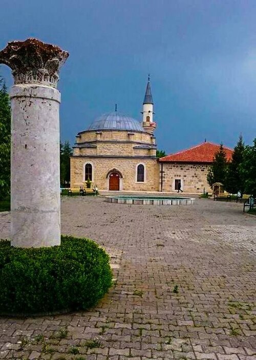
تشتهر منطقة ساريكايا بحمامها الحراري الذي يعود إلى العصر الروماني ، والذي يشار إليه غالبًا باسم حمام ساريكايا الروماني ، وهو جزء من القائمة المؤقتة لليونسكو ويعتبر أحد أهم الأمثلة على العمارة الحرارية الرومانية في الأناضول . [ 39 ]
توفر المناطق الطبيعية مثل منتزه تشامليك الوطني، الواقع بالقرب من مركز المدينة، مساحات ترفيهية للسكان والزوار. وقد أُنشئ هذا المنتزه كأول منتزه وطني في تركيا، وهو وجهة شهيرة للنزهات والمشي والأنشطة الخارجية. [ 40 ]
لا تزال السياحة في المدينة محدودة نسبياً مقارنة بالوجهات التركية الرئيسية، لكنها تتطور تدريجياً من خلال الاستثمارات في البنية التحتية والترويج لمواقع التراث الثقافي.
ثقافة
تعكس الحياة الثقافية في يوزغات تقاليد وسط الأناضول ، ولا سيما تلك المرتبطة بمنطقة بوزوك التاريخية. ولا تزال الموسيقى الشعبية، بما فيها الأغاني التي تُؤدى على آلة الباغلاما ، عنصراً هاماً من عناصر التعبير الثقافي المحلي. كما تُؤدى الرقصات التقليدية، مثل رقصة الهالاي، بشكل شائع في حفلات الزفاف والاحتفالات المحلية. [ 41 ]
تُقام الفعاليات والمهرجانات الثقافية بشكل دوري في المدينة، وغالباً ما تنظمها السلطات المحلية والجامعات، بما في ذلك جامعة يوزغات بوزوك ، التي تساهم في الحياة الثقافية والأكاديمية للمدينة. [ 42 ]
مطبخ
Local cuisine includes dishes typical of Central Anatolian cuisine, such as testi kebabı, keşkek, and arabaşı çorbası (arabaşı soup). Yozgat is particularly known for Yozgat Tandır Kebabı, a traditional lamb dish slow-cooked in a stone oven, which is regarded as one of the region's signature dishes. Another local specialty is Parmak Çöreği ("finger-shaped bread"), a traditional pastry and baked bread product associated with the region. Agricultural products from the surrounding countryside also play an important role in everyday food culture.[43]
Madımak yemeği, prepared from the wild edible herb Polygonum cognatum (madımak), is a traditional dish widely consumed in Yozgat and other parts of Central Anatolia, where it is typically cooked with bulgur, onions, and seasonings.[44]
Another traditional dessert associated with Yozgat is İncir Uyutması, also known as fig pudding, a milk-based sweet prepared from dried figs and milk, which is left to thicken naturally during a resting process from which it takes its name.[45]

Grapes
Grapes have long formed part of Yozgat's rural culture and culinary traditions. Vineyards are cultivated in various parts of the province, particularly in districts such as Çekerek and Sorgun, where grape growing remains a traditional agricultural activity. Grapes are consumed fresh and are also processed into products such as pekmez (grape molasses), which is traditionally prepared during the autumn grape harvest using methods passed down through generations. The production of grape-based products continues to be associated with village life and seasonal traditions in many parts of the province.[46][47]
Grape leaves (asma yaprağı) are commonly used in Yozgat cuisine, particularly in the preparation of stuffed vine leaves (yaprak sarma), a traditional dish widely consumed throughout Central Anatolia. The dish is typically prepared with rice, herbs and spices, and is frequently served during family gatherings, religious holidays and local celebrations.[48]
Sights


The main sights of the city of Yozgat are the Yozgat Clock Tower built in 1908 and the Çapanoğlu Mosque built by the Çapanoğlu family, who are the founders of Yozgat. Yozgat Pine Grove National Park is an area of 264 ha (2.64 km2) in which different types of pine trees grow, some up to 500 years old.

Archeology
The first surveys were started in the year 1993. Since then archaeologists have uncovered countless artifacts belonging to 5 different ancient civilizations from the area and as well as artifacts that belong to 5 different eras – Bronze Age, Hellenistic, Hittite, Copper and Upper Byzantine eras.
Surface excavations and surveys were also undertaken on the Kerkenes plateau by Dr. Geoffery Summers, a British archaeologist. The plateau is believed to be the home to the lost city of Pteria. The search for this lost city as well as other old world constructions began in 2013, and it plans to go on till the month of August as well. The expedition covers an area which is surrounded by walls and is known to date back to almost 2600 years.
According to historical reports, Pteria was destroyed, burned and abandoned during the Battle of Pteria between the Lydians and the Medes. This battle ended during a solar eclipse on 28 May 585 BC, and it was understood to be an omen that the gods wanted the fighting to stop.
Another excavation site in the region that deserves to be mentioned is in KuşakluTumulus. A team headed by Dr. Stefania Mazzoni has been working at the site since the year 2008, and it is believed that the Hittite civilization as well as the city of Zippalandawas once existed in the region. As a part of these excavations a 2000-year-old Roman bath that was said to be used to heal people from their wounds has been discovered. Traces of the Roman, Seljuq, Byzantine and Ottoman eras have also been found in the region.
With so much of history yet to be uncovered from a single city, archaeologists remain hopeful of unearthing many more wonders of the ancient world in the next few months. It has already been proved that the area was home to numerous civilizations that date all the way back to the Roman era. Archaeologists remain hopeful of managing to unearth many more old world structures and secrets as time passes by.
بعد أن أصبح المركز الإداري القديم للمنطقة، تافيوم ( بويوكنيفس )، مدمرًا، تم إنشاء مركز جديد بواسطة تشابان أوغلو ، مؤسس عائلة ديريباي القوية ، وأطلق عليه اسم بوزوك . [ 49 ]
يُعتقد أن كورنياسبا ، وهي مستوطنة رومانية وبيزنطية تقع على الطريق بين تافيوم وسيباستيا ، كانت تقع بالقرب من يوزغات الحديثة . [ 50 ]
الجغرافيا
تقع يوزغات ضمن هضبة بوزوك، وهي منطقة جبلية تتميز بنباتات السهوب وغطاء غابي محدود نسبيًا. وقد دعمت المناظر الطبيعية المحيطة بها تاريخيًا ممارسات الزراعة الجافة ، ولا سيما زراعة الحبوب ورعي الماشية. [ 51 ]
تمثل حديقة تشامليك الوطنية، الواقعة بالقرب من مركز المدينة، واحدة من أقدم الحدائق الوطنية في تركيا ، وتحافظ على بقايا غابات الصنوبر الطبيعية ضمن بيئة سهوب الأناضول الوسطى . [ 52 ]

تقع بلدة يوزغات على ارتفاع 1335 مترًا (4380 قدمًا)، على بُعد 170 كيلومترًا (105 أميال) شرق أنقرة ، بالقرب من منبع وادٍ ضيق يمر عبره طريق أنقرة-سيواس. ومثل معظم هضبة الأناضول ، تعرضت الأراضي المحيطة بيوزغات لإزالة الغابات على مدى آلاف السنين من الاستيطان البشري، مما يجعل مناخها قاسيًا صيفًا وشتاءً. ومع ذلك، فقد اتخذت تركيا خطوات جادة لإعادة تشجير جزء على الأقل من المنطقة.
مناخ
تتمتع يوزغات بمناخ قاري ( كوبن : Dsb ، تريوارثا : Dc ) يتميز بشتاء بارد ومثلج وصيف دافئ وجاف. ويبلغ متوسط درجة الحرارة في أحر شهور السنة 26 درجة مئوية (79 درجة فهرنهايت) خلال النهار. وقد تنخفض درجات الحرارة في الشتاء إلى -20 درجة مئوية (-4.0 درجة فهرنهايت) في ذروة الموسم.
| بيانات المناخ لمنطقة يوزغات (1991-2020، الظواهر المناخية المتطرفة 1929-2023) | |||||||||||||
|---|---|---|---|---|---|---|---|---|---|---|---|---|---|
| شهر | يناير | فبراير | مار | أبريل | يمكن | يونيو | يوليو | أغسطس | سبتمبر | أكتوبر | نوفمبر | ديسمبر | سنة |
| أعلى درجة حرارة مسجلة بالدرجة المئوية (الفهرنهايت) | 15.4 (59.7) | 18.5 (65.3) | 25.0 (77.0) | 29.5 (85.1) | 31.4 (88.5) | 33.1 (91.6) | 38.8 (101.8) | 37.4 (99.3) | 35.4 (95.7) | 30.1 (86.2) | 22.9 (73.2) | 18.2 (64.8) | 38.8 (101.8) |
| متوسط درجة الحرارة العظمى اليومية بالدرجة المئوية (الفهرنهايت) | 2.8(37.0) | 4.7(40.5) | 9.1(48.4) | 14.5(58.1) | 19.5(67.1) | 23.6(74.5) | 27.1(80.8) | 27.5(81.5) | 23.7(74.7) | 17.8(64.0) | 10.7(51.3) | 4.9(40.8) | 15.5(59.9) |
| Daily mean °C (°F) | −1.3(29.7) | −0.1(31.8) | 3.7(38.7) | 8.8(47.8) | 13.4(56.1) | 17.2(63.0) | 20.3(68.5) | 20.6(69.1) | 16.6(61.9) | 11.5(52.7) | 5.0(41.0) | 0.7(33.3) | 9.7(49.5) |
| Mean daily minimum °C (°F) | −4.8(23.4) | −4.1(24.6) | −0.8(30.6) | 3.5(38.3) | 7.8(46.0) | 11.3(52.3) | 13.8(56.8) | 14.2(57.6) | 10.4(50.7) | 6.3(43.3) | 0.5(32.9) | −2.6(27.3) | 4.6(40.3) |
| Record low °C (°F) | −23.7(−10.7) | −24.4(−11.9) | −20.6(−5.1) | −12.6(9.3) | −3.0(26.6) | −0.4(31.3) | 3.0(37.4) | 3.7(38.7) | −2.4(27.7) | −6.8(19.8) | −18.5(−1.3) | −20.2(−4.4) | −24.4(−11.9) |
| Average precipitation mm (inches) | 66.4(2.61) | 58.1(2.29) | 70.7(2.78) | 58.4(2.30) | 68.8(2.71) | 47.1(1.85) | 12.8(0.50) | 16.9(0.67) | 22.0(0.87) | 40.4(1.59) | 57.4(2.26) | 76.7(3.02) | 595.7(23.45) |
| Average precipitation days | 13.93 | 13.33 | 13.93 | 13.27 | 13.9 | 10.2 | 3.2 | 2.83 | 4.67 | 8.23 | 8.63 | 13.7 | 119.82 |
| Average relative humidity (%) | 78.6 | 74.9 | 69.9 | 65.1 | 65.0 | 62.8 | 57.2 | 56.9 | 58.6 | 66.1 | 71.6 | 78.0 | 67.0 |
| Mean monthly sunshine hours | 95.2 | 117.4 | 156.2 | 194.4 | 242.9 | 282.7 | 328.0 | 317.0 | 249.4 | 194.2 | 143.8 | 86.8 | 2,408 |
| Mean daily sunshine hours | 3.1 | 4.3 | 5.1 | 6.5 | 7.9 | 9.6 | 10.7 | 10.4 | 8.5 | 6.4 | 4.9 | 2.9 | 6.7 |
| Source 1: Turkish State Meteorological Service[53] | |||||||||||||
| Source 2: NOAA (humidity, sun 1991-2020)[54] | |||||||||||||
Sport

The city's football team Yozgatspor plays in the Turkish Regional Amateur League.
Notable people
- Agah Efendi (1832–1885), journalist, publisher of the first Turkish newspaper
- Nasuh Akar (1925–1984), Olympic gold medalist wrestler
- Celal Atik (1918–1979), Olympic gold medalist wrestler
- Bekir Bozdağ (1965), Deputy prime minister
- Cemil Çiçek (1946), Speaker of Turkish Grand National Assembly
- Aylin Daşdelen (1982), European champion female weightlifter
- John Ilhan (1965–2007), Turkish-Australian businessman
- Lütfullah Kayalar (1952), former Minister of Finance
- Soner Özbilen (1947), folk singer
- Bozoklu Mustafa Pasha (1693–1694), Ottoman Grand Vizier
- Yusuf Izzet Pasha (1876–1922), Ottoman and Turkish general
- Ahmet Şâhin (born 1935), writer[55]
- Mehmet Topuz (1983), footballer
- Mehmet Nidâ Tüfekçi (1929–1993), folk singer
- Mehmet Yıldız (1981), footballer
- Nubar Ozanyan (1956–2017), Turkish-born Armenian communist
- Hayko Cepkin (1978), Rock Singer
- İhsan Oktay Anar (1960), Author
- Rıza Kayaalp (1989), wrestler
Twin towns – sister cities
Yozgat is twinned with:


References
- 12"Address-based population registration system (ADNKS) results dated 31 December 2025". TÜİK. Retrieved 13 June 2026.
- ↑İl BelediyesiArchived 2015-07-06 at the Wayback Machine, Turkey Civil Administration Departments Inventory. Retrieved 22 May 2023.
- ↑"Yozgat". Encyclopaedia Britannica. Retrieved 8 June 2026.
- ↑"Yozgat İsminin Verilmesi". T.C. Yozgat Valiliği. Retrieved 5 June 2026.
- ↑Sezen, Tahir (2017). Osmanlı Yer Adları(PDF) (2nd ed.). Ankara: T.C. Başbakanlık Devlet Arşivleri Genel Müdürlüğü. p. 822. Retrieved 5 June 2026.
- ↑Richard Kiepert (1916). Karte von Kleinasien (Map).
- ↑"Γιωσγάτη - Yozgati". Pontos World. Retrieved 6 June 2026.
- ↑"Origin: Γιοζγάτη". 100 Objects of Asia Minor Hellenism. National Hellenic Research Foundation. Retrieved 6 June 2026.
- ↑"Badrig Arakelian, told by his daughter, Mary Ann Arakelian Kazanjian". Armenian Museum of America. Retrieved 11 June 2026.
- ↑"Yozgat". Wiktionary. Retrieved 11 June 2026.
- ↑"Yozgat". Armeniapedia. Retrieved 11 June 2026.
- ↑"History of Yozgat". Yozgat Tourism and Promotion Portal. Retrieved 5 June 2026.
- ↑"BOZOK". TDV İslâm Ansiklopedisi. Retrieved 5 June 2026.
- ↑"ÇAPANOĞLU CAMİİ". TDV İslâm Ansiklopedisi. Retrieved 5 June 2026.
- ↑Erdoğan, Serkan; Uyak, Serap (2022). "Yozgat in Ancient Times in the Light of Archaeological Researches and Written Documents". Kültür Araştırmaları Dergisi.
- ↑"History of Yozgat". Yozgat Tourism and Promotion Portal.
- ↑"Yozgat". Encyclopædia Britannica.
- ↑"History of Yozgat". Yozgat Tourism and Promotion Portal.
- ↑Steuer, Kenneth. "Pursuit of an 'Unparalleled Opportunity'". pp. Appendix A. Retrieved 18 September 2016.
- ↑"Jones, Elias Henry". Dictionary of Welsh Biography. National Library of Wales. Retrieved 18 September 2016.
- ↑"Address-based population registration system (ADNKS) results". Turkish Statistical Institute (TÜİK). Retrieved 5 June 2026.
- ↑"Yozgat Province General Information". Yozgat Governorship. Retrieved 5 June 2026.
- ↑"Yozgat". Encyclopædia Britannica. Retrieved 5 June 2026.
- ↑"Yozgat (Merkez) Population Statistics". CityPopulation.de (based on TÜİK data). Retrieved 8 June 2026.
- ↑"Yozgat'a Nasıl Gidilir? Ulaşım Rehberi". Retrieved 5 June 2026.
- ↑"Yozgat Ulaşım". Yozgat Provincial Directorate of Culture and Tourism. Retrieved 5 June 2026.
- ↑"Yozgat Hattusas Airport to commence operations in 2026". CAPA – Centre for Aviation. 11 June 2025. Retrieved 7 June 2026.
- ↑"Yozgat Havalimanı'nın İnşaatı Hızla Devam Ediyor". Haberler.com. 16 August 2025. Retrieved 7 June 2026.
- ↑"How to Come? Route Yozgat". Yozgat Tourism and Promotion Portal. Retrieved 5 June 2026.
- ↑"About Yozgat Bozok University". Yozgat Bozok University. Retrieved 5 June 2026.
- ↑"Yozgat Provincial Directorate of National Education". Ministry of National Education (Turkey). Retrieved 5 June 2026.
- ↑"Yozgat – UNESCO Global Network of Learning Cities". UNESCO Institute for Lifelong Learning. Retrieved 7 June 2026.
- ↑"Regional Statistics – Yozgat". Turkish Statistical Institute (TÜİK). Retrieved 5 June 2026.
- ↑"Yozgat Organized Industrial Zone". Retrieved 5 June 2026.
- ↑"Importance of Cereals and Pulses in Agricultural Production of Yozgat". Bozok University Symposium Proceedings (via ResearchGate). Retrieved 8 June 2026.
- ↑"Yozgat Agriculture Overview". Yozgat Provincial Directorate of Culture and Tourism. Retrieved 5 June 2026.
- ↑"Yozgat". Encyclopædia Britannica. Retrieved 5 June 2026.
- ↑"Yozgat Tourism Information". Yozgat Provincial Directorate of Culture and Tourism. Retrieved 5 June 2026.
- ↑"Sarıkaya Roman Bath". UNESCO World Heritage Centre. Retrieved 5 June 2026.
- ↑"Çamlık National Park". Yozgat Provincial Directorate of Culture and Tourism. Retrieved 5 June 2026.
- ↑"Yozgat Cultural Overview". Yozgat Provincial Directorate of Culture and Tourism. Retrieved 5 June 2026.
- ↑ "أحداث جامعة يوزغات بوزوق" . جامعة يوزغات بوزوك . تم الاسترجاع في 5 يونيو 2026 .
- ↑ "مطبخ يوزغات" . بوابة يوزغات للسياحة والترويج . تم الاطلاع عليه بتاريخ 5 يونيو 2026 .
- ^ "ماديماك يميجي" . وزارة الثقافة والسياحة . تم الاسترجاع في 8 يونيو 2026 .
- ↑ "إنسير أويوتماسى" . روتا يوزغات . تم الاسترجاع في 8 يونيو 2026 .
- ↑ "Şifa deposu üzüm pekmezinin sofralara yolculuğu sürüyor" . فكريات. 11 أكتوبر 2022 . تم الاسترجاع في 6 يونيو 2026 .
- ↑ "تركيا: العنب يتحول إلى دبس السكر في يوزغات" . تريدج. 13 أكتوبر 2023. تم الاطلاع عليه بتاريخ 6 يونيو 2026 .
- ↑ "مطبخ يوزغات" . مديرية الثقافة والسياحة في مقاطعة يوزغات . تم الاطلاع عليه بتاريخ 5 يونيو 2026 .
- ↑ تشيشولم، هيو ، محرر. (1911). . الموسوعة البريطانية . المجلد 28 ( الطبعة الحادية عشرة). مطبعة جامعة كامبريدج. ص 947.
- ↑ سردار دينسر، بينار؛ دوغاندور، امري (2024). “مستوطنة منسية على الطرق البيزنطية: كورنياسبا”. Ortaçağ Araştırmaları Dergisi . 7 (1): 62– 82. دوى : 10.48120/oad.1374604 .
- ↑ "جغرافيا يوزغات" . وزارة الثقافة والسياحة في جمهورية تركيا . تم الاطلاع عليه بتاريخ 8 يونيو 2026 .
- ↑ "منتزه تشامليك الوطني" . وزارة الزراعة والغابات . تم الاطلاع عليه بتاريخ 8 يونيو 2026 .
- ^ “Resmi İstatistikler: İllerimize Ait Mevism Normalleri (1991-2020)” (باللغة التركية). هيئة الأرصاد الجوية الحكومية التركية . تم الاسترجاع في 7 أغسطس 2021 .
- ↑ "المتوسطات المناخية لمنظمة الأرصاد الجوية العالمية للفترة 1991-2020 - يوزغات" . الإدارة الوطنية للمحيطات والغلاف الجوي . تم الاطلاع عليه في 17 يناير 2024 .
- ^ "أحمد شاهين" . kidega.com (باللغة التركية). Kidega Elektronik Ticaret ve Yayılık A.Ş. مؤرشفة من الأصلي في 8 ديسمبر 2021 . تم الاسترجاع 18 يوليو 2023 .
- ↑"Yozgatlılar Kardeş Kentlerimizi Biliyor Musunuz?". Yozgat Hakimiyet. Retrieved 9 June 2026.
- ↑"Yozgatlılar Kardeş Kentlerimizi Biliyor Musunuz?". Yozgat Hakimiyet. Retrieved 9 June 2026.
- ↑"Yozgatlılar Kardeş Kentlerimizi Biliyor Musunuz?". Yozgat Hakimiyet. Retrieved 9 June 2026.
- Yozgat
- Yozgat District
- Provincial municipalities in Turkey
- Populated places in Yozgat Province