
Acolman
Acolman de Nezahualcóyotl is a town and municipality located in the northern part of State of Mexico, part of the Greater Mexico City area, just north of the city proper. According to myth, the first man was placed here after being taken out of Lake Texcoco. In the community of Tepexpan, the fossilized bones more than 12,000 years old of a man were found in the 20th century. The settlement was founded in the eighth century and was an important commerce center at the time of the Spanish conquest of the Aztec Empire.[1]
After the Spanish conquest of the Aztec Empire, Acolman became the site of an important Augustinian monastery in the 16th century that still contains important art and architecture from that time period.[2]
History
According to an ancient myth, when the gods created the first man, they took him from the waters of Lake Texcoco and placed him alone in Acolman. The arm of this man, ringed by drops of water from the lake is the Aztec glyph for the site. The glyph can also be seen on the monastery which dominates the landscape here.[3] Acolman is derived from a Nahuatl phrase which has been interpreted in various ways. It may mean "man with hand or arm" or "where man is made." Acolman is the modern name but the settlement has been referred to as Oculma, Axuruman and Aculma in colonial era documents.[1]
The municipality is home of the Tepexpan man, named after the community in which he was found. The Tepexpan man is a Subboreal Holocene human[4] fossilized skeleton that was found in the mid-20th century.[1]
يُنسب تأسيس مستوطنة أكولمان إلى شعب أكولواس ، أحد شعوب تشيتشيميكا ، حوالي القرن الثامن الميلادي. بدأت المستوطنة مستقلة، لكنها خضعت أولًا لسيطرة شعب هوكسوتزينكا ، وظلت خاضعة لحكم مختلف منذ ذلك الحين. وبحلول عهد تلاتواني نيزاهوالكويوتل ، كانت أكولمان مدينة مهمة في منطقة تيتزكوكو ألتيبيتل بعد أن غزاها الأزتيك عام 1396. اكتسبت المدينة أهمية بالغة لكونها المكان الوحيد في أمريكا الوسطى المتخصص في تربية الكلاب (المعروفة اليوم باسم سلالة زولو إيتزكوينتلي ). [ 1 ]
عند الغزو الإسباني، كانت أكولمان تحت حكم موكتيزوما الثاني . بعد ذلك، أصبحت أكولمان إقطاعيةً لبيدرو دي سوليس دي لوس مونتيروس وابنه فرانسيسكو. وصل الفرنسيسكان أولًا، لكن الأوغسطينيين تولوا مسؤولية جهود التبشير بعد عام ١٥٣٩، حيث بلغ عددهم أربعة وعشرين راهبًا مقيمين بحلول عام ١٥٨٠. وقد شيدت هذه الرهبنة أحد أهم الأديرة في الحقبة الاستعمارية المبكرة في إسبانيا الجديدة هنا. [ ١ ] [ ٢ ]
شهد القرنان السابع عشر والثامن عشر فيضانات عارمة، تسببت بأضرار واسعة النطاق ونزوح جماعي للسكان. وأدت هذه الفيضانات في نهاية المطاف إلى اختفاء بلدات قرب أكولمان، مثل تلاكويلوكان وتزابوتلا وتيسكازونكو. [ 1 ] وفي إحدى محاولات السيطرة على الأنهار في المنطقة، شُيّد سدٌّ ألحق دمارًا كبيرًا بالمنطقة. وخلال إحدى الفيضانات، غمرت المياه الدير لأكثر من ستة أقدام، فغطت أرضية الكنيسة بالطمي وكادت أن تدمر أروقتها. [ 2 ] وفي القرنين السابع عشر والثامن عشر، فتكت الأوبئة، مثل الجدري، بالسكان الأصليين. [ 1 ]
بعد حرب الاستقلال المكسيكية ، أصبحت أكولمان مقرًا لبلدية تحمل الاسم نفسه. وفي عام 1876، ونظرًا لعدم الاستقرار السياسي، نُقل المقر مؤقتًا إلى بلدة تُدعى زوميتلا. وفي عام 1877، عاد المقر إلى أكولمان وأُضيف إليه اسم "دي نيزاهوالكويوتل". [ 1 ]
في عام 1925، ضرب فيضان آخر البلدية وألحق أضراراً بالدير، ولكنه حفز أيضاً بدء جهود الترميم التي استمرت حتى نهاية القرن العشرين. وأُعلن الدير معلماً وطنياً في عام 1933. [ 1 ] [ 2 ]
مرّت شعلة دورة الألعاب الأولمبية الصيفية لعام 1968 من هنا في طريقها إلى مدينة مكسيكو. [ 1 ]
المدينة وديرها
المدينة
أهم ما يميز المدينة بلا منازع هو دير سان أغوستين السابق، الواقع بجوار الساحة الرئيسية. ومع ذلك، توجد معالم جذب أخرى أيضًا. تضم المكتبة المركزية ودار الثقافة لوحات ومنحوتات لفنان من أبناء أكولمان يُدعى بارمينو. وفي السوق البلدي ، يمكن العثور على أطعمة مثل الميكسيوت والبارباكوا والكونسومي والديك الرومي مع صلصة المول ، بالإضافة إلى مشروب البولكي . [ 1 ]
تشمل المهرجانات الرئيسية عيد القديس نيكولاس في 10 سبتمبر، وعيد رئيس الملائكة ميخائيل في 29 سبتمبر، وعيد سيدة غوادالوبي في 12 ديسمبر. ويتم الاحتفال بهذه الأعياد بالرقصات التقليدية مثل الكونشيروس والأريروس والكونترادانس والباستوريس والإنديتوس والتيوماتيس، بالإضافة إلى الألعاب النارية والألعاب الترفيهية والموسيقى. [ 5 ]
يُعدّ مهرجان "فيريا دي لا بوسادا إي لا بينياتا" (معرض البينياتا ولاس بوساداس ) أبرز مهرجانات المدينة ، ويُقام فيها كل ديسمبر منذ عام ١٩٨٥. [ ٦ ] وتدّعي أكولمان أنها مهد تقليد لاس بوساداس في المكسيك، فضلاً عن كونها "مهد" البينياتا، إذ يعود تاريخها إلى أكثر من ٤٢٠ عامًا. ويُصنع فيها نوعان من البينياتا: المصنوعة من الفخار، وتلك المصنوعة بالكامل من الورق. [ ٥ ] ويتجمع المشاركون من مختلف المجتمعات في المنطقة، والفعالية الرئيسية هي مسابقة البينياتا. كما تُقام سباقات الخيل، ومصارعة الثيران، ومشاهد ميلاد السيد المسيح، وعروض "باستوريلاس" المسرحية المستوحاة من موسم عيد الميلاد، والرقصات الشعبية، وعروض الموسيقى الشعبية. [ ٦ ] ويُعدّ سباق الخيل تقليدًا يعود إلى الثورة المكسيكية . [ ٥ ]
الدير
أُعلن دير سان أغوستين نصبًا تذكاريًا وطنيًا عام 1933، [ 7 ] وقد بُني بين عامي 1539 و1580، حيث أُنجز معظم العمل بعد عام 1550. جدرانه مبنية من الحجارة غير المنتظمة ومغطاة بالجص، تعلوها أسوار ، ويُضفي عليه مظهره العام طابع الحصن. [ 2 ] [ 5 ] [ 8 ] تُشير الأسوار، وبرج الجرس الوحيد، والكنيسة المفتوحة، والواجهة البلاتيرسكية إلى أن هذا المجمع يُعدّ بناءً دينيًا كلاسيكيًا من القرن السادس عشر. لم يكن مظهر الحصن في مجمعات ذلك العصر يهدف حرفيًا إلى الحماية، بل كان يهدف إلى إضفاء هيمنته على المشهد الطبيعي، كما هو الحال مع قلاع العصور الوسطى في أوروبا. في المناطق التي وُجدت فيها أحجار مُرصّعة بعناية، نُحتت هذه الأحجار. [ 2 ] يُنسب بناء الدير إلى أندريس دي أولموس . [ ٧ ] بدأت أعمال الترميم في هذا المجمع منذ عشرينيات القرن الماضي، مما كشف عن واجهة الكنيسة بالكامل، كما تم تسوية ردهة الكنيسة إلى مستوى بنائها الأصلي. وقد كشف هذا عن أضرار الفيضانات التي لحقت بها خلال الحقبة الاستعمارية. وكانت معظم اللوحات الجدارية والرسومات قد دُفنت تحت طبقات من الجص والدهانات لسنوات قبل ترميمها. [ ٢ ]
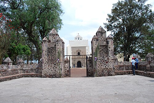
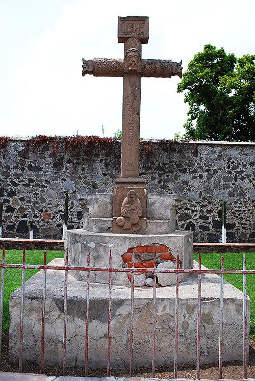
The complex is fronted by a large square atrium, and a courtyard before that, the two of which are today separated by a road[2][8] The most important feature of this atrium area is the 2.4 metres (7 ft 10 in) high stone cross, which is considered to be an important expression of "tequitqui" or Christian art executed by Indian craftsmen from the very early colonial period. The cross was mostly likely erected between the time that the Franciscans occupied the site and before the architectural sculptures of the current complex.[2] The cross is decorated with plants, flowers and flames at the top (which allude to the Passion of Christ) all sculpted into the stone.[5] There is also a melancholy, mask-like face of Christ, with crown of thorns which projects from the center of the cross.[3] At the foot of the stone cross is a Madonna figures who has been identified as the Virgin of Sorrows and even associated with the goddess Coatlicue.[2][3] At the feet of this Virgin is a weathered stone skull and a serpent, and in her breast is imbedded a dark stone disk. This follows the Aztec tradition of placing jades or other precious stones in their statues to symbolize the soul.[3]
To the back of the atrium area is the main church, with its rose/tan Plateresque facade reminiscent of the Colegiata de Santa María in Calatayud, Spain. The facade has Classical composite columns with Plateresque sections below the ribbon garniture, Saint Paul under a deep, Gothic-like canopy with a Renaissance angel below. The portal has double Renaissance doors under archivolts decorated with fruit. Above the doors are seahorses on the main frieze and Moorish paneling on the doors themselves.[2] This facade was mostly likely created by Spanish craftsmen and had significant influence on other Augustinian church fronts in New Spain, especial at Yuriria and Cuitzeo in Michaocán and at Metztitlán in Hidalgo.[3] The church building is 62.5 metres (205 ft) long, 17.1 metres (56 ft) wide and 21.3 metres (70 ft) high,[2] with the interior walls particularly high[5][8] The interior vault was modified and the interior pilasters and exterior buttresses were added in 1735. The main altarpiece dates from 1690 and was put here in the 20th century to replace the original. The side altarpieces date from the 18th century.[2] These Baroque altarpieces are all sculpted in wood and gilded, decorated with plants, flower, celestial figures and angels.[5] The presbytery has a late medieval ribbed vault and important frescos in black, white and orange, with images of saints on thrones, priests and Augustine popes.[2][5]
The small open chapel, or chapel of the Indians is located on the upper part of the wall between the church and the main portal to the cloister area. This chapel contains two murals from the 16th century by unknown authors depicting the Last Judgement and Catherine of Alexandria.[5][7]
The monastery consists of two cloisters. The Claustro Chico or small cloister is of simple architecture, constructed in stone with a cross in the center which has an anagram of Jesus' name. The Claustro Grande or large cloister (also called the Naranjo or Orange Tree cloister) has a more elaborate Plateresque design with "Isabelino" type columns.[5][7] The small cloister may date from the Franciscan period or might be part of the early Augustinian church. Flatted arches on piers with a barrel-vaulted corridor on the ground level and a wood-roofed second level suggest the simple construction of the very early colonial period. Primitive frescos decorate the walls. The stone cross here is very similar to the Franciscan cross at one of the earliest monasteries in Cuernavaca. The crucifixion fresco on the second level is inspired by various European sources of the 15th and 16th centuries such as German prints, Italian and German ornamental panels. Starkly done in black and white, it reflects the continuing importance of the graphic arts. It also has sun and moon designs, common during the early colonial period, which reflect both old European astrological symbols as well as the importance of these in native art.[2] In the larger, more ornate, cloister, there are medallions with images such as the coat of arms of the Augustine order, a symbol for death, and a symbol representing the union of two worlds. The lower floor has a series of stone etchings with scenes related to the Passion of Christ.[5]
Museo Virrenal
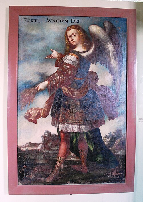
Much of the cloister area is occupied by the "Museo Virrenal" (Colonial Era) founded in 1925 in what were the portico, the kitchen the refectory and the hallway to the refectory. It has three main halls which give a detailed explanation of the construction of the site, the lives of the monks and the collection of paintings and religious objects that are on display. The museum contains more than 120 pieces. Many of the religious artwork and objects are in the third hall and include furniture, cloaks, and other religious garb (some embroidered in gold thread), sculptures in stone, wood and corn stalk paste, and oils from the 16th to the 19th centuries.[5][7]
A website has been created by INAH to allow for the virtual visitation of the museum. The tour is a series of 360 degree panoramic views of each of the rooms and the pre-Hispanic base over which the monastery was built. Some of the restored rooms that are visible this way include the kitchen and the dispensary. The church is also accessible in this manner.(virtual) The site is at http://www.inah.gob.mx y http://culturainah.org/panorama360/acolman/[7]
The municipality
As municipal seat, the town of Acolman is the governing authority for over sixty other named communities,(inegi) which cover a total area of 86.88 km2.[1] At the 2010 census, the total population of the municipality was 136,558, but only about four percent of this population lives in the town proper.(inegi) The municipality borders the municipalities of Tecámac, San Juan Teotihuacán, San Salvador Atenco, Tezoyuca, Chiautla, Tepetlaoxtoc and Ecatepec.[1]
Towns and villages
The municipal seat, Acolman de Nezahualcóyotl, has a population of 5,571 inhabitants, while the largest city (locality) in the municipality, Tepexpan, has a population of 102,667, more than 18 times as big. This is the largest relative difference between any municipal seat and its largest locality of any municipality in Mexico. The largest localities (cities, towns, and villages) are:[9]
| Name | 2010 Census Population |
|---|---|
| Tepexpan | 102,667 |
| Acolman de Nezahualcóyotl | 5,571 |
| Santa Catarina | 5,116 |
| San Bartolo | 5,099 |
| San Miguel Xometla | 4,571 |
| San Marcos Nepantla | 4,116 |
| Prados de San Juan | 3,081 |
| San Pedro Tepetitlán | 2,805 |
| Total Municipality | 136,558 |
تقع البلدية على سهل في الجزء الشمالي من وادي المكسيك ، المعروف بوادي تيوتيهواكان. لا تضم سوى ثلاث مرتفعات رئيسية. يحدها من الشرق سلسلة جبال سييرا دي باتلاتشيك ، ومن الغرب جبل تشيكوناوتلا. تشيكوناوتلا وتلاهويلكو منطقتان غابيتان محميتان. تتدفق من الجبال المحيطة بهذا السهل عدة جداول، مثل سان خوسيه وسان أنطونيو، واللذان يُعرفان باسم ريو غراندي وريو تشيكو على التوالي. تفتقر البلدية إلى ينابيع المياه العذبة، حيث تُستمد معظم مياه الشرب من الآبار العميقة. يتميز مناخها بالاعتدال وشبه الجفاف مع هطول أمطار في الصيف. تتراوح درجات الحرارة بين 36 درجة مئوية في الصيف و-4 درجات مئوية في الشتاء. تضم المناطق الحرجية في البلدية أشجارًا مثل الأهويويتي ، والمِسْكيت ، والأوكالبتوس، والفلفل البيروفي . في المناطق المنخفضة والمسطحة، تتكون النباتات من الشجيرات والأعشاب والصبار ونباتات أخرى متأقلمة مع المناطق الجافة. أما الحياة البرية فتتكون في الغالب من الثدييات الصغيرة مثل الأرانب والظربان ، والزواحف الصغيرة مثل الحرباء، والحشرات. [ 1 ]
ترتبط البلدية بطريق ليتشيريا-تيكسكوكو السريع ، الذي يبدأ من ملتقى طريقي بينيون-تيكسكوكو ولوس رييس-تيكسكوكو السريعين. كما ترتبط المدينة بمناطق أخرى مثل تيوتيهواكان، وباتشوكا (هيدالغو) على مسافة أبعد.
الجغرافيا
مناخ
| بيانات المناخ لأكولمان دي Nezahualcóyotl | |||||||||||||
|---|---|---|---|---|---|---|---|---|---|---|---|---|---|
| شهر | يناير | فبراير | مار | أبريل | يمكن | يونيو | يوليو | أغسطس | سبتمبر | أكتوبر | نوفمبر | ديسمبر | سنة |
| متوسط درجة الحرارة العظمى اليومية بالدرجة المئوية (الفهرنهايت) | 20 (68) | 22 (72) | 24 (75) | 25.7 (78.3) | 25.8 (78.4) | 24.3 (75.7) | 23.4 (74.1) | 23.3 (73.9) | 22.5 (72.5) | 22.0 (71.6) | 21.3 (70.3) | 20.5 (68.9) | 22.9 (73.2) |
| متوسط الحد الأدنى اليومي °م (°ف) | -0.2 (31.6) | 1.3 (34.3) | 3.1 (37.6) | 5.6 (42.1) | 7.1 (44.8) | 8.7 (47.7) | 8.2 (46.8) | 7.7 (45.9) | 8.1 (46.6) | 5.4 (41.7) | 1.8 (35.2) | -0.2 (31.6) | 4.7 (40.5) |
| متوسط هطول الأمطار بالمليمتر (بوصة) | 2.5 (0.1) | 5.1 (0.2) | 13 (0.5) | 20 (0.8) | 38 (1.5) | 120 (4.7) | 120 (4.6) | 99 (3.9) | 99 (3.9) | 48 (1.9) | 13 (0.5) | 0 (0) | 570 (22.5) |
| المصدر: Weatherbase [ 10 ] | |||||||||||||
اقتصاد
تُخصص معظم أراضي البلدية للزراعة. تشمل المحاصيل الرئيسية الشعير والذرة والذرة الرفيعة والقمح والصبار وأنواعًا مختلفة من الخضراوات. كما توجد بساتين تُنتج الكابولين والخوخ والإجاص والتين والبرقوق والسابوت الأبيض والتيجوكوت والمشمش . وتشمل الثروة الحيوانية الأبقار والخنازير والماعز والدواجن. أما ثاني أهم نشاط اقتصادي فهو الصناعة، التي تُنتج الأغذية المصنعة والمشروبات ومنتجات التبغ والمنتجات الجلدية. ويقتصر التعدين على الحصى والرمل ومواد البناء الأخرى. توجد رواسب صغيرة من الذهب والفضة والنحاس والكوارتز والزئبق، لكنها لم تُستغل بعد. تقع معظم المناجم بالقرب من بلدتي سان بيدرو تيبتيتلان وزوميتلا. وتقتصر التجارة في الغالب على تلبية الاحتياجات المحلية. [ 1 ]
تعتمد بلدية أكولمان بشكل محدود على الصناعة والزراعة، حيث لا تزال معظم الأراضي الزراعية خاضعة لنظام الإيجيدو . وتُعدّ أكولمان منطقة سكنية، إذ يتنقل العديد من سكانها العاملين إلى أماكن أخرى مثل مدينة مكسيكو سيتي ومدن أخرى في ولاية المكسيك. [ 11 ] ويعمل أقل من 10% من سكان البلدية في الزراعة، بينما يتوزع الباقون بالتساوي بين الصناعة والتجارة. [ 1 ] وقد كان النمو السكاني فيها أبطأ بكثير من مناطق أخرى في مدينة مكسيكو سيتي. [ 11 ]
في عام ٢٠٠٨، منحت وكالة موديز بلدية أكولمان تصنيف A3.mx (على مستوى المكسيك) وBa3 (على المستوى العالمي). ويعود سبب هذا التصنيف إلى أن البلدية، رغم امتلاكها مستوى معتدلاً من الديون وتطوراً مالياً مناسباً، إلا أنها واجهت بعض المشكلات الإدارية في السنوات الأخيرة. كما يعكس هذا التصنيف محدودية القاعدة الاقتصادية للمنطقة وحاجتها الماسة إلى البنية التحتية. إذ تحتاج البلدية إلى أعمال طرق بقيمة تتراوح بين ١٢.٥ و٢٥ مليون بيزو، وهو مبلغ لا تستطيع تمويله وتحتاج إلى مساعدة من ولاية المكسيك. وعلى عكس البلديات الأخرى في منطقة مكسيكو سيتي الكبرى، يعتمد نظام إمداد المياه في أكولمان على شبكة تضم تسعة عشر مورداً للمياه، ثلاثة منهم فقط مملوكون للبلدية. [ ١١ ]
السياحة
The main tourist attractions are the archaeological zone of Tepexpan, where the fossilized bones of the Tepexpan man were found, and the former monastery of San Agustin de Acolman.[1] The Tepexpan Museum is located in the community of the same name, famous due to the discovery of the "Tepexpan Man", a human skeleton which is more than 12,000 years old. It was found in 1945 by Dr. Helmut de Terra and Alberto R. Arellano. The museum exhibits mammoth remains as well as flint and obsidian tools.[5] Other attractions in the municipality include the former haciendas of San Antonio, Tepexpan and Nextlalpan.[1] The San Antonio Hacienda is one of the few colonial-era haciendas what has managed to preserve its original architecture. Today it operates as a recreational center.[5] The Castillo Dam was constructed in the 18th century. Other attractions include the "Cueva de los Gatos" cave,[1] and the Cuevas de la Amistad (Friendship Caves) has areas dedicated to medicinal herbs in addition to the caves. The Sierra de Patlachique is an eco-tourism park with facilities for picnicking, swimming, football, cycling and camping.[5]
One important community outside the seat is called Cuanalán, which is a Nahua community. Fewer than 500 people can still speak an indigenous language, but a number of traditions survive. The community of Cuanalán is noted for its musicians, especially those dedicated to wind instruments. The better known groups include Los Vasquez, Los Juárez and Los Chicanos.[1]
References
- 1234567891011121314151617181920"Enciclopedia de los Municipios de Mexico Estado de Mexico Acolman de Nezahualcóyotl" (in Spanish). Archived from the original on May 28, 2007. Retrieved March 28, 2010.
- 123456789101112131415Armstrong Baird, Joseph (1962). The Churches of Mexico 1530-1810. Los Angeles CA: University of California Press. pp. 82–83. ISBN 968-16-6706-9.
{{cite book}}: ISBN / Date incompatibility (help) - 12345"ACOLMAN: The Eden of the Americas". Exploring Colonial Mexico. Espadaña Press. Archived from the original on September 18, 2010. Retrieved March 28, 2010.
- ↑Lamb, Angela L.; Gonzalez, Silvia; Huddart, David; Metcalfe, Sarah E.; Vane, Christopher H.; Pike, Alistair W.G. (September 2009). "Tepexpan Palaeoindian site, Basin of Mexico: multi-proxy evidence for environmental change during the late Pleistocene–late Holocene". Quaternary Science Reviews. 28 (19–20): 2000–2016. doi:10.1016/j.quascirev.2009.04.001.
Here we report new AMS radiocarbon dates associated with the sedimentary succession at Tepexpan with ages between 19,110 ± 90 and 612 ± 22 14C years BP and a new uranium-series date for the skeleton with an age of 4700 ± 200 years BP that indicates a mid Holocene age.
- 123456789101112131415"Acolman, un pueblo con encanto en el Estado de México"[Acoman, a town with charm in Mexico State] (in Spanish). Mexico City: Mexico Desconocido magazine. Retrieved March 28, 2010.
{{cite web}}: CS1 maint: deprecated archival service (link) - 12"San Agustín Acolman, Estado de México Feria de la posada y la piñata" (in Spanish). Mexico: Dirrecion General de las Culturas Populares. December 7, 2009. Archived from the original on 26 April 2010. Retrieved March 28, 2010.
- 123456"Museo virtual Acolman"[Acolman virtual museum] (in Spanish). Mexico: INAH. October 2, 2009. Retrieved March 28, 2010.
- 123"Templo y ex Convento de San Agustín (Estado de México)"[Church and ex monastery of San Agustin (Mexico State)] (in Spanish). Mexico City: Mexico Desconocido magazine. July 2001. Retrieved March 28, 2010.
{{cite web}}: CS1 maint: deprecated archival service (link) - ↑2010 census tables: INEGIArchived May 2, 2013, at the Wayback Machine
- ^ "قاعدة الطقس: الطقس التاريخي لأكولمان دي نيزاهوالكويوتل، المكسيك" . قاعدة الطقس. 2011. تمت الاستعادة في 24 نوفمبر 2011.
- 1 2 3 مولينا ، خوسيه ألبرتو (25 يوليو 2008). "Moody's assigna calificación de emisor A3.mx al Municipio de Acolman (Estado de México)" [ درجة تعيين Moody's A3.mx لبلدية أكولمان (ولاية المكسيك) ] (PDF) (بالإسبانية). موديز . تم الاسترجاع 28 مارس، 2010 .
روابط خارجية
- أكولمان
- بلديات ولاية المكسيك