
Valley


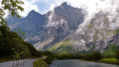
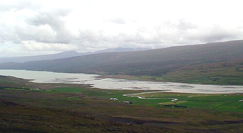
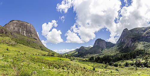
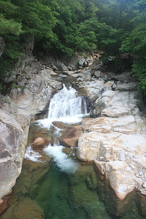
A valley is an elongated low area often running between hills or mountains and typically containing a river or stream running from one end to the other. Most valleys are formed by erosion of the land surface by rivers or streams over a very long period. Some valleys are formed through erosion by glacial ice. These glaciers may remain present in valleys in high mountains or polar areas.
At lower latitudes and altitudes, glacially formed valleys may have been created or enlarged during ice ages but now are ice-free and occupied by streams or rivers. In desert areas, valleys may be entirely dry or carry a watercourse only rarely. In areas of limestone bedrock, dry valleys may result from drainage now taking place underground rather than at the surface. Rift valleys arise principally from earth movements, rather than erosion. Many different types of valleys are described by geographers, using terms that may be global in use or else applied only locally.
Formation of valleys
Valleys are depressions in the morphology that slope in one direction along their entire length. They tend to be longer than wide and come in a variety of dimensions.[1] Valleys may arise through several different processes. Most commonly, they are created from erosion over long periods by moving water and are known as river valleys. The processes that alter the river valley surface include corrasion, abrasion, pot-holing, corrosion, and weathering.[1]
Typically, small valleys containing streams feed into larger valleys which in turn feed into larger valleys again,[2] eventually reaching the ocean or perhaps an internal drainage basin. In polar areas and at high altitudes, valleys may be eroded by glaciers; these typically have a U-shaped profile in cross-section,[3] in contrast to river valleys, which tend to have a V-shaped profile. Other valleys may arise principally through tectonic processes such as rifting. All three processes can contribute to the development of a valley over geological time. The flat (or relatively flat) portion of a valley between its sides is referred to as the valley floor. The valley floor is typically formed by river sediments and may be flanked by fluvial terraces.[4]
River valleys


The development of a river valley is affected by the character of the bedrock or alluvium over which the river or stream flows, the elevational difference between its top and bottom, and the climate. Typically the flow will increase downstream and the gradient will decrease. In the upper valley, the stream will most effectively erode its bed through corrasion to produce a steep-sided V-shaped valley. The presence of more resistant rock bands, of geological faults, fractures, and folds may determine the course of the stream and result in a twisting course with interlocking spurs.
In the middle valley, as numerous streams have coalesced, the valley is typically wider, the flow slower and both erosion and deposition may take place. More lateral erosion takes place in the middle section of a river's course, as strong currents on the outside of its curve erode the bank. Conversely, deposition may take place on the inside of curves where the current is much slacker, the process leading to the river assuming a meandering character. In the lower valley, gradients are lowest, meanders may be much broader and a broader floodplain may result. Deposition dominates over erosion.[5][6] A typical river basin or drainage basin will incorporate each of these different types of valleys.

قد تكون بعض أجزاء مجرى النهر أو وديان الأنهار قد نحتت مسارها عموديًا إلى درجة تجعل الوادي الذي تشغله يُوصف بأنه خانق أو وادٍ ضيق أو وادٍ عميق . وقد ينتج التآكل السريع عن ارتفاع موضعي لسطح الأرض أو تجدد مجرى المياه نتيجةً، على سبيل المثال، لانخفاض مستوى القاعدة الذي يتآكل إليه النهر، كما في حالة انخفاض مستوى سطح البحر العالمي خلال العصر الجليدي . وقد يؤدي هذا التجدد أيضًا إلى تكوين مصاطب نهرية . [ 7 ]
الوديان الجليدية

توجد أشكالٌ مختلفةٌ من الوديان المرتبطة بالتجلد. تُعرف الوديان الجليدية الحقيقية بأنها تلك التي نحتها نهرٌ جليدي، سواءٌ كان لا يزال يشغل الوادي في الوقت الحاضر أم لا. تُعرف هذه الوديان أيضًا باسم الأخاديد الجليدية. تتميز عادةً بمقطعٍ عرضيٍّ على شكل حرف U، وهي من المعالم الجغرافية المميزة للمناطق الجبلية التي شهدت أو لا تزال تشهد تجلدًا. [ 8 ] ينتج هذا الشكل القطعي المكافئ عن التعرية الجليدية التي تُزيل أسطح التلامس ذات المقاومة الأكبر للتدفق، ويُقلل المقطع الناتج من الاحتكاك. [ 9 ] [ 10 ]
يتألف الجزء العلوي من الوادي الجليدي غالبًا من تجويف واحد أو أكثر على شكل كرسي، أو ما يُعرف بـ" الأحواض الجليدية "، والتي تتشكل بفعل الحركة الدورانية للنهر الجليدي المنحدر. خلال العصور الجليدية، مثل العصر الجليدي البليستوسيني ، تتشكل الأنهار الجليدية في هذه المواقع في البداية، ثم تمتد مع تقدم العصر الجليدي نزولًا عبر الوديان التي شكلتها المياه سابقًا بدلًا من الجليد. ويؤدي احتكاك المواد الصخرية المضمنة في الجليد الجليدي المتحرك إلى اتساع الوادي وتعميقه، مما ينتج عنه الشكل المميز على هيئة حرف U أو حوض، بجوانب رأسية متساوية الانحدار نسبيًا وقاع مسطح نسبيًا.
Interlocking spurs associated with the development of river valleys are preferentially eroded to produce truncated spurs, typical of glaciated mountain landscapes. The upper end of the trough below the ice-contributing cirques may be a trough-end. Valley steps (or 'rock steps') can result from differing erosion rates due to both the nature of the bedrock (hardness and jointing for example) and the power of the moving ice. In places, a rock basin may be excavated which may later be filled with water to form a ribbon lake or else by sediments. Such features are found in coastal areas as fjords. The shape of the valley which results from all of these influences may only become visible upon the recession of the glacier that forms it.[11] A river or stream may remain in the valley; if it is smaller than one would expect given the size of its valley, it can be considered an example of a misfit stream.

Other interesting glacially carved valleys include:
- Yosemite Valley (United States)
- Side valleys of the Austrian river Salzach for their parallel directions and hanging mouths.
- That of the St. Mary River in Glacier National Park in Montana, United States.
Tunnel
A tunnel valley is a large, long, U-shaped valley originally cut under the glacial ice near the margin of continental ice sheets such as that now covering Antarctica and formerly covering portions of all continents during past glacial ages.[12] Such valleys can be up to 100 km (62 mi) long, 4 km (2.5 mi) wide, and 400 m (1,300 ft) deep (its depth may vary along its length). Tunnel valleys were formed by subglacial water erosion. They once served as subglacial drainage pathways carrying large volumes of meltwater. Their cross-sections exhibit steep-sided flanks similar to fjord walls, and their flat bottoms are typical of subglacial glacial erosion.
Meltwater
In northern Central Europe, the Scandinavian ice sheet during the various ice ages advanced slightly uphill against the lie of the land. As a result, its meltwaters flowed parallel to the ice margin to reach the North Sea basin, forming huge, flat valleys known as Urstromtäler. Unlike the other forms of glacial valleys, these were formed by glacial meltwaters.

Transition forms and shoulders

Depending on the topography, the rock types, and the climate, a variety of transitional forms between V-, U- and plain valleys can form. The floor or bottom of these valleys can be broad or narrow, but all valleys have a shoulder. The broader a mountain valley, the lower its shoulders are located in most cases. An important exception is canyons where the shoulder almost is near the top of the valley's slope. In the Alps – e.g. the TyroleanInn valley – the shoulders are quite low (100–200 meters above the bottom). Many villages are located here (esp. on the sunny side) because the climate is very mild: even in winter when the valley's floor is filled with fog, these villages are in sunshine.
In some stress-tectonic regions of the Rocky Mountains or the Alps (e.g. Salzburg), the side valleys are parallel to each other, and are hanging. Smaller streams flow into rivers as deep canyons or waterfalls.
Hanging tributary


A hanging valley is a tributary valley that is higher than the main valley. They are most commonly associated with U-shaped valleys, where a tributary glacier flows into a glacier of larger volume. The main glacier erodes a deep U-shaped valley with nearly vertical sides, while the tributary glacier, with a smaller volume of ice, makes a shallower U-shaped valley. Since the surfaces of the glaciers were originally at the same elevation, the shallower valley appears to be 'hanging' above the main valley. Often, waterfalls form at or near the outlet of the upper valley.[13]
Hanging valleys also occur in fjord systems underwater. The branches of Sognefjord are much shallower than the main fjord. The mouth of Fjærlandsfjord is about 400 meters (1,300 ft) deep while the main fjord nearby is 1,200 meters (3,900 ft) deep. The mouth of Ikjefjord is only 50 meters (160 ft) deep while the main fjord is around 1,300 meters (4,300 ft) at the same point.[14]
Glaciated terrain is not the only site of hanging streams and valleys. Hanging valleys are also simply the product of varying rates of erosion of the main valley and the tributary valleys. The varying rates of erosion are associated with the composition of the adjacent rocks in the different valley locations. The tributary valleys are eroded and deepened by glaciers or erosion at a slower rate than that of the main valley floor; thus the difference in the two valleys' depth increases over time. The tributary valley, composed of more resistant rock, then hangs over the main valley.[15]
Trough-shaped
Trough-shaped valleys also form in regions of heavy topographic denudation. By contrast with glacial U-shaped valleys, there is less downward and sideways erosion. The severe downslope denudation results in gently sloping valley sides; their transition to the actual valley bottom is unclear. Trough-shaped valleys occur mainly in periglacial regions and in tropical regions of variable wetness. Both climates are dominated by heavy denudation.[16]
Box
Box valleys have wide, relatively level floors and steep sides. They are common in periglacial areas and occur in mid-latitudes, but also occur in tropical and arid regions.[17]
Rift
Rift valleys, such as the Albertine Rift and Gregory Rift are formed by the expansion of the Earth's crust due to tectonic activity beneath the Earth's surface.
Terms for valleys
There are many terms used for different sorts of valleys. They include:
- Arroyo: a dry watercourse that temporarily or seasonally fills and flows after sufficient rain.
- Cove: A small valley, closed at one or both ends, in the central or southern Appalachian Mountains which sometimes results from the erosion of a geologic window.
- Canyon or gorge:[1] a deep cleft between escarpments or cliffs resulting from weathering and the erosive activity of a river.
- دامبو : [ 1 ] فئة من الأراضي الرطبة الضحلة المعقدة.
- الممر الضيق : [ 1 ] ممر ضيق أو خانق بين الجبال أو التلال.
- ديل : [ 1 ] وادٍ صغير منعزل وغالبًا ما يكون مغطى بالأشجار.
- التعادل: [ 1 ]
- الوادي الجاف : وادٍ لم يتشكل بفعل تدفق المياه السطحية المستمر.
- وادي التعرية: وادٍ يتشكل بفعل التعرية .
- جلين : [ 1 ] عادة ما يكون واديًا طويلًا محاطًا بجوانب مقعرة منحدرة بلطف.
- الوادي : [ 1 ] وادٍ عميق على شكل حرف V تشكل بفعل التعرية.
- منخفض: [ 1 ] مصطلح يُستخدم إقليميًا للإشارة إلى وادٍ صغير محاط بالجبال أو التلال . في أيرلندا ، ونيو إنجلاند ، وأبالاتشيا ، وأوزاركس في أركنساس وميسوري ، يُطلق على المنخفض اسم وادٍ صغير أو مجرى نهر جاف ؛ وغالبًا ما يُسمى "هولر" .
- الوادي الطولي : وادٍ ممتد يقع بين سلسلتين جبليتين متوازيتين تقريبًا.
- ميكجاتشا: [ 1 ]
- الوادي : [ 1 ] شكل أرضي أضيق من الوادي الضيق وغالبًا ما يكون نتاج تآكل ضفاف الأنهار.
- وادي ستيب هيد : وادٍ عميق وضيق ذو قاع مسطح ينتهي فجأة.
- وادي الانحدار : وادٍ يتطور عادةً بالتوازي مع الجرف من طبقات أكثر عرضة للتآكل.
- الوادي البنيوي : وادٍ يتشكل بفعل أحداث جيولوجية مثل الصدوع الهابطة أو ارتفاع المرتفعات. [ 18 ]
- وادي: [ 1 ] وادٍ واسع ومفتوح.
- وادي : [ 1 ] وادي نهر أو مجرى نهر رطب (مؤقت) يحتوي على الماء فقط عند هطول أمطار غزيرة.
لا يُشار عادةً إلى السمات الجغرافية المماثلة مثل الأخاديد [ 1 ] والوديان والمنخفضات باسم الوديان .
المصطلحات الإقليمية البريطانية للوديان

تُعدّ مصطلحات "كوري" و "غلين" و "ستراث" تحريفات إنجليزية لمصطلحات غيلية ، وهي شائعة في أسماء الأماكن في اسكتلندا ومناطق أخرى كانت الغيلية منتشرة فيها سابقًا. يشير مصطلح "ستراث" إلى وادٍ واسع بين التلال، يكون قاعه إما مستويًا أو منحدرًا انحدارًا طفيفًا. [ 19 ] أما "غلين" فهو وادٍ نهري أكثر انحدارًا وأضيق من "ستراث". [ 20 ] و"كوري" هو منخفض على شكل حوض في جبل. [ 21 ] وتُستخدم هذه المصطلحات أيضًا في أجزاء من العالم كانت مستعمرة بريطانية سابقًا . يستخدم الجغرافيون مصطلح "كوري" على نطاق أوسع كمرادف لكلمة "سيرك" (الجليدي) ، كما هو الحال مع كلمة "كوم" المُقتبسة من اللغة الويلزية . [ 22 ]
تُستخدم كلمة "dale" على نطاق واسع في أسماء الأماكن في شمال إنجلترا، وبدرجة أقل في جنوب اسكتلندا. كاسم عام لنوع من الوديان، يشير المصطلح عادةً إلى وادٍ واسع، على الرغم من وجود العديد من وديان الجداول الأصغر بكثير داخل منطقة يوركشاير ديلز والتي تُسمى "(اسم محدد) Dale". [ 23 ] كلمة "Clough " شائعة الاستخدام في شمال إنجلترا لوصف وادٍ ضيق ذي جوانب شديدة الانحدار. [ 24 ] كلمة "Gill" تُستخدم لوصف وادٍ ضيق يحتوي على جدول جبلي في كمبريا وبينينز . [ 25 ] مصطلح "combe " (يُصادف أيضًا بصيغة "coombe ") منتشر على نطاق واسع في جنوب إنجلترا، ويصف واديًا قصيرًا يقع في سفح تل. [ 26 ] مصطلحات أخرى للوديان الصغيرة مثل "hope" و"dean" و"slade" و" slack " و"bottom" شائعة في أسماء الأماكن في أجزاء مختلفة من إنجلترا، ولكنها لم تعد تُستخدم بشكل عام كمرادفات لكلمة " valley" .
مصطلح الوادييُستخدم مصطلح "الوديان" في إنجلترا وويلز لوصف وادٍ نهري واسع، يتميز عادةً بسهل فيضي عريض أو قاع وادي مسطح. في جنوب إنجلترا، تكثر الوديان بين نتوءات تكوينات صخرية مختلفة مقاومة للتآكل نسبيًا، حيث تتعرض الصخور الأقل مقاومة ، وغالبًا ما تكون من الطين، للتآكل. ومن الأمثلة على ذلك وادي الحصان الأبيض في أوكسفوردشير.
المستوطنات البشرية
Some of the first human complex societies originated in river valleys, such as that of the Nile, Tigris-Euphrates, Indus, Ganges, Yangtze, Yellow River, Mississippi, and arguably the Amazon. In prehistory, the rivers were used as a source of fresh water and food (fish and game), as well as a place to wash and a sewer. The proximity of water moderated temperature extremes and provided a source for irrigation, stimulating the development of agriculture. Most of the first civilizations developed from these river valley communities. Siting of settlements within valleys is influenced by many factors, including the need to avoid flooding and the location of river crossing points.
Notable examples

Africa
- Albertine Rift
- East African Rift
- Ethiopian Rift Valley
- Great Rift Valley
- Nile Valley (Egypt/Sudan/Ethiopia/Uganda)
- Nugaal Valley (Somalia)
- Umba Valley (Tanzania)
- Valley of the Kings (Egypt)
Asia

- Beqaa Valley (Lebanon)
- Dang Valley (Western Nepal)
- Emin Valley (Kazakhstan)
- Ihlara, Turkey
- Jordan Rift Valley (Jordan - Israel)
- Jordan Valley
- Kathmandu (Nepal)
- Klang Valley (Malaysia)
- Mahaweli (Sri Lanka)
- Panjshir Valley (Afghanistan)
- Valleys of China
Oceania

- Barossa Valley (Australia)
- Bulolo Valley (Papua New Guinea)
- Cagayan Valley (Philippines)
- Capertee Valley (Australia)
- Hunter Valley (Australia)
- Hutt Valley (New Zealand)
- Kangaroo Valley (Australia)
- Markham Valley (Papua New Guinea)
- Strath Taieri (New Zealand)
- Swan Valley (Australia)
Europe

- Bergensdalen (Vestland, Norway)
- Dalen, Telemark (Telemark, Norway)
- Danube Valley (Eastern Europe)
- Evrotas Valley, Sparta (Greece)
- Glen Coe (Scotland, United Kingdom)
- Great Glen (Scotland, United Kingdom)
- Gudbrandsdalen (Oppland, Norway)
- Hallingdalen (Buskerud, Norway)
- Heddal (Telemark, Norway)
- Iron Gates (Romania/Serbia)
- Lauterbrunnen Valley (Bern, Switzerland)
- Loire Valley with its famous castles (France)
- Midt-Telemark (Telemark, Norway)
- Nant Ffrancon (Wales, United Kingdom)
- Numedalen (Buskerud, Norway)
- Østerdalen (Hedmark, Norway)
- Po Valley, (Italy)
- Rhone Valley from the Matterhorn to Grenoble and Lyon (France)
- Romsdalen (Møre Og Romsdal, Norway)
- Setesdal (Agder, Norway)
- South Wales Valleys (Wales, United Kingdom)
- Upper Rhine Valley or Upper Rhine Plain, an old graben system. (France and Germany)
- Vestfjorddalen (Norway)
North America
- Central Valley (California)
- Coachella Valley (California)
- Cumberland Valley (Maryland/Pennsylvania)
- Cuyahoga Valley (Ohio)
- Death Valley (California)
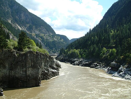
- Fraser Canyon (British Columbia)
- Fraser Valley (British Columbia)
- Grand Canyon (Arizona, United States)
- Hell's Gate (British Columbia)
- Hudson Valley (New York)
- Imperial Valley (California)
- Las Vegas Valley (Nevada)
- Missouri River Valley (Missouri)
- Monument Valley (Arizona, Utah)
- Napa Valley (California)
- Okanagan Valley (British Columbia)
- Ottawa Valley (Ontario/Quebec)
- Palo Duro Canyon (Texas)
- Valley of the Sun (Arizona)
- Rio Grande Valley (Texas)
- Rocky Mountain Trench (British Columbia/Montana)
- Saint Lawrence Valley (Ontario/Quebec/New York)
- Salt Lake Valley (Utah)
- San Fernando Valley (California)
- Shenandoah Valley (Virginia/West Virginia)
- Sonoma Valley (California)
- Toluca Valley (Mexico)
- Valley of the Gods (Utah)
- Valley of Mexico (Mexico)
- Willamette Valley (Oregon)
- Yosemite Valley (California)
South America
- Aburra Valley (Colombia)
- Calchaquí Valleys (Argentina)
- وادي كاوكا (كولومبيا)
- وادي القمر إيشيغوالاستو (الأرجنتين)
- وادي بارايبا (البرازيل)
أنتاركتيكا
وديان خارج الأرض
تم رصد العديد من المنخفضات الطويلة على سطح المريخ والزهرة والقمر وكواكب أخرى وأقمارها ، وتُعرف باسم " فاليس " (مفردها: "فاليس"). أما الوديان الأعمق ذات الجوانب الأكثر انحدارًا (شبيهة بالأودية) على بعض هذه الأجرام فتُعرف باسم "تشازماتا" (مفردها: "تشازما"). وتُسمى المنخفضات الطويلة الضيقة "فوساي" (مفردها: "فوسا"). [ 27 ] هذه هي المصطلحات اللاتينية التي تعني "وادي" و"مضيق" و"خندق" على التوالي. ويُستخدم المصطلح الألماني " ريل " أو المصطلح اللاتيني "ريما" (بمعنى "شق") لوصف بعض المنخفضات الطويلة الأخرى على سطح القمر. [ 28 ]
انظر أيضاً:
انظر أيضاً
- وادي العشب – مرج يقع داخل حوض تصريف صغير نسبياً ومغطى بالغابات
- الوادي - شكل أرضي يتكون بفعل المياه الجارية و/أو حركة الكتل التي تؤدي إلى تآكل التربة بشكل حاد
- وادي قديم – مجرى نهر أو مجرى مائي غير نشط تم ردمه أو دفنه. صفحات تعرض أوصافًا مختصرة لأهداف إعادة التوجيه
- مجرى مائي – مسطح مائي ضيق
مراجع
- 1 2 3 4 5 6 7 8 9 10 11 12 13 14 15 جودي، أندرو، محرر. (2013). "الوادي" . موسوعة الجيومورفولوجيا . روتليدج. ص 1089. ISBN 978-1-134-48276-4.
- ↑ شوم، ستانلي أ.؛ إيثريج، فرانك ج. "أصل وتطور وشكل الوديان النهرية". في دالريمبل، روبرت و.؛ بويد، رون؛ زيتلين، برايان أ. (محررون). أنظمة الوديان المتشعبة: الأصل والتتابعات الرسوبية . المجلد 51. جمعية SEPM لجيولوجيا الرسوبيات. doi : 10.2110/pec.94.12.0011 .
- ↑ "الوديان على شكل حرف U، والمضائق البحرية، والوديان المعلقة" . خدمة المتنزهات الوطنية الأمريكية . تم الاطلاع عليه بتاريخ 21-11-2025 .
- ↑ "أنظمة الأنهار والتضاريس النهرية" . خدمة المتنزهات الوطنية الأمريكية . تم الاطلاع عليه بتاريخ 21-11-2025 .
- ↑ مونكهاوس، إف جيه (1971). مبادئ الجغرافيا الطبيعية ( الطبعة السابعة). لندن: مطبعة جامعة لندن المحدودة. ص 152-157 . ISBN 0340090227.
- ↑ موريسوا، ماري (1968). رودس دبليو. فيربيردج (محرر). تصنيف الأنهار . نيويورك: مؤسسة رينهولد للنشر. الصفحات 956-957 . OCLC 2968 .
- ↑ مونكهاوس، إف جيه (1971). مبادئ الجغرافيا الطبيعية ( الطبعة السابعة). لندن: مطبعة جامعة لندن المحدودة. ص 161-164 . ISBN 0340090227.
- ↑ "وادي عدن" . بريتانيكا . تم الاطلاع عليه بتاريخ 20 ديسمبر 2020 .
- ↑ هيرانو، ماساسجيجي؛ أنيا، ماسامو (ديسمبر 1988). "تفسير منطقي لشكل المقطع العرضي للأودية الجليدية وتطورها". عمليات سطح الأرض وتضاريسها . مكتبة وايلي الإلكترونية. 13 (8): 707-716 . doi : 10.1002/esp.3290130805 .
- ↑ غراف، ويليام ل. (خريف 1970). "جيومورفولوجيا المقطع العرضي لوادي جليدي". بحوث القطب الشمالي وجبال الألب . 2 (4). تايلور وفرانسيس المحدودة: 303-312 . doi : 10.2307/1550243 . JSTOR 1550243 .
- ↑ مونكهاوس، إف جيه (1971). مبادئ الجغرافيا الطبيعية ( الطبعة السابعة). لندن: مطبعة جامعة لندن المحدودة. ص 230-234 . ISBN 0340090227.
- ↑ يورغنسن، فليمنغ؛ ساندرسن، بيتر بي إي (يونيو 2006). "أودية الأنفاق المدفونة والمفتوحة في الدنمارك - التعرية تحت طبقات جليدية متعددة". مراجعات علوم العصر الرباعي . 25 ( 11-12 ): 1339-1363 . رمز Bibcode : 2006QSRv...25.1339J . doi : 10.1016/j.quascirev.2005.11.006 .
- ↑ "مسرد مصطلحات الأنهار الجليدية" . هيئة المسح الجيولوجي الأمريكية. 28 مايو 2004. تم الاطلاع عليه بتاريخ 24 مايو 2007 .
- ^ نيسجي، أ. ويلانز، آي إم (فبراير 1994). “تآكل سوجنيفيورد، النرويج”. الجيومورفولوجيا . 9 (1): 33– 45. بيب كود : 1994Geomo...9...33N . دوى : 10.1016/0169-555X(94)90029-9 .
- ↑ "معجم مصور للأشكال الأرضية الجليدية في جبال الألب - وادي هانغينغ" . جامعة ويسكونسن، ستيفنز بوينت. مؤرشف من الأصل بتاريخ 9 يونيو 2011. تم الاطلاع عليه بتاريخ 3 أكتوبر 2011 .
- ↑ رولي، تايلور؛ جياردينو، جون ر.؛ غرانادوس-أغيلار، راكيل؛ فيتيك، جون د. (يناير 2015). "الفصل 13 - العمليات المحيطة بالجليد والتضاريس في المنطقة الحرجة". في جياردينو، جون ر.؛ هاوزر، كريس (محرران). مبادئ وديناميات المنطقة الحرجة . تطورات في عمليات سطح الأرض. المجلد 19. إلسيفير. الصفحات 397-447 . doi : 10.1016/B978-0-444-63369-9.00013-6 . ISBN 978-0-444-63369-9تم الاطلاع عليه بتاريخ 19-10-2023 .
- ↑ جودي، أندرو، محرر. (2004). موسوعة الجيومورفولوجيا . دار النشر النفسية. ص 98. ISBN 978-0-415-32738-1.
- ↑ "التاريخ المبكر لمقاطعة سانتا كلارا" . خدمة المتنزهات الوطنية . مؤرشف من الأصل في 3 يوليو 2007. تم الاطلاع عليه في 16 يناير 2015.
وادي سانتا كلارا هو وادٍ بنيوي، نشأ بفعل تكوين الجبال، على عكس الوادي التعرية، أو الوادي الذي تعرض لتآكل سطح الأرض بفعل العوامل الطبيعية.
- ^ روس ، ديفيد (2001). أسماء الأماكن الاسكتلندية (الطبعة الأولى ). ادنبره: بيرلين. ص. 203. ردمك 1841581739.
- ^ روس ، ديفيد (2001). أسماء الأماكن الاسكتلندية (الطبعة الأولى ). ادنبره: بيرلين. ص. 99. ردمك 1841581739.
- ^ روس ، ديفيد (2001). أسماء الأماكن الاسكتلندية (الطبعة الأولى ). ادنبره: بيرلين. ص. 53. ردمك 1841581739.
- ↑ ويتن، دي جي إيه؛ بروكس، جيه آر في (1972). قاموس الجيولوجيا ( الطبعة الأولى). لندن: بنغوين. ص 83. ISBN 0140510494.
- ↑ "خرائط بينغ" . مايكروسوفت بينغ . تم الاطلاع عليه بتاريخ 20 ديسمبر 2020 .
- ↑ جيلينج، مارغريت (1984). أسماء الأماكن في المشهد الطبيعي: الجذور الجغرافية لأسماء الأماكن في بريطانيا ( الطبعة الأولى). لندن: جي إم دينت. ص 88. ISBN 0460860860.
- ↑ جيلينج، مارغريت (1984). أسماء الأماكن في المشهد الطبيعي: الجذور الجغرافية لأسماء الأماكن في بريطانيا ( الطبعة الأولى). لندن: جيه إم دينت. ص 99. ISBN 0460860860.
- ↑ "Combe" . قاموس ميريام-ويبستر . ميريام-ويبستر. 2011.
- ↑ "دليل تسمية الكواكب، أنواع السمات" . الاتحاد الفلكي الدولي . تم الاطلاع عليه بتاريخ 20 ديسمبر 2020 .
- ↑ "دليل تسمية الكواكب، مرحباً" . الاتحاد الفلكي الدولي . تم الاطلاع عليه بتاريخ 20 ديسمبر 2020 .
روابط خارجية
- موقع NPS.gov ، جامعة ويسكونسن
- UWSP.edu ، مسرد التضاريس الجليدية الألبية
- "BGU.ac.il" (PDF) .، قياس التداخل الراداري ذي الفتحة التركيبية (تحليل أشكال الوديان في الشكلين 2 و6)
- موقع Valleys.com ، وديان العالم
- تعريفات الوادي ، قاموسك
وديان خارج الأرض
- صورة وكالة الفضاء الأوروبية : فاليس ألب ، تقسم جبال الألب القمرية
- موقع إلكتروني ثنائي اللغة ( الإنجليزية والألمانية ) بعنوان " وادي مارينيريس وأوفير تشاسما "
- الوديان
- أشكال التعرية الأرضية
- التضاريس النهرية
- تضاريس المنحدرات
- المسطحات المائية